Map of West View borough
West View is a borough in Allegheny County in the U.S. state of Pennsylvania, just north of downtown Pittsburgh. The population was 6,685 at the 2020 census. West View borough overview: Name: West View borough LSAD Code: 21 LSAD Description: borough (suffix) State: Pennsylvania County: Allegheny County Total Area: 1.01 sq mi (2.62 km²) Land Area: 1.01 sq mi (2.62 km²) ... Read more
Map of West View borough
Map of West Sunbury borough
West Sunbury is a borough in Butler County, Pennsylvania, United States. The population was 192 at the 2010 census. West Sunbury borough overview: Name: West Sunbury borough LSAD Code: 21 LSAD Description: borough (suffix) State: Pennsylvania County: Butler County Incorporated: 1866 Total Area: 0.11 sq mi (0.29 km²) Land Area: 0.11 sq mi (0.29 km²) Water Area: 0.00 sq mi (0.00 km²) Total Population: ... Read more
Map of West Sunbury borough
Map of West Reading borough
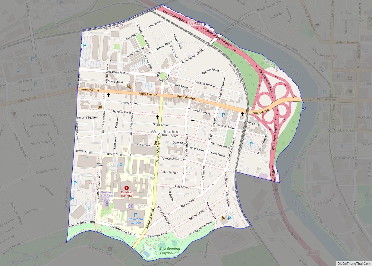
West Reading is a borough in Berks County, Pennsylvania, United States. The population was 4,212 at the 2010 census. It contains a vibrant main street (Penn Avenue) and the large Reading Hospital and Medical Center. It was also the site of the VF Outlet Village, one of the largest outlet malls in the United States. ... Read more
Map of West Reading borough
Map of West Pittston borough
West Pittston is a borough in the Greater Pittston area of Luzerne County, Pennsylvania, United States. It is located on the Susquehanna River (opposite of Pittston City). In 2020, the population was 4,644. The town once produced mine screens, glass, crackers, and many other goods. West Pittston rose to national attention in September 2011, when ... Read more
Map of West Pittston borough
Map of West Pittsburg CDP
West Pittsburg is an unincorporated community and census-designated place (CDP) in southern Taylor Township, Lawrence County, Pennsylvania, United States. As of the 2010 census it had a population of 808. It is located in the Beaver River valley 5 miles (8 km) south of New Castle. Its main street is the north-south Pennsylvania Route 168, which ... Read more
Map of West Pittsburg CDP
Map of West Newton borough
West Newton, located 24.5 miles (39.4 km) southeast of Pittsburgh, is a borough in Westmoreland County in the U.S. state of Pennsylvania. Formerly, the manufacture of radiators and boilers were the chief industries. The population was 2,633 at the 2010 census. West Newton borough overview: Name: West Newton borough LSAD Code: 21 LSAD Description: borough (suffix) ... Read more
Map of West Newton borough
Map of West Nanticoke CDP
West Nanticoke is a census-designated place (CDP) in Plymouth Township, Luzerne County, Pennsylvania, United States, across the Susquehanna River from the city of Nanticoke. The population of the CDP was 749 at the 2010 census. West Nanticoke CDP overview: Name: West Nanticoke CDP LSAD Code: 57 LSAD Description: CDP (suffix) State: Pennsylvania County: Luzerne County ... Read more
Map of West Nanticoke CDP
Map of West Milton CDP, Pennsylvania
West Milton is a census-designated place located in Kelly and White Deer Townships in Union County in the state of Pennsylvania. The community is located directly across the West Branch Susquehanna River from the borough of Milton which is located in Northumberland County, from which West Milton derived its name. West Milton is located along ... Read more
Map of West Milton CDP, Pennsylvania
Map of Weston CDP, Pennsylvania
Weston is a census-designated place (CDP) in Black Creek Township, Luzerne County, Pennsylvania, United States. The population was 321 at the 2010 census. Weston CDP overview: Name: Weston CDP LSAD Code: 57 LSAD Description: CDP (suffix) State: Pennsylvania County: Luzerne County Total Area: 0.4 sq mi (1.1 km²) Land Area: 0.4 sq mi (1.1 km²) Water Area: 0 sq mi (0 km²) Total Population: ... Read more
Map of Weston CDP, Pennsylvania
Map of Westmont borough, Pennsylvania
Westmont is a borough in Cambria County, Pennsylvania, United States. It is part of the Johnstown, Pennsylvania Metropolitan Statistical Area. The population was 5,181 at the 2010 census, down from 5,523 at the 2000 census. Westmont borough overview: Name: Westmont borough LSAD Code: 21 LSAD Description: borough (suffix) State: Pennsylvania County: Cambria County Incorporated: 1892 ... Read more
Map of Westmont borough, Pennsylvania
Map of Westland CDP, Pennsylvania
Westland is a census-designated place located in Mount Pleasant and Chartiers Townships in Washington County in the state of Pennsylvania. The community is located in northern Washington County along Pennsylvania Route 519 about 5 miles northwest of the community of McGovern. As of the 2010 census the population was 167 residents. Westland CDP overview: Name: ... Read more
Map of Westland CDP, Pennsylvania
Map of Westfield borough, Pennsylvania
Westfield is a borough in Tioga County, Pennsylvania, United States. The population was 1,113 at the time of the 2020 census. Westfield borough overview: Name: Westfield borough LSAD Code: 21 LSAD Description: borough (suffix) State: Pennsylvania County: Tioga County Elevation: 1,365 ft (416 m) Total Area: 1.11 sq mi (2.89 km²) Land Area: 1.11 sq mi (2.89 km²) Water Area: 0.00 sq mi (0.00 km²) Total ... Read more
Map of Westfield borough, Pennsylvania