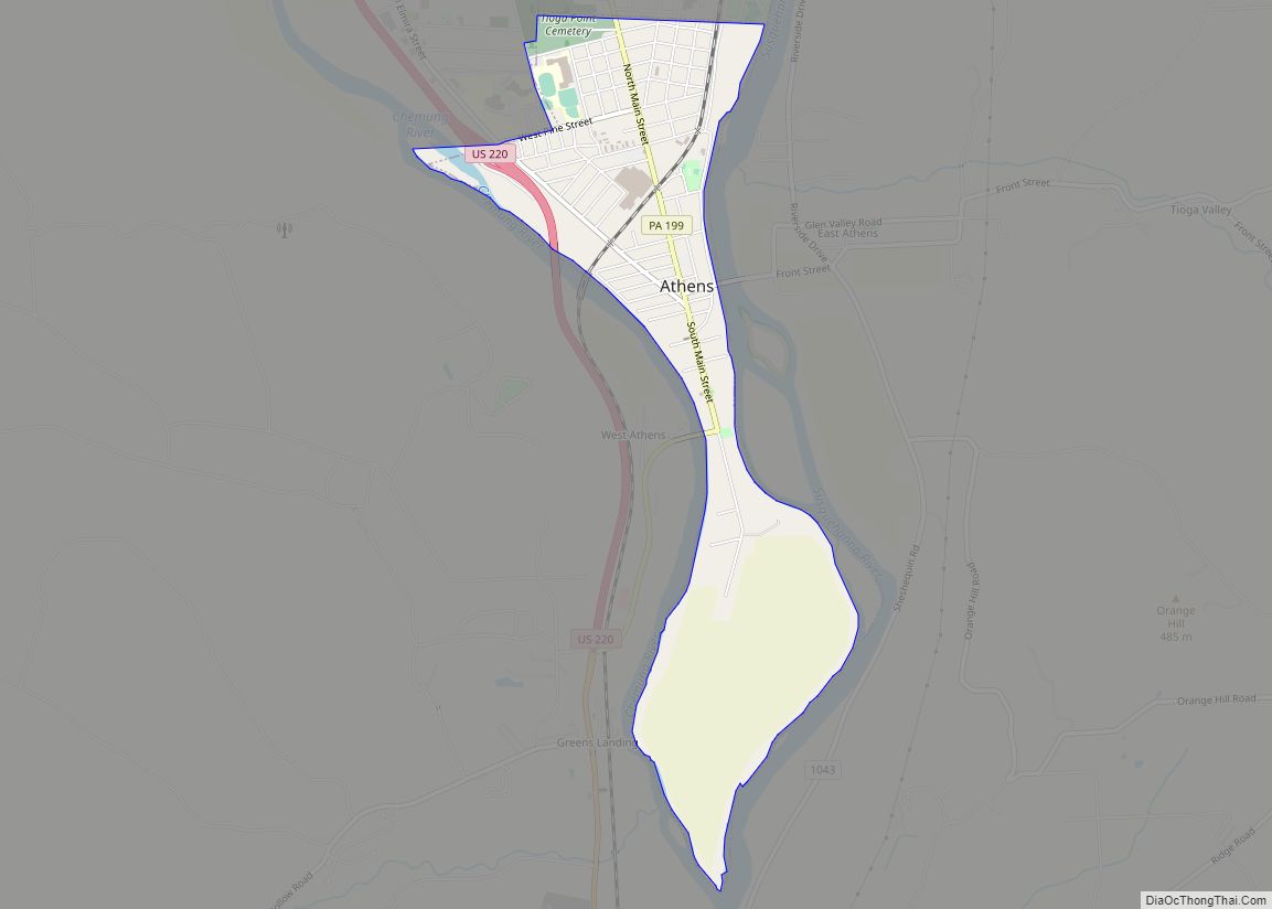
Map of Aspinwall borough, Pennsylvania
Aspinwall is a borough on the Allegheny River in Allegheny County, Pennsylvania, United States. It is part of the Greater Pittsburgh metropolitan area. In 1900, 1,231 people lived in Aspinwall, and that number rose to 2,592 in 1910, and 3,170 by 1920. The population was 2,916 at the 2020 census. Aspinwall borough overview: Name: Aspinwall ... Read more
Map of Aspinwall borough, Pennsylvania
Map of Aspers CDP
Aspers is a census-designated place in Adams County, Pennsylvania, United States. As of the 2020 census, it had a population of 486. At the 2000 census it was listed as the Bendersville Station-Aspers CDP. Aspers CDP overview: Name: Aspers CDP LSAD Code: 57 LSAD Description: CDP (suffix) State: Pennsylvania County: Adams County Total Area: 0.92 sq mi ... Read more
Map of Aspers CDP
Map of Avoca borough, Pennsylvania
Avoca is a borough within the Greater Pittston area of Luzerne County, Pennsylvania, United States. It is located 7.5 miles (12.1 km) northeast of Wilkes Barre and 3.4 miles (5.5 km) southwest of Scranton. The population was 2,501 at the time of the 2020 census. The Wilkes-Barre/Scranton International Airport (AVP) is located near Avoca (in Pittston Township). ... Read more
Map of Avoca borough, Pennsylvania
Map of Avis borough
Avis is a borough in Clinton County, Pennsylvania, United States. The population was 1,484 at the 2010 census. Avis borough overview: Name: Avis borough LSAD Code: 21 LSAD Description: borough (suffix) State: Pennsylvania County: Clinton County Elevation: 595 ft (181 m) Total Area: 0.49 sq mi (1.28 km²) Land Area: 0.49 sq mi (1.28 km²) Water Area: 0.00 sq mi (0.00 km²) Total Population: 1,473 Population ... Read more
Map of Avis borough
Map of Avella CDP
Avella is a census-designated place in Independence Township, Washington County, Pennsylvania, United States. As of the 2010 census the population was 804 residents. It is located at 40.27° north & 80.45° west. Avella CDP overview: Name: Avella CDP LSAD Code: 57 LSAD Description: CDP (suffix) State: Pennsylvania County: Washington County Total Area: 0.90 sq mi (2.33 km²) Land ... Read more
Map of Avella CDP
Map of Avalon borough, Pennsylvania
Avalon is a borough in Allegheny County, Pennsylvania, United States, along the Ohio River, 6 miles (10 km) downstream from Pittsburgh. The population was 4,762 at the 2020 census. It is a residential suburb of the Pittsburgh metropolitan area. Avalon borough overview: Name: Avalon borough LSAD Code: 21 LSAD Description: borough (suffix) State: Pennsylvania County: Allegheny ... Read more
Map of Avalon borough, Pennsylvania
Map of Austin borough, Pennsylvania
Austin is a borough along the Freeman Run (river) in southwestern Potter County, Pennsylvania, United States. The population was 482 at the 2020 census. Austin borough overview: Name: Austin borough LSAD Code: 21 LSAD Description: borough (suffix) State: Pennsylvania County: Potter County Total Area: 4.04 sq mi (10.47 km²) Land Area: 4.04 sq mi (10.47 km²) Water Area: 0.00 sq mi (0.00 km²) Total ... Read more
Map of Austin borough, Pennsylvania
Map of Audubon CDP, Pennsylvania
Audubon is a census-designated place (CDP) in Lower Providence Township, Montgomery County, Pennsylvania, United States. It was named for naturalist John James Audubon, who lived there as a young man. The population was 8,433 at the 2010 census. Audubon CDP overview: Name: Audubon CDP LSAD Code: 57 LSAD Description: CDP (suffix) State: Pennsylvania County: Montgomery ... Read more
Map of Audubon CDP, Pennsylvania
Map of Auburn borough, Pennsylvania
Auburn is a borough in Schuylkill County, Pennsylvania, United States. The population was 663 at the 2020 census. Auburn borough overview: Name: Auburn borough LSAD Code: 21 LSAD Description: borough (suffix) State: Pennsylvania County: Schuylkill County Incorporated: 1857 Elevation: 479 ft (146 m) Total Area: 1.67 sq mi (4.34 km²) Land Area: 1.62 sq mi (4.20 km²) Water Area: 0.05 sq mi (0.13 km²) Total Population: ... Read more
Map of Auburn borough, Pennsylvania
Map of Atwood borough, Pennsylvania
Atwood is a borough in Armstrong County, Pennsylvania, United States. The population was 112 at the 2020 census. Atwood borough overview: Name: Atwood borough LSAD Code: 21 LSAD Description: borough (suffix) State: Pennsylvania County: Armstrong County Incorporated: 1884 Total Area: 2.11 sq mi (5.47 km²) Land Area: 2.09 sq mi (5.42 km²) Water Area: 0.02 sq mi (0.05 km²) Total Population: 112 Population Density: ... Read more
Map of Atwood borough, Pennsylvania
Map of Avondale borough, Pennsylvania
Avondale is a borough in Chester County, in southeastern Pennsylvania, United States. The population was 1,272 at the 2020 census. Avondale borough overview: Name: Avondale borough LSAD Code: 21 LSAD Description: borough (suffix) State: Pennsylvania County: Chester County Elevation: 266 ft (81 m) Total Area: 0.50 sq mi (1.28 km²) Land Area: 0.48 sq mi (1.25 km²) Water Area: 0.01 sq mi (0.03 km²) Total Population: ... Read more
Map of Avondale borough, Pennsylvania
Map of Avon CDP, Pennsylvania
Avon is an unincorporated community and census-designated place (CDP) in Lebanon County, Pennsylvania, United States. The population was 1,667 at the 2010 census, a decline from the figure of 2,856 tabulated in 2000. Avon CDP overview: Name: Avon CDP LSAD Code: 57 LSAD Description: CDP (suffix) State: Pennsylvania County: Lebanon County Elevation: 478 ft (146 m) Total ... Read more
Map of Avon CDP, Pennsylvania