Map of Moosic borough
Moosic (/ˈmuːzɪk/ MOO-zik) is a borough in Lackawanna County, Pennsylvania, United States, 3 miles (5 km) south of downtown Scranton and 10 miles (16 km) northeast of downtown Wilkes-Barre, on the Lackawanna River. Moosic is in a former coal-mining region. A few older industries existed at one time, including the manufacturing of canvas gloves and silk products. ... Read more
Map of Moosic borough
Map of Monument CDP, Pennsylvania
Monument is an unincorporated community and census-designated place in Centre County, Pennsylvania, United States. It is part of the State College, Pennsylvania Metropolitan Statistical Area. The population was 150 at the 2010 census. The economy of Monument was heavily dependent on the brick-works that Harbison-Walker Refractories built in approximately 1901. This produced refractory bricks, used ... Read more
Map of Monument CDP, Pennsylvania
Map of Montrose borough, Pennsylvania
Montrose is a borough in Susquehanna County, Pennsylvania, United States, 18.41 miles (29.63 km) south-southeast of Binghamton, New York and 31.39 miles (50.52 km) north by west of Scranton. The land is elevated approximately 1,400 feet (430 m) above sea level. It is the Susquehanna County seat. Montrose borough overview: Name: Montrose borough LSAD Code: 21 LSAD Description: ... Read more
Map of Montrose borough, Pennsylvania
Map of Mount Aetna CDP, Pennsylvania
Mount Aetna is a census-designated place in Tulpehocken Township, Berks County, Pennsylvania, United States. It is located along Pennsylvania Route 501 near the border of Lebanon County. The community is named after the active volcano, Mount Etna, in Sicily. As of the 2010 census, the population was 354 residents. Mount Aetna CDP overview: Name: Mount ... Read more
Map of Mount Aetna CDP, Pennsylvania
Map of Moshannon CDP
Moshannon is an unincorporated community and census-designated place (CDP) in Snow Shoe Township, Centre County, Pennsylvania, United States. As of the 2010 census, the population was 281 residents. It is located 4 miles (6 km) northwest of Interstate 80 at the convergence of Pennsylvania Routes 53 and 144. Black Moshannon Creek, part of the West Branch ... Read more
Map of Moshannon CDP
Map of Moscow borough, Pennsylvania
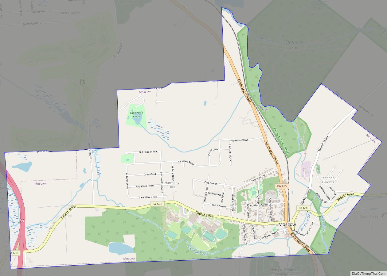
Moscow is a borough in Lackawanna County, Pennsylvania, United States. The population was 2,039 at the 2020 census. It is located 11 miles (18 km) southeast of Scranton and 24 miles (39 km) southwest of Honesdale. Moscow borough overview: Name: Moscow borough LSAD Code: 21 LSAD Description: borough (suffix) State: Pennsylvania County: Lackawanna County Elevation: 1,722 ft (525 m) ... Read more
Map of Moscow borough, Pennsylvania
Map of Morton borough, Pennsylvania
Morton is a borough in Delaware County, Pennsylvania, United States. The population was 2,778 at the 2020 census. Morton borough overview: Name: Morton borough LSAD Code: 21 LSAD Description: borough (suffix) State: Pennsylvania County: Delaware County Elevation: 141 ft (43 m) Total Area: 0.36 sq mi (0.93 km²) Land Area: 0.36 sq mi (0.93 km²) Water Area: 0.00 sq mi (0.00 km²) Total Population: 2,278 Population ... Read more
Map of Morton borough, Pennsylvania
Map of Morrisville CDP, Pennsylvania
Morrisville is a census-designated place (CDP) in Franklin Township, Greene County, Pennsylvania, United States. The population was 1,265 at the 2010 census. Morrisville CDP overview: Name: Morrisville CDP LSAD Code: 57 LSAD Description: CDP (suffix) State: Pennsylvania County: Greene County Total Area: 1.54 sq mi (3.99 km²) Land Area: 1.54 sq mi (3.99 km²) Water Area: 0.00 sq mi (0.00 km²) Total Population: 1,209 ... Read more
Map of Morrisville CDP, Pennsylvania
Map of Mount Morris CDP, Pennsylvania
Mount Morris is an unincorporated community and census-designated place (CDP) in Greene County, Pennsylvania, United States. It is located in Perry Township, near I-79. As of the 2010 census, the population was 737. Mount Morris CDP overview: Name: Mount Morris CDP LSAD Code: 57 LSAD Description: CDP (suffix) State: Pennsylvania County: Greene County Elevation: 938 ft ... Read more
Map of Mount Morris CDP, Pennsylvania
Map of Mount Joy borough
Mount Joy is a borough in Lancaster County, Pennsylvania, United States. The population was 8,346 at the 2020 census, and an estimated 8,323 in 2021. Mount Joy borough overview: Name: Mount Joy borough LSAD Code: 21 LSAD Description: borough (suffix) State: Pennsylvania County: Lancaster County Elevation: 371 ft (113 m) Total Area: 2.43 sq mi (6.28 km²) Land Area: 2.41 sq mi ... Read more
Map of Mount Joy borough
Map of Mount Jewett borough
Mount Jewett is a borough in McKean County, Pennsylvania, United States. The population was 849 at the 2020 census. The students of the borough attend school in the Kane Area School District, even though the borough is surrounded by Hamlin Township—belonging to neighboring Smethport Area School District. Mount Jewett is near to the Kinzua Bridge ... Read more
Map of Mount Jewett borough
Map of Mount Holly Springs borough
Mount Holly Springs is a borough in Cumberland County, Pennsylvania, United States. The borough is located 25 miles north of Gettysburg. The population was 2,030 at the 2010 census. It is part of the Harrisburg–Carlisle metropolitan statistical area. Mount Holly Springs borough overview: Name: Mount Holly Springs borough LSAD Code: 21 LSAD Description: borough (suffix) ... Read more
Map of Mount Holly Springs borough