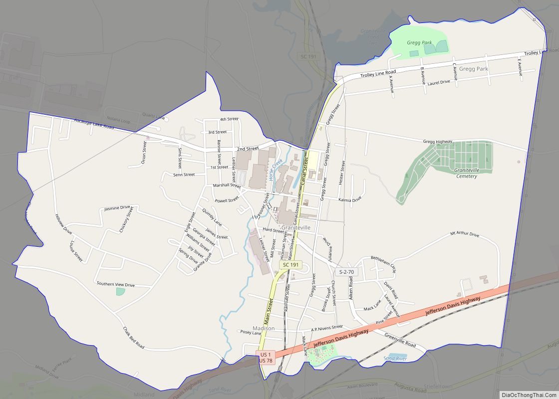
Map of Gray Court town
Gray Court is a town in Laurens County, South Carolina, United States. The population was 795 at the 2010 census. It is part of the Greenville–Mauldin–Easley Metropolitan Statistical Area. Gray Court town overview: Name: Gray Court town LSAD Code: 43 LSAD Description: town (suffix) State: South Carolina County: Laurens County Elevation: 801 ft (244 m) Total Area: ... Read more
Map of Gray Court town
Map of Hilton Head Island town
Hilton Head Island, sometimes referred to as simply Hilton Head, is a Lowcountry resort town and barrier island in Beaufort County, South Carolina, United States. It is 20 miles (32 km) northeast of Savannah, Georgia, and 95 miles (153 km) southwest of Charleston. The island is named after Captain William Hilton, who in 1663 identified a headland ... Read more
Map of Hilton Head Island town
Map of Hilda town
Hilda is a town in Barnwell County, South Carolina, United States. The population was 447 at the 2010 census. Hilda town overview: Name: Hilda town LSAD Code: 43 LSAD Description: town (suffix) State: South Carolina County: Barnwell County Elevation: 259 ft (79 m) Total Area: 3.11 sq mi (8.05 km²) Land Area: 3.07 sq mi (7.95 km²) Water Area: 0.04 sq mi (0.10 km²) Total Population: ... Read more
Map of Hilda town
Map of Hickory Grove town
Hickory Grove is a town in York County, South Carolina, United States. The population was 440 at the 2010 census. Hickory Grove town overview: Name: Hickory Grove town LSAD Code: 43 LSAD Description: town (suffix) State: South Carolina County: York County Elevation: 682 ft (208 m) Total Area: 1.67 sq mi (4.33 km²) Land Area: 1.67 sq mi (4.33 km²) Water Area: 0.00 sq mi ... Read more
Map of Hickory Grove town
Map of Hemingway town
Hemingway is a town in Williamsburg County, South Carolina, United States. The population was 459 at the 2010 census. Hemingway town overview: Name: Hemingway town LSAD Code: 43 LSAD Description: town (suffix) State: South Carolina County: Williamsburg County Elevation: 52 ft (16 m) Total Area: 0.86 sq mi (2.24 km²) Land Area: 0.86 sq mi (2.24 km²) Water Area: 0.00 sq mi (0.00 km²) Total Population: ... Read more
Map of Hemingway town
Map of Heath Springs town
Heath Springs is a town in Lancaster County, South Carolina, United States. The population was 742 at the 2020 census. Heath Springs town overview: Name: Heath Springs town LSAD Code: 43 LSAD Description: town (suffix) State: South Carolina County: Lancaster County Elevation: 686 ft (209 m) Total Area: 1.63 sq mi (4.21 km²) Land Area: 1.63 sq mi (4.21 km²) Water Area: 0.00 sq mi ... Read more
Map of Heath Springs town
Map of Hartsville city, South Carolina
Hartsville is the largest city in Darlington County, South Carolina, United States. It was chartered on December 11, 1891. The population was 7,764 at the 2010 census. Hartsville was chosen as an All-America City in 1996 and again in 2016. Hartsville has also been a National Arbor Day Foundation Tree City since 1986. Hartsville is ... Read more
Map of Hartsville city, South Carolina
Map of Harleyville town
Harleyville is a town in Dorchester County, South Carolina, United States. The population was 677 at the 2010 census, up from 594 at the 2000 census. Harleyville is part of the Charleston-North Charleston-Summerville metropolitan area. As of 2018 the population is 696. Harleyville town overview: Name: Harleyville town LSAD Code: 43 LSAD Description: town (suffix) ... Read more
Map of Harleyville town
Map of Hollywood town, South Carolina
Hollywood is a town in Charleston County, South Carolina, United States. The population was 4,714 at the 2010 census, up from 3,946 in 2000. Hollywood is part of the Charleston, South Carolina metropolitan area and the Charleston-North Charleston Urbanized Area. Hollywood town overview: Name: Hollywood town LSAD Code: 43 LSAD Description: town (suffix) State: South ... Read more
Map of Hollywood town, South Carolina
Map of Holly Hill town, South Carolina
Holly Hill is a town in Orangeburg County, South Carolina, United States. The population was 1,277 at the 2010 census. Prior to 1910 it was located in the northwest portion of Saint James Goose Creek Township, Berkeley County. Holly Hill town overview: Name: Holly Hill town LSAD Code: 43 LSAD Description: town (suffix) State: South ... Read more
Map of Holly Hill town, South Carolina
Map of Hodges town, South Carolina
Hodges is a town in Greenwood County, South Carolina, United States. The population was 155 at the 2010 census. The mayor is Michael George. Hodges was named after Major General George Washington Hodges, who was commander of all of South Carolina’s militia. Hodges was born September 9, 1792, and died March 24, 1876. He fought ... Read more
Map of Hodges town, South Carolina
Map of Isle of Palms city
Isle of Palms is a city in Charleston County, South Carolina, United States. At the 2010 census, the population was 4,133. Isle of Palms is a barrier island on the South Carolina coast. The city is included within the Charleston-North Charleston-Summerville metropolitan area and the Charleston-North Charleston Urbanized Area. The town lies along a narrow ... Read more
Map of Isle of Palms city