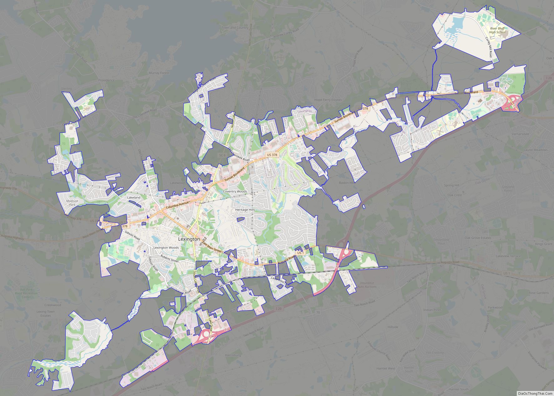
Map of Little River CDP, South Carolina
Little River is a census-designated place (CDP) in Horry County, South Carolina, United States. The population was 11,711 at the 2020 census. Little River is named for the Little River, which flows into the Atlantic Ocean at the state line between North Carolina and South Carolina. The Little River inlet has long been a breakpoint ... Read more
Map of Little River CDP, South Carolina
Map of Marion city, South Carolina
Marion is a city in and the county seat of Marion County, South Carolina, United States. It is named for Francis Marion, a brigadier general from South Carolina in the American Revolutionary War. The population was 6,939 at the 2010 census. Marion city overview: Name: Marion city LSAD Code: 25 LSAD Description: city (suffix) State: ... Read more
Map of Marion city, South Carolina
Map of Manning city, South Carolina
Manning is a city in and the county seat of Clarendon County, South Carolina, United States. The population was 4,108 as of the 2010 census, with an estimated population in 2018 of 3,941. It was named after former South Carolina governor John Laurence Manning. Manning city overview: Name: Manning city LSAD Code: 25 LSAD Description: ... Read more
Map of Manning city, South Carolina
Map of Lynchburg town, South Carolina
Lynchburg is a town in Sumter and Lee County, South Carolina, United States. The population was 373 at the 2010 census. Lynchburg town overview: Name: Lynchburg town LSAD Code: 43 LSAD Description: town (suffix) State: South Carolina County: Lee County Elevation: 151 ft (46 m) Total Area: 1.13 sq mi (2.93 km²) Land Area: 1.13 sq mi (2.93 km²) Water Area: 0.00 sq mi (0.00 km²) ... Read more
Map of Lynchburg town, South Carolina
Map of Lyman town, South Carolina
Lyman is a town in Spartanburg County, South Carolina, United States. Its population was 6,173 at the 2020 census. Lyman town overview: Name: Lyman town LSAD Code: 43 LSAD Description: town (suffix) State: South Carolina County: Spartanburg County Incorporated: 1954 Elevation: 886 ft (270 m) Total Area: 7.30 sq mi (18.91 km²) Land Area: 6.63 sq mi (17.16 km²) Water Area: 0.68 sq mi (1.75 km²) ... Read more
Map of Lyman town, South Carolina
Map of Lydia CDP, South Carolina
Lydia (formerly Mount Elon) is an unincorporated community and census-designated place (CDP) in Darlington County, South Carolina, United States. As of the 2010 census, the population of the CDP was 642. It is the location of Lydia Plantation, which is listed on the U.S. National Register of Historic Places. Lydia is in western Darlington County, ... Read more
Map of Lydia CDP, South Carolina
Map of Luray town, South Carolina
Luray is a town in Hampton County, South Carolina, United States. The population was 127 at the 2010 census. Luray town overview: Name: Luray town LSAD Code: 43 LSAD Description: town (suffix) State: South Carolina County: Hampton County Elevation: 138 ft (42 m) Total Area: 1.03 sq mi (2.68 km²) Land Area: 1.03 sq mi (2.68 km²) Water Area: 0.00 sq mi (0.00 km²) Total Population: ... Read more
Map of Luray town, South Carolina
Map of Lugoff CDP
Lugoff (/ˈljuːɡɒf/ LEW-gof) is an unincorporated community and census-designated place (CDP) in Kershaw County, South Carolina, United States. The population was 7,434 at the 2010 census, up from 6,278 at the 2000 census. It is part of the Columbia, South Carolina Metropolitan Statistical Area. Lugoff CDP overview: Name: Lugoff CDP LSAD Code: 57 LSAD Description: ... Read more
Map of Lugoff CDP
Map of Lowrys town
Lowrys is a small rural town in Chester County, South Carolina, United States. The population was 200 at the 2010 census. Lowrys town overview: Name: Lowrys town LSAD Code: 43 LSAD Description: town (suffix) State: South Carolina County: Chester County Elevation: 725 ft (221 m) Total Area: 3.16 sq mi (8.19 km²) Land Area: 3.16 sq mi (8.19 km²) Water Area: 0.00 sq mi (0.00 km²) ... Read more
Map of Lowrys town
Map of Lowndesville town
Lowndesville is a town in Abbeville County, South Carolina, United States. The population was 128 at the 2010 census. Lowndesville town overview: Name: Lowndesville town LSAD Code: 43 LSAD Description: town (suffix) State: South Carolina County: Abbeville County Elevation: 610 ft (190 m) Total Area: 0.78 sq mi (2.01 km²) Land Area: 0.78 sq mi (2.01 km²) Water Area: 0.00 sq mi (0.00 km²) Total Population: ... Read more
Map of Lowndesville town
Map of Loris city
Loris is a city in Horry County, South Carolina, United States. The population was 2,396 at the 2010 census, up from 2,079 in 2000. Loris city overview: Name: Loris city LSAD Code: 25 LSAD Description: city (suffix) State: South Carolina County: Horry County Elevation: 98 ft (30 m) Total Area: 4.57 sq mi (11.84 km²) Land Area: 4.55 sq mi (11.79 km²) Water ... Read more
Map of Loris city
Map of Mayesville town
Mayesville is a town in Sumter County, South Carolina, United States. The population was 731 at the 2010 census, this was a decline from 1,001 in 2000. It is included in the Sumter, South Carolina Metropolitan Statistical Area. Mayesville town overview: Name: Mayesville town LSAD Code: 43 LSAD Description: town (suffix) State: South Carolina County: ... Read more
Map of Mayesville town