Map of Meggett town
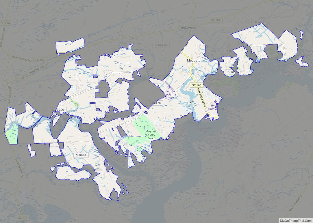
Meggett is a town in Charleston County, South Carolina, United States. The population was 1,226 at the 2010 census. Meggett is part of the Charleston-North Charleston-Summerville metropolitan area. Meggett town overview: Name: Meggett town LSAD Code: 43 LSAD Description: town (suffix) State: South Carolina County: Charleston County Elevation: 10 ft (3 m) Total Area: 18.76 sq mi (48.59 km²) Land ... Read more
Map of Meggett town
Map of McCormick town
McCormick is a town in McCormick County, South Carolina, United States. The population was 2,232 at the 2020 census. It is the county seat of McCormick County. The town of McCormick is named for inventor Cyrus McCormick. McCormick town overview: Name: McCormick town LSAD Code: 43 LSAD Description: town (suffix) State: South Carolina County: McCormick ... Read more
Map of McCormick town
Map of McConnells town
McConnells is a town in York County, South Carolina, United States and a suburb of York. The population was 255 at the 2010 census. McConnells town overview: Name: McConnells town LSAD Code: 43 LSAD Description: town (suffix) State: South Carolina County: York County Elevation: 689 ft (210 m) Total Area: 3.42 sq mi (8.86 km²) Land Area: 3.39 sq mi (8.78 km²) Water ... Read more
Map of McConnells town
Map of McColl town
McColl is a town in Marlboro County, South Carolina, United States. It lies in the state’s Pee Dee region, 8 miles (13 km) from the North Carolina border. The population was 2,174 at the 2010 census. McColl is the home of the Pee Dee Indian Tribe. They are a relatively small American Indian tribe that has ... Read more
Map of McColl town
Map of McClellanville town
McClellanville is a small fishing town in rural Charleston County, South Carolina, United States. The population was 1,040 at the 2010 census. It is situated on the Atlantic coast, on land surrounded by Francis Marion National Forest, and has traditionally derived its livelihood from the Atlantic Ocean and coastal marshes by fishing, shrimping and oystering. ... Read more
Map of McClellanville town
Map of McBee town
McBee /ˈmækbi/ is a town in Chesterfield County, South Carolina, United States. As of the 2010 census, the population was 867. McBee is approximately 36 miles (58 km) northwest of Florence and 62 miles (100 km) northeast of Columbia. McBee town overview: Name: McBee town LSAD Code: 43 LSAD Description: town (suffix) State: South Carolina County: Chesterfield ... Read more
Map of McBee town
Map of Mayo CDP, South Carolina
Mayo is a census-designated place (CDP) in Spartanburg County, South Carolina, United States. The population was 1,592 at the 2010 census. Mayo CDP overview: Name: Mayo CDP LSAD Code: 57 LSAD Description: CDP (suffix) State: South Carolina County: Spartanburg County Elevation: 889 ft (271 m) Total Area: 3.04 sq mi (7.88 km²) Land Area: 3.04 sq mi (7.88 km²) Water Area: 0.00 sq mi (0.00 km²) ... Read more
Map of Mayo CDP, South Carolina
Map of Mayesville town
Mayesville is a town in Sumter County, South Carolina, United States. The population was 731 at the 2010 census, this was a decline from 1,001 in 2000. It is included in the Sumter, South Carolina Metropolitan Statistical Area. Mayesville town overview: Name: Mayesville town LSAD Code: 43 LSAD Description: town (suffix) State: South Carolina County: ... Read more
Map of Mayesville town
Map of Mauldin city
Mauldin is a city in Greenville County, South Carolina, United States. The population was 24,724 at the 2020 census. It is a principal city of the Greenville–Anderson-Mauldin Metropolitan Statistical Area. Mauldin city overview: Name: Mauldin city LSAD Code: 25 LSAD Description: city (suffix) State: South Carolina County: Greenville County Founded: 1784 Elevation: 942 ft (287 m) Land ... Read more
Map of Mauldin city
Map of Mount Carmel CDP, South Carolina
Mt. Carmel is a census-designated place (CDP) in McCormick County, South Carolina, United States. The population was 237 at the 2000 census. Mount Carmel CDP overview: Name: Mount Carmel CDP LSAD Code: 57 LSAD Description: CDP (suffix) State: South Carolina County: McCormick County Elevation: 541 ft (165 m) Total Area: 9.19 sq mi (23.80 km²) Land Area: 9.19 sq mi (23.80 km²) Water ... Read more
Map of Mount Carmel CDP, South Carolina
Map of Monetta town
Monetta is a town in Aiken and Saluda counties, South Carolina, United States. The population was 236 at the 2010 census. The Aiken County portion of Monetta is part of the Augusta, Georgia metropolitan area. The Saluda County portion of Monetta is part of the Columbia, SC Metropolitan Area. Monetta town overview: Name: Monetta town ... Read more
Map of Monetta town
Map of Moncks Corner town
Moncks Corner is a town in and the county seat of Berkeley County, South Carolina, United States. The population was 7,885 at the 2010 census. As defined by the U.S. Census Bureau, Moncks Corner is included within the Charleston-North Charleston-Summerville Metropolitan Statistical Area. Moncks Corner town overview: Name: Moncks Corner town LSAD Code: 43 LSAD ... Read more
Map of Moncks Corner town