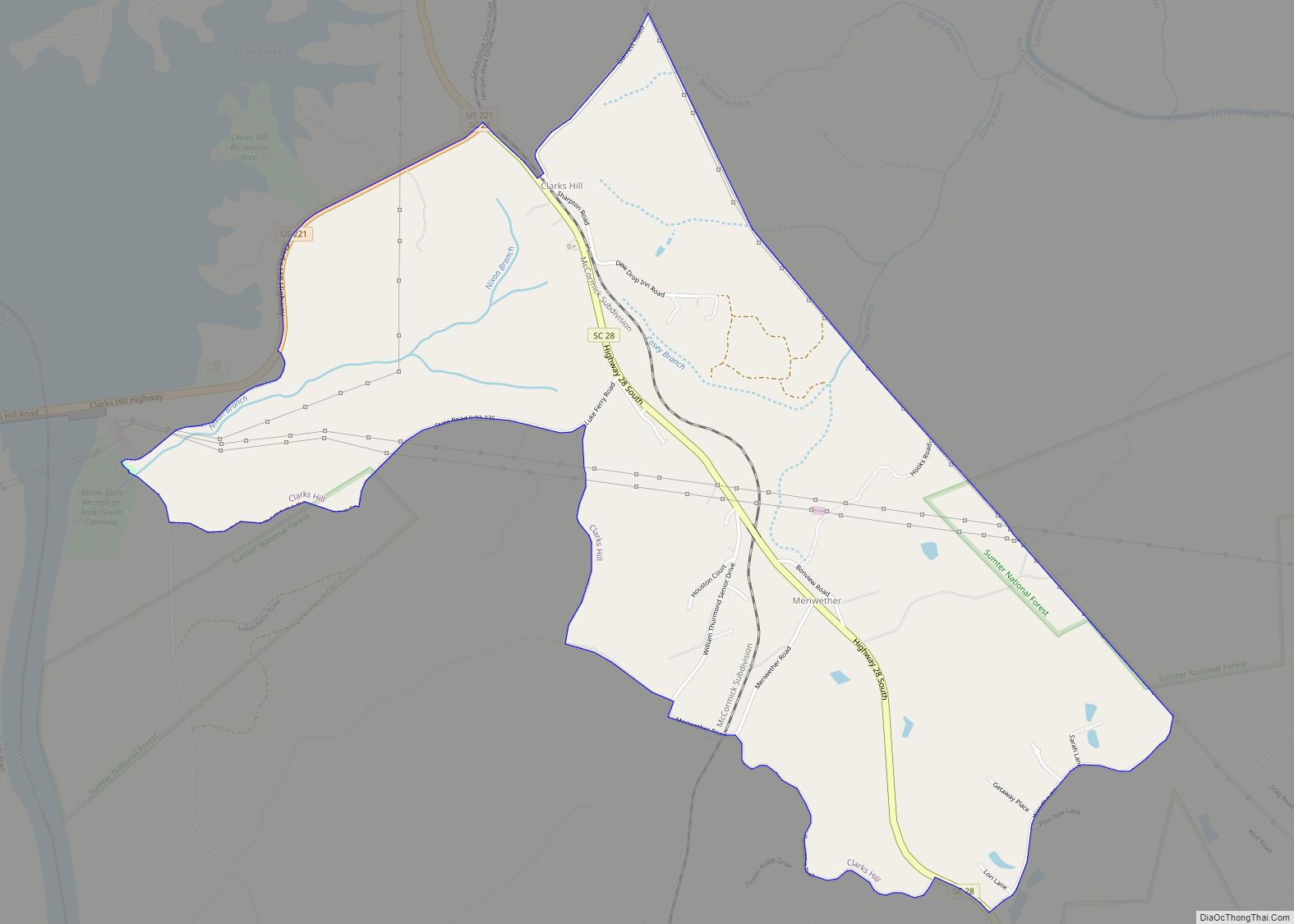
Map of Clio town, South Carolina

Map of Clio town, South Carolina

Clio (pronounced CLY-oh) is a town in Marlboro County, South Carolina, United States. The population was 726 at the 2010 census. Marlboro School of Discovery is a magnet school in Clio, South Carolina and is part of the Marlboro County School District. Clio town overview: Name: Clio town LSAD Code: 43 LSAD Description: town (suffix) … Read more

Map of Clinton city, South Carolina

Map of Clinton city, South Carolina

Clinton is a city in Laurens County, South Carolina, United States. The population was 8,490 as of the 2010 census. It is part of the Greenville–Mauldin–Easley Metropolitan Statistical Area in upstate South Carolina. Clinton is the home of Presbyterian College. Clinton city overview: Name: Clinton city LSAD Code: 25 LSAD Description: city (suffix) State: South … Read more

Map of Clifton CDP, South Carolina

Map of Clifton CDP, South Carolina

Clifton is a Census-designated place located in Spartanburg County in the U.S. State of South Carolina. According to the 2010 United States Census, the population was 541. Clifton CDP overview: Name: Clifton CDP LSAD Code: 57 LSAD Description: CDP (suffix) State: South Carolina County: Spartanburg County Elevation: 669 ft (204 m) Total Area: 1.14 sq mi (2.95 km²) Land Area: … Read more

Map of Dalzell CDP, South Carolina

Map of Dalzell CDP, South Carolina

Dalzell is a census-designated place (CDP) in Sumter County, South Carolina, United States. The population was 3,175 at the 2020 census. It is included in the Sumter, South Carolina Metropolitan Statistical Area. Dalzell CDP overview: Name: Dalzell CDP LSAD Code: 57 LSAD Description: CDP (suffix) State: South Carolina County: Sumter County Elevation: 217 ft (66 m) Total … Read more

Map of Cross Hill town

Map of Cross Hill town

Cross Hill is a town in Laurens County, South Carolina, United States. The population was 507 at the 2010 census. It is part of the Greenville–Mauldin–Easley Metropolitan Statistical Area. Cross Hill town overview: Name: Cross Hill town LSAD Code: 43 LSAD Description: town (suffix) State: South Carolina County: Laurens County Elevation: 587 ft (179 m) Total Area: … Read more

Map of Cross Anchor CDP

Map of Cross Anchor CDP

Cross Anchor is a Census-designated place in Spartanburg County, South Carolina, United States. The population in the 2010 United States Census was 126. Cross Anchor CDP overview: Name: Cross Anchor CDP LSAD Code: 57 LSAD Description: CDP (suffix) State: South Carolina County: Spartanburg County Elevation: 663 ft (202 m) Total Area: 0.78 sq mi (2.01 km²) Land Area: 0.77 sq mi (2.00 km²) … Read more

Map of Cowpens town

Map of Cowpens town

Cowpens is a town in Spartanburg County, South Carolina, United States. The population was 2,162 at the 2010 census. The town was founded in 1876, and was incorporated in 1880. Cowpens town overview: Name: Cowpens town LSAD Code: 43 LSAD Description: town (suffix) State: South Carolina County: Spartanburg County Elevation: 860 ft (262 m) Total Area: 2.29 sq mi … Read more

Map of Coward town

Map of Coward town

Coward is a town in Florence County, South Carolina, United States. The population was 752 at the 2010 census, up from 650 in 2000. It is part of the Florence Metropolitan Statistical Area. Coward town overview: Name: Coward town LSAD Code: 43 LSAD Description: town (suffix) State: South Carolina County: Florence County Elevation: 82 ft (25 m) … Read more

Map of Cottageville town

Map of Cottageville town

Cottageville is a town in Colleton County, South Carolina, United States. The population was 762 at the 2010 census. Cottageville town overview: Name: Cottageville town LSAD Code: 43 LSAD Description: town (suffix) State: South Carolina County: Colleton County Elevation: 46 ft (14 m) Total Area: 3.42 sq mi (8.85 km²) Land Area: 3.42 sq mi (8.85 km²) Water Area: 0.00 sq mi (0.00 km²) Total Population: … Read more

Map of Coronaca CDP

Map of Coronaca CDP

Coronaca is an unincorporated community and census-designated place (CDP) in Greenwood County, South Carolina, United States. The population was 191 at the 2010 census. Coronaca CDP overview: Name: Coronaca CDP LSAD Code: 57 LSAD Description: CDP (suffix) State: South Carolina County: Greenwood County Elevation: 558 ft (170 m) Total Area: 1.69 sq mi (4.36 km²) Land Area: 1.68 sq mi (4.35 km²) Water … Read more

Map of Cordova town, South Carolina

Map of Cordova town, South Carolina

Cordova is a town in Orangeburg County, South Carolina, United States. The population was 169 at the 2010 census. Despite its small size, Cordova is home to both a High School and a Primary School, a fire department, and a single Daycare. At the heart of Cordova is the town hall, which houses community events, … Read more

Map of Cope town

Map of Cope town

Cope is a town in Orangeburg County, South Carolina, United States. The population was 37 at the 2020 census, a decline from 77 in 2010. Cope town overview: Name: Cope town LSAD Code: 43 LSAD Description: town (suffix) State: South Carolina County: Orangeburg County Elevation: 197 ft (60 m) Total Area: 0.25 sq mi (0.65 km²) Land Area: 0.25 sq mi (0.65 km²) … Read more