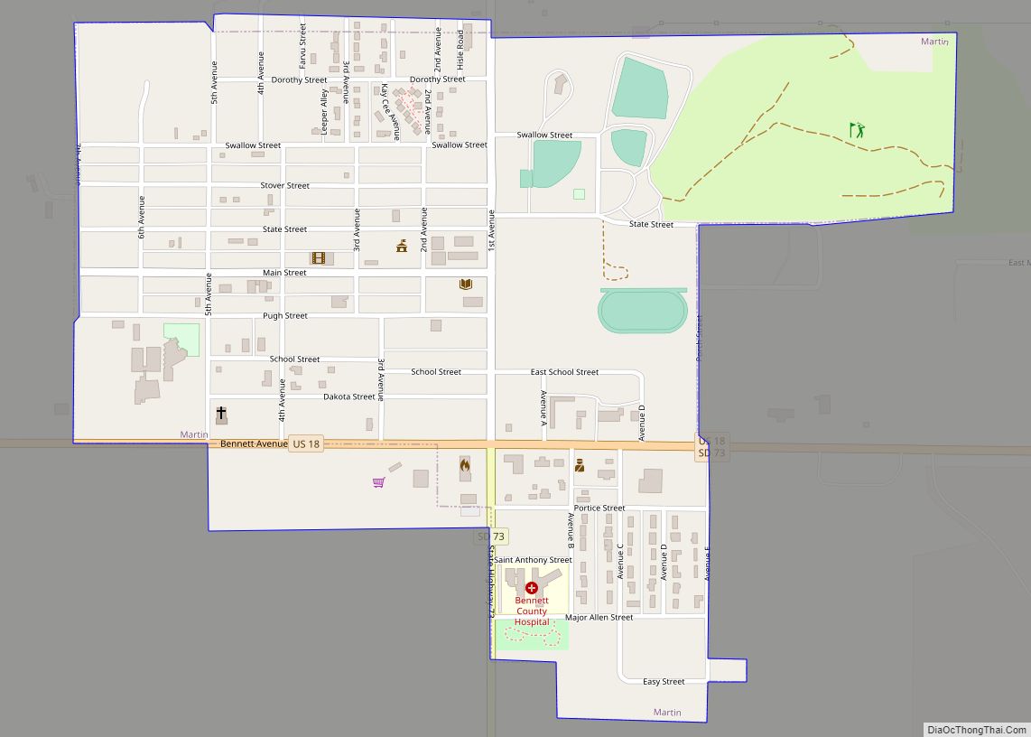
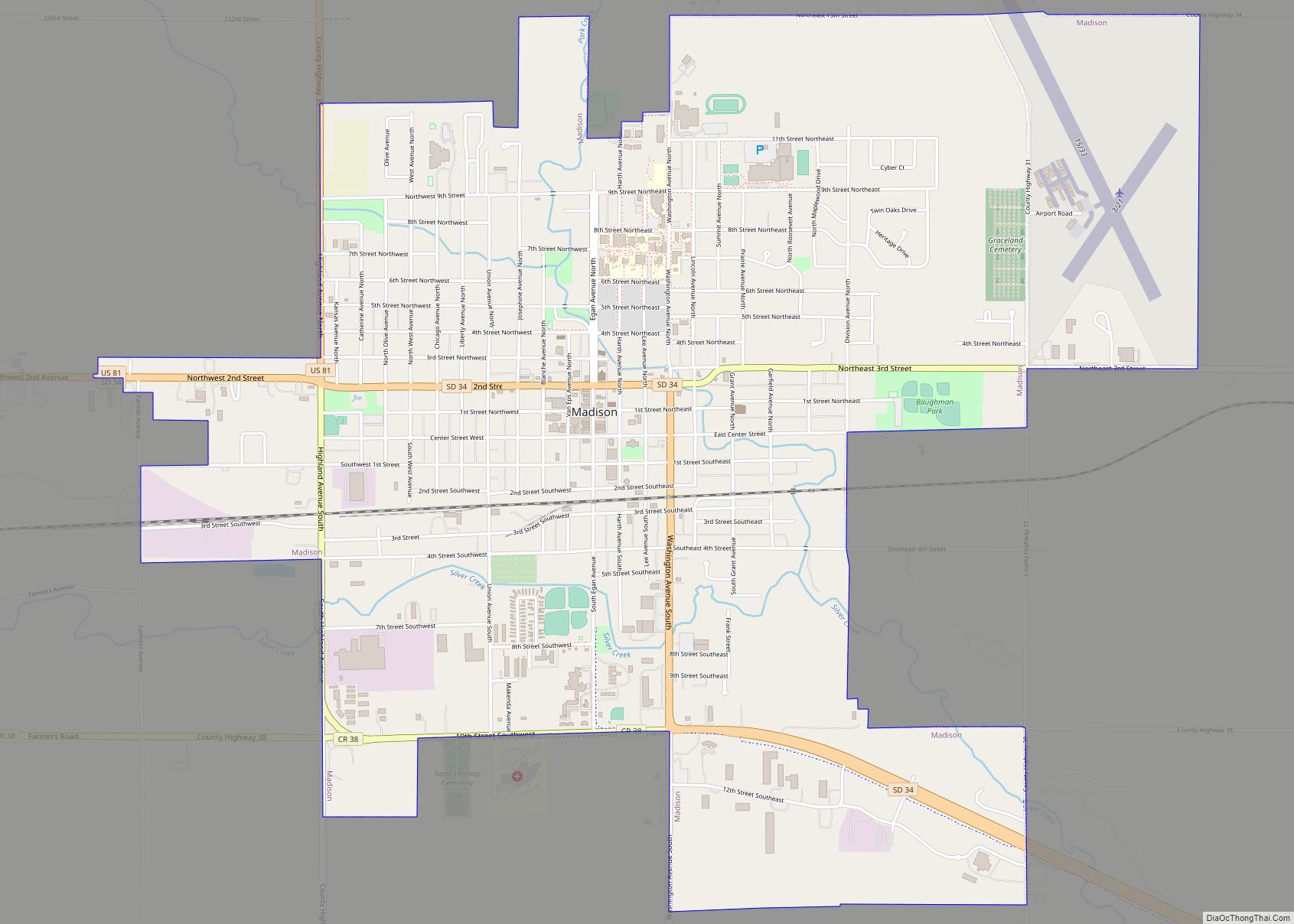
Map of Marion city, South Dakota

Map of Marion city, South Dakota

Marion is a city in Turner County, South Dakota, United States. The population was 849 at the 2020 census. Marion city overview: Name: Marion city LSAD Code: 25 LSAD Description: city (suffix) State: South Dakota County: Turner County Incorporated: 1881 Elevation: 1,450 ft (442 m) Total Area: 0.87 sq mi (2.25 km²) Land Area: 0.87 sq mi (2.25 km²) Water Area: 0.00 sq mi (0.00 km²) … Read more

Map of Mansfield CDP, South Dakota

Map of Mansfield CDP, South Dakota

Mansfield is an unincorporated community and census-designated place on the border between Brown and Spink counties, South Dakota, United States. The population was 86 according to the 2020 census. Located 2 miles (3 km) west of Highway 281, it is approximately 18 miles (29 km) south of Aberdeen, the third largest city in South Dakota. The James … Read more

Map of Manderson-White Horse Creek CDP

Map of Manderson-White Horse Creek CDP

Manderson-White Horse Creek (Lakota: oyúȟpe; the name of a band of the Oglala) is a census-designated place (CDP) in East Oglala Lakota Unorganized Territory (civil township equivalent) in Oglala Lakota County, South Dakota, United States. The population was 554 at the 2020 census. Oglala Lakota tribesman, Kicking Bear died here on May 28, 1904. He … Read more

Map of Madison city, South Dakota

Map of Madison city, South Dakota

Madison is a city in Lake County, South Dakota, United States. The population was 6,191 at the 2020 census. It is the county seat of Lake County and is home to Dakota State University. Madison city overview: Name: Madison city LSAD Code: 25 LSAD Description: city (suffix) State: South Dakota County: Lake County Founded: 1880 … Read more

Map of Lowry town, South Dakota

Map of Lowry town, South Dakota

Lowry is a town in Walworth County, South Dakota, United States. The population was 10 at the 2020 census. The town is home to Lowry Pilgrim Community Church, Swan Creek Harness Shop, J & C Repair, Karst Service (closed in August 2015) and a fire station. Lowry also has an abandoned school, and a post … Read more

Map of Lower Brule CDP

Map of Lower Brule CDP

Lower Brule (Lakota: Khulwíčhaša) is a census-designated place (CDP) in Lyman County, South Dakota, United States. The population was 703 at the 2020 census. The community is located within the Lower Brule Indian Reservation, from which it takes its name. Lower Brule CDP overview: Name: Lower Brule CDP LSAD Code: 57 LSAD Description: CDP (suffix) … Read more

Map of Loomis CDP, South Dakota

Map of Loomis CDP, South Dakota

Loomis is a census-designated place (CDP) in Davison County, South Dakota, United States. The population was 33 at the 2020 census. It is part of the Mitchell, South Dakota Micropolitan Statistical Area. Loomis was laid out in 1902. Loomis CDP overview: Name: Loomis CDP LSAD Code: 57 LSAD Description: CDP (suffix) State: South Dakota County: … Read more

Map of Long Lake town, South Dakota

Map of Long Lake town, South Dakota

Long Lake (Dakota: mdé háŋska; “lake long”) is a town in McPherson County, South Dakota, United States. The population was 27 at the 2020 census. The town took its name from the local Long Lake. Long Lake town overview: Name: Long Lake town LSAD Code: 43 LSAD Description: town (suffix) State: South Dakota County: McPherson … Read more

Map of Marty CDP

Map of Marty CDP

Marty is a census-designated place (CDP) in southern Charles Mix County, South Dakota, United States. The population was 677 at the 2020 census. The community has the name of Bishop Martin Marty, the Bishop of Sioux Falls, SD. The community is referred to as Ṡinasapa in Dakota language of the native Yankton Sioux Tribe. YST … Read more

Map of Milltown CDP, South Dakota

Map of Milltown CDP, South Dakota

Milltown is a census-designated place (CDP) in Hutchinson County, South Dakota, United States. The population was 8 at the 2020 census. Milltown was so named for the fact many of its early residents milled their supply of flour. Milltown CDP overview: Name: Milltown CDP LSAD Code: 57 LSAD Description: CDP (suffix) State: South Dakota County: … Read more

Map of Miller city, South Dakota

Map of Miller city, South Dakota

Miller is a city in and county seat of Hand County, South Dakota, United States. The population was 1,349 at the 2020 census. Miller city overview: Name: Miller city LSAD Code: 25 LSAD Description: city (suffix) State: South Dakota County: Hand County Incorporated: 1905 Elevation: 1,578 ft (481 m) Total Area: 0.99 sq mi (2.57 km²) Land Area: 0.99 sq mi (2.56 km²) … Read more

Map of Milbank city

Map of Milbank city

Milbank is a city in Grant County, South Dakota, United States, located along the South Fork of the Whetstone River. The population was 3,544 at the 2020 census. It is the county seat of Grant County. Milbank is the birthplace of American Legion Baseball. The program was created in Milbank in 1925 and is now … Read more