Map of Albee town
Albee is a town in Grant County, South Dakota, United States. The population was 7 at the 2020 census. Albee town overview: Name: Albee town LSAD Code: 43 LSAD Description: town (suffix) State: South Dakota County: Grant County Incorporated: 1902 Elevation: 1,181 ft (360 m) Total Area: 0.13 sq mi (0.34 km²) Land Area: 0.13 sq mi (0.34 km²) Water Area: 0.00 sq mi (0.00 km²) ... Read more
Map of Albee town
Map of Akaska town
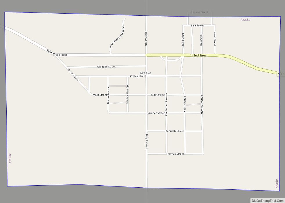
Akaska (/əˈkæskə/; ə-KAS-kə) is a town in Walworth County, South Dakota, United States. The population was 77 at the 2020 census. The community name derives from a Sioux word meaning “uncertain”. Akaska town overview: Name: Akaska town LSAD Code: 43 LSAD Description: town (suffix) State: South Dakota County: Walworth County Incorporated: 1907 Elevation: 1,778 ft (542 m) ... Read more
Map of Akaska town
Map of Agency Village CDP
Agency Village is an unincorporated area and census-designated place (CDP) in Roberts County, South Dakota, United States. It is the headquarters of the Sisseton Wahpeton Oyate and home to Sisseton Wahpeton College. Since 2020, the CDP includes the community known as Goodwill. The population of the CDP was 776 at the 2020 census. The village ... Read more
Map of Agency Village CDP
Map of Ashland Heights CDP
Ashland Heights is a census-designated place (CDP) and unincorporated community in Pennington County, South Dakota, United States. The population was 678 at the 2020 census. Ashland Heights CDP overview: Name: Ashland Heights CDP LSAD Code: 57 LSAD Description: CDP (suffix) State: South Dakota County: Pennington County Elevation: 3,166 ft (965 m) Total Area: 2.92 sq mi (7.56 km²) Land Area: ... Read more
Map of Ashland Heights CDP
Map of Artesian town
Artesian is a town in Sanborn County, South Dakota, United States. The population was 129 at the 2020 census. Artesian town overview: Name: Artesian town LSAD Code: 43 LSAD Description: town (suffix) State: South Dakota County: Sanborn County Incorporated: 1914 Elevation: 1,319 ft (402 m) Total Area: 0.55 sq mi (1.43 km²) Land Area: 0.55 sq mi (1.43 km²) Water Area: 0.00 sq mi (0.00 km²) ... Read more
Map of Artesian town
Map of Artas town
Artas is a town in Campbell County, South Dakota, United States. The population was 7 at the 2020 census. Artas town overview: Name: Artas town LSAD Code: 43 LSAD Description: town (suffix) State: South Dakota County: Campbell County Incorporated: 1951 Elevation: 1,821 ft (555 m) Total Area: 0.10 sq mi (0.27 km²) Land Area: 0.10 sq mi (0.27 km²) Water Area: 0.00 sq mi (0.00 km²) ... Read more
Map of Artas town
Map of Armour city
Armour is a city in county seat of Douglas County, South Dakota, United States. The population was 698 at the 2020 census. Armour city overview: Name: Armour city LSAD Code: 25 LSAD Description: city (suffix) State: South Dakota County: Douglas County Incorporated: 1904 Elevation: 1,529 ft (466 m) Total Area: 0.95 sq mi (2.47 km²) Land Area: 0.94 sq mi (2.45 km²) Water ... Read more
Map of Armour city
Map of Arlington city, South Dakota
Arlington is a city in Brookings and Kingsbury counties in the State of South Dakota. The population was 915 at the 2020 census. Arlington city overview: Name: Arlington city LSAD Code: 25 LSAD Description: city (suffix) State: South Dakota County: Brookings County, Kingsbury County Founded: 1880 Elevation: 1,844 ft (562 m) Total Area: 1.72 sq mi (4.45 km²) Land Area: ... Read more
Map of Arlington city, South Dakota
Map of Antelope CDP, South Dakota
Antelope is a census-designated place (CDP) in Todd County, South Dakota, United States. The population was 830 at the 2020 census. Antelope CDP overview: Name: Antelope CDP LSAD Code: 57 LSAD Description: CDP (suffix) State: South Dakota County: Todd County Total Area: 2.3 sq mi (5.9 km²) Land Area: 2.3 sq mi (5.9 km²) Water Area: 0 sq mi (0 km²) Total Population: 830 ... Read more
Map of Antelope CDP, South Dakota
Map of Andover town, South Dakota
Andover is a town in northwestern Day County, South Dakota, United States. The population was 66 at the 2020 census. Andover town overview: Name: Andover town LSAD Code: 43 LSAD Description: town (suffix) State: South Dakota County: Day County Incorporated: 1881 Elevation: 1,480 ft (451 m) Total Area: 0.27 sq mi (0.70 km²) Land Area: 0.27 sq mi (0.70 km²) Water Area: 0.00 sq mi ... Read more
Map of Andover town, South Dakota
Map of Aurora Center CDP
Aurora Center is a census-designated place (CDP) in Aurora County, South Dakota, United States. The population was 22 at the 2020 census. Aurora Center CDP overview: Name: Aurora Center CDP LSAD Code: 57 LSAD Description: CDP (suffix) State: South Dakota County: Aurora County Elevation: 1,647 ft (502 m) Total Area: 0.04 sq mi (0.11 km²) Land Area: 0.04 sq mi (0.11 km²) Water ... Read more
Map of Aurora Center CDP
Map of Astoria town, South Dakota
Astoria is a town in Deuel County, South Dakota, United States. The population was 132 at the 2020 census. Astoria town overview: Name: Astoria town LSAD Code: 43 LSAD Description: town (suffix) State: South Dakota County: Deuel County Incorporated: 1917 Elevation: 1,824 ft (556 m) Total Area: 0.16 sq mi (0.41 km²) Land Area: 0.16 sq mi (0.41 km²) Water Area: 0.00 sq mi (0.00 km²) ... Read more
Map of Astoria town, South Dakota