Map of East Cleveland CDP, Tennessee

Map of East Cleveland CDP, Tennessee

East Cleveland is a census-designated place (CDP) and community in Bradley County, Tennessee, United States. It is located directly east of the city limits of Cleveland, and is also considered one of the major divisions of the city. The population was 1,725 at the 2020 census. It is included in the Cleveland Metropolitan Statistical Area. … Read more

Map of Eagleville city, Tennessee

Map of Eagleville city, Tennessee

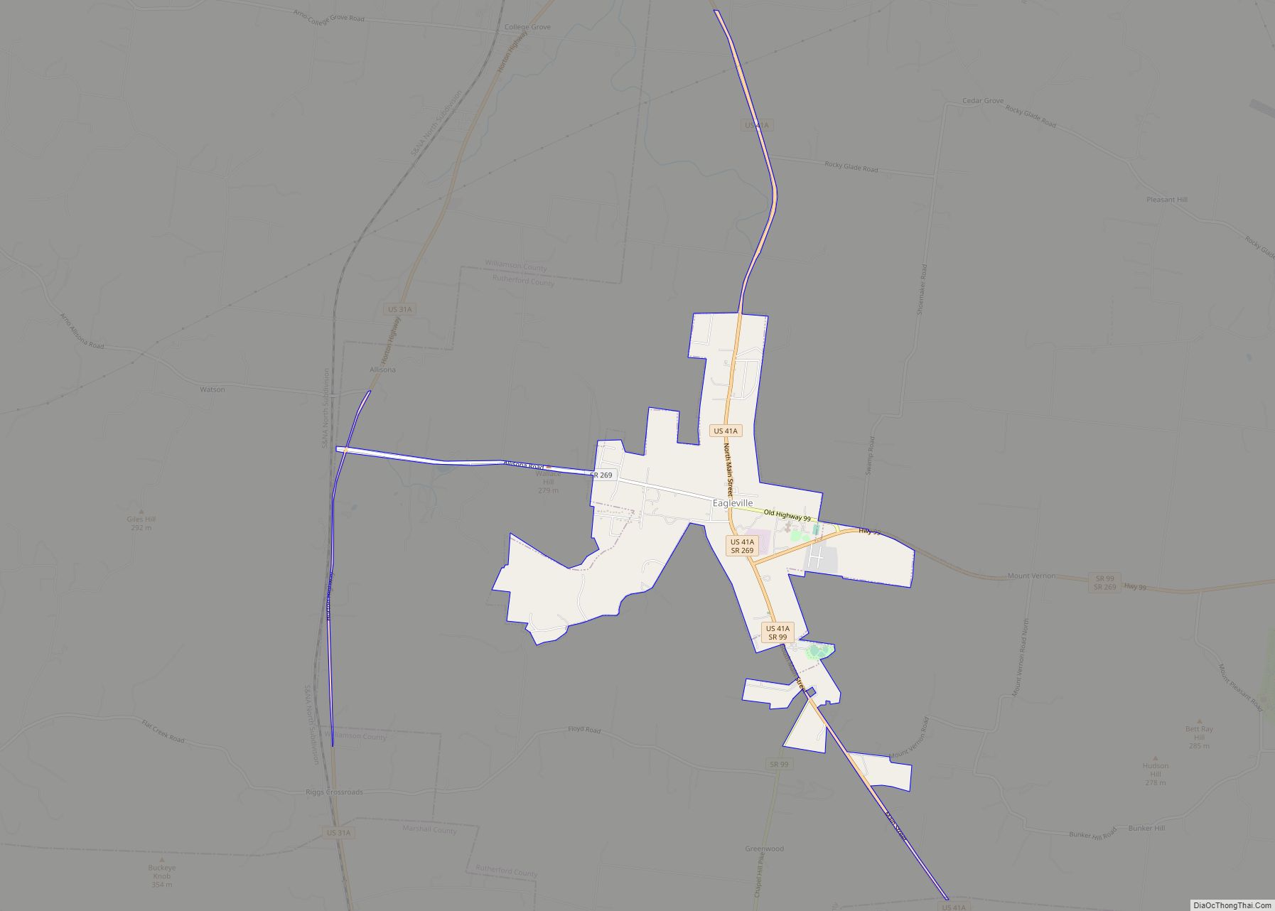
Eagleville is a city in Rutherford County, Tennessee. The population was 604 at the 2010 census. Eagleville city overview: Name: Eagleville city LSAD Code: 25 LSAD Description: city (suffix) State: Tennessee County: Rutherford County Founded: 1832 Incorporated: 1977 Elevation: 771 ft (235 m) Total Area: 2.88 sq mi (7.47 km²) Land Area: 2.88 sq mi (7.47 km²) Water Area: 0.00 sq mi (0.00 km²) Total Population: … Read more

Map of Eagleton Village CDP

Map of Eagleton Village CDP

Eagleton Village is a census-designated place (CDP) in Blount County, Tennessee, United States. The population was 5,052 at the 2010 census. It is included in the Knoxville, Tennessee Metropolitan Statistical Area. Eagleton Village CDP overview: Name: Eagleton Village CDP LSAD Code: 57 LSAD Description: CDP (suffix) State: Tennessee County: Blount County Elevation: 948 ft (289 m) Total … Read more

Map of Dyersburg city

Map of Dyersburg city

Dyersburg is a city and the county seat of Dyer County, Tennessee, United States. It is located in northwest Tennessee, 79 miles (127 km) northeast of Memphis on the Forked Deer River. The population was 16,164 at the 2020 census, down 5.72% from the 2010 census. Dyersburg city overview: Name: Dyersburg city LSAD Code: 25 LSAD … Read more

Map of Dyer city, Tennessee

Map of Dyer city, Tennessee

Dyer is a city in Gibson County, Tennessee, United States. The population was 2,341 at the 2010 census. Dyer was originally known as Dyer Station, a name given by railroad workers in the early days of rail. Dyer city overview: Name: Dyer city LSAD Code: 25 LSAD Description: city (suffix) State: Tennessee County: Gibson County … Read more

Map of Dunlap city, Tennessee

Map of Dunlap city, Tennessee

Dunlap is a city in and the county seat of Sequatchie County, Tennessee, United States. The population was 5,357 at the 2020 census and 4,815 at the 2010 census. Dunlap is part of the Chattanooga, TN–GA Metropolitan Statistical Area. Dunlap city overview: Name: Dunlap city LSAD Code: 25 LSAD Description: city (suffix) State: Tennessee County: … Read more

Map of Ducktown city

Map of Ducktown city

Ducktown (Cherokee: ᎦᏬᏅᏱ, romanized: Gawonvyi) is a city in Polk County, Tennessee, United States. The population was 461 at the 2020 census and 475 at the 2010 census. It is included in the Cleveland Metropolitan Statistical Area. Ducktown city overview: Name: Ducktown city LSAD Code: 25 LSAD Description: city (suffix) State: Tennessee County: Polk County Incorporated: … Read more

Map of Dresden town, Tennessee

Map of Dresden town, Tennessee

Dresden is a town in and the county seat of Weakley County, Tennessee, United States. The population was 3,005 at the 2010 census. Dresden town overview: Name: Dresden town LSAD Code: 43 LSAD Description: town (suffix) State: Tennessee County: Weakley County Elevation: 427 ft (130 m) Total Area: 5.96 sq mi (15.43 km²) Land Area: 5.94 sq mi (15.39 km²) Water Area: 0.02 sq mi … Read more

Map of Doyle town, Tennessee

Map of Doyle town, Tennessee

Doyle is a town in White County, Tennessee, United States. The population was 537 at the 2010 census. Doyle town overview: Name: Doyle town LSAD Code: 43 LSAD Description: town (suffix) State: Tennessee County: White County Incorporated: 1905 Elevation: 951 ft (290 m) Total Area: 1.24 sq mi (3.20 km²) Land Area: 1.24 sq mi (3.20 km²) Water Area: 0.00 sq mi (0.00 km²) Total Population: … Read more

Map of Dowelltown town

Map of Dowelltown town

Dowelltown is a town in DeKalb County, Tennessee, United States. The population was 355 at the 2010 census. Dowelltown town overview: Name: Dowelltown town LSAD Code: 43 LSAD Description: town (suffix) State: Tennessee County: DeKalb County Elevation: 577 ft (176 m) Total Area: 0.75 sq mi (1.95 km²) Land Area: 0.75 sq mi (1.95 km²) Water Area: 0.00 sq mi (0.00 km²) Total Population: 342 Population … Read more

Map of Estill Springs town

Map of Estill Springs town

Estill Springs is a town in Franklin County, Tennessee, United States. The population was 2,267 at the 2020 census. It is usually referred to simply as “Estill” by its inhabitants. Estill Springs is part of the Tullahoma, Tennessee, Micropolitan Statistical Area and is located in Middle Tennessee. Estill Springs town overview: Name: Estill Springs town … Read more

Map of Erwin town, Tennessee

Map of Erwin town, Tennessee

Erwin is a town in and the county seat of Unicoi County, Tennessee, United States. The population was 6,097 at the 2010 census. It is part of the Johnson City Metropolitan Statistical Area, which is a component of the Johnson City–Kingsport–Bristol, TN-VA Combined Statistical Area – commonly known as the “Tri-Cities” region. Erwin town overview: … Read more