Map of Erwin town, Tennessee
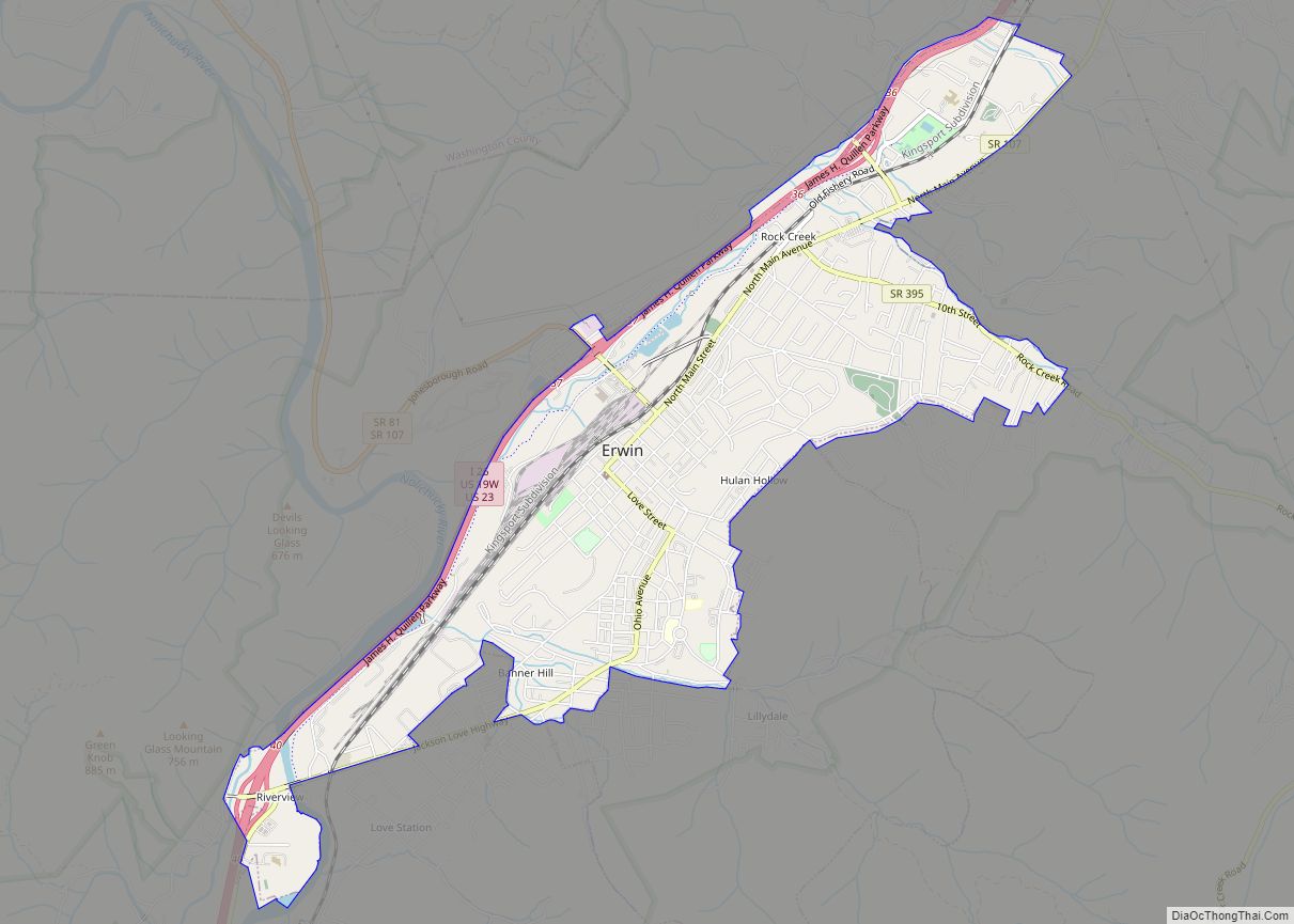
Erwin is a town in and the county seat of Unicoi County, Tennessee, United States. The population was 6,097 at the 2010 census. It is part of the Johnson City Metropolitan Statistical Area, which is a component of the Johnson City–Kingsport–Bristol, TN-VA Combined Statistical Area – commonly known as the “Tri-Cities” region. Erwin town overview: ... Read more
Map of Erwin town, Tennessee
Map of Erin city, Tennessee
Erin is a city in and the county seat of Houston County, Tennessee. The population was 1,224 at the time of the 2020 census and 1,324 at the time of the 2010 census. Erin city overview: Name: Erin city LSAD Code: 25 LSAD Description: city (suffix) State: Tennessee County: Houston County Elevation: 480 ft (146 m) Total ... Read more
Map of Erin city, Tennessee
Map of Enville town
Enville is a town in Chester and McNairy counties, Tennessee. The population was 230 at the 2000 census and 189 in 2010. Enville town overview: Name: Enville town LSAD Code: 43 LSAD Description: town (suffix) State: Tennessee County: Chester County, McNairy County Elevation: 420 ft (128 m) Total Area: 1.45 sq mi (3.74 km²) Land Area: 1.45 sq mi (3.74 km²) Water Area: ... Read more
Map of Enville town
Map of Englewood town, Tennessee
Englewood is a town in McMinn County, Tennessee, United States. The population was 1,550 in 2020. Englewood town overview: Name: Englewood town LSAD Code: 43 LSAD Description: town (suffix) State: Tennessee County: McMinn County Incorporated: 1919 Elevation: 860 ft (262 m) Total Area: 1.91 sq mi (4.95 km²) Land Area: 1.91 sq mi (4.95 km²) Water Area: 0.00 sq mi (0.00 km²) Total Population: 1,550 Population ... Read more
Map of Englewood town, Tennessee
Map of Elkton city, Tennessee
Elkton is a city in Giles County, Tennessee, United States. The population was 578 at the 2010 census. Elkton city overview: Name: Elkton city LSAD Code: 25 LSAD Description: city (suffix) State: Tennessee County: Giles County Elevation: 656 ft (200 m) Total Area: 1.99 sq mi (5.16 km²) Land Area: 1.99 sq mi (5.16 km²) Water Area: 0.00 sq mi (0.00 km²) Total Population: 545 Population ... Read more
Map of Elkton city, Tennessee
Map of Elizabethton city
Elizabethton is a city in, and the county seat of Carter County, Tennessee, United States. Elizabethton is the historical site of the first independent American government (known as the Watauga Association, created in 1772) located west of both the Eastern Continental Divide and the original Thirteen Colonies. The city is also the historical site of ... Read more
Map of Elizabethton city
Map of Elgin CDP, Tennessee
Elgin is a census-designated place and unincorporated community in Scott County, Tennessee, United States. Its population was 282 as of the 2010 census. Elgin has a post office with ZIP code 37732, which opened on January 14, 1891. Elgin CDP overview: Name: Elgin CDP LSAD Code: 57 LSAD Description: CDP (suffix) State: Tennessee County: Scott ... Read more
Map of Elgin CDP, Tennessee
Map of Eastview town
Eastview is a town in McNairy County, Tennessee. The population was 705 at the 2010 census. Eastview town overview: Name: Eastview town LSAD Code: 43 LSAD Description: town (suffix) State: Tennessee County: McNairy County Elevation: 522 ft (159 m) Total Area: 5.12 sq mi (13.26 km²) Land Area: 5.12 sq mi (13.26 km²) Water Area: 0.00 sq mi (0.00 km²) Total Population: 763 Population Density: 149.08/sq mi ... Read more
Map of Eastview town
Map of Fairmount CDP, Tennessee
Fairmount is a census-designated place (CDP) in Hamilton County, Tennessee, United States. The population was 2,193 at the 2020 census, down from 2,825 at the 2010 census. It is part of the Chattanooga, TN–GA Metropolitan Statistical Area. Fairmont is located within the town of Signal Mountain‘s zip code, 37377, along with the town of Walden ... Read more
Map of Fairmount CDP, Tennessee
Map of Fairgarden CDP
Fairgarden is a census-designated place in Sevier County, Tennessee, United States. Its population was 529 as of the 2010 census. Fairgarden CDP overview: Name: Fairgarden CDP LSAD Code: 57 LSAD Description: CDP (suffix) State: Tennessee County: Sevier County Elevation: 1,640 ft (500 m) Total Area: 1.73 sq mi (4.48 km²) Land Area: 1.73 sq mi (4.48 km²) Water Area: 0.00 sq mi (0.00 km²) Total Population: ... Read more
Map of Fairgarden CDP
Map of Fairfield CDP, Tennessee
Fairfield is a census-designated place and unincorporated community in Sumner County, Tennessee, United States. Its population was 131 as of the 2010 census. Fairfield CDP overview: Name: Fairfield CDP LSAD Code: 57 LSAD Description: CDP (suffix) State: Tennessee County: Sumner County Elevation: 810 ft (250 m) Total Area: 0.991 sq mi (2.57 km²) Land Area: 0.991 sq mi (2.57 km²) Water Area: 0 sq mi ... Read more
Map of Fairfield CDP, Tennessee
Map of Fairfield Glade CDP
Fairfield Glade is a resort, retirement community and census-designated place (CDP) in Cumberland County, Tennessee, United States. The population was 9,152 at the 2020 census, up over 3,000 from the 2010 census. Fairfield Glade CDP overview: Name: Fairfield Glade CDP LSAD Code: 57 LSAD Description: CDP (suffix) State: Tennessee County: Cumberland County Elevation: 2,087 ft (636 m) ... Read more
Map of Fairfield Glade CDP