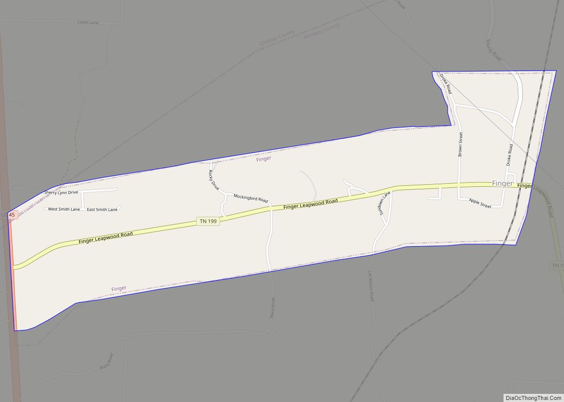
Map of Farragut town, Tennessee
Farragut is a suburban town located in Knox and Loudon counties in the State of Tennessee, United States. The town’s population was 23,506 at the 2020 census. It is included in the Knoxville Metropolitan Area. The town is named in honor of Hispanic American and Union Admiral David Farragut, who was born just east of ... Read more
Map of Farragut town, Tennessee
Map of Friendsville city, Tennessee
Friendsville is a city in Blount County, Tennessee, United States. Its population was 890 at the 2000 census and 913 at the 2010 census. It is included in the Knoxville, Tennessee Metropolitan Statistical Area. Friendsville city overview: Name: Friendsville city LSAD Code: 25 LSAD Description: city (suffix) State: Tennessee County: Blount County Incorporated: 1953 Elevation: ... Read more
Map of Friendsville city, Tennessee
Map of Friendship city, Tennessee
Friendship is a city in Crockett County, Tennessee. The population was 668 at the 2010 census. Also used to be the location of Friendship High School before it was closed for consolidation Friendship city overview: Name: Friendship city LSAD Code: 25 LSAD Description: city (suffix) State: Tennessee County: Crockett County Elevation: 400 ft (122 m) Total Area: ... Read more
Map of Friendship city, Tennessee
Map of Franklin city, Tennessee
Franklin is a city in and county seat of Williamson County, Tennessee, United States. About 21 miles (34 km) south of Nashville, it is one of the principal cities of the Nashville metropolitan area and Middle Tennessee. As of 2020, its population was 83,454. It is the seventh-largest city in Tennessee. Franklin is known to be ... Read more
Map of Franklin city, Tennessee
Map of Gilt Edge city
Gilt Edge is a city in Tipton County, Tennessee. The population was 477 at the 2010 census and 456 in 2018, showing a decrease of 21. Gilt Edge city overview: Name: Gilt Edge city LSAD Code: 25 LSAD Description: city (suffix) State: Tennessee County: Tipton County Elevation: 272 ft (83 m) Total Area: 2.75 sq mi (7.12 km²) Land Area: ... Read more
Map of Gilt Edge city
Map of Gibson town, Tennessee
Gibson is a town in Gibson County, Tennessee, United States. The population was 396 at the 2010 census. Gibson town overview: Name: Gibson town LSAD Code: 43 LSAD Description: town (suffix) State: Tennessee County: Gibson County Elevation: 404 ft (123 m) Total Area: 0.61 sq mi (1.58 km²) Land Area: 0.61 sq mi (1.58 km²) Water Area: 0.00 sq mi (0.00 km²) Total Population: 366 Population ... Read more
Map of Gibson town, Tennessee
Map of Germantown city, Tennessee
Germantown is a city in Shelby County, Tennessee, United States. The population was 41,333 at the 2020 census. Germantown is a suburb of Memphis, bordering it to the east-southeast. Germantown was founded in 1841 by mostly German emigrants. The town hosts Festivals year round to celebrate their history and German Culture. In the city center ... Read more
Map of Germantown city, Tennessee
Map of Gatlinburg city
Gatlinburg is a mountain resort city in Sevier County, Tennessee, United States. It is located 39 miles (63 km) southeast of Knoxville and had a population of 3,944 at the 2010 Census and a U.S. Census population of 3,577 in 2020. It is a popular vacation resort, as it rests on the border of Great Smoky ... Read more
Map of Gatlinburg city
Map of Gates town, Tennessee
Gates is a town in Lauderdale County, Tennessee, United States. The population was 901 at the 2000 census and 647 at the 2010 census, showing a decline of 254. Gates town overview: Name: Gates town LSAD Code: 43 LSAD Description: town (suffix) State: Tennessee County: Lauderdale County Elevation: 312 ft (95 m) Total Area: 0.70 sq mi (1.83 km²) Land ... Read more
Map of Gates town, Tennessee
Map of Garland town, Tennessee
Garland is a town in Tipton County, Tennessee. The population was 310 at the 2010 census. Garland town overview: Name: Garland town LSAD Code: 43 LSAD Description: town (suffix) State: Tennessee County: Tipton County Elevation: 354 ft (108 m) Total Area: 0.54 sq mi (1.41 km²) Land Area: 0.54 sq mi (1.41 km²) Water Area: 0.00 sq mi (0.00 km²) Total Population: 289 Population Density: 531.25/sq mi ... Read more
Map of Garland town, Tennessee
Map of Gallaway city
Gallaway is a city in Fayette County, Tennessee, United States. The population was 680 at the 2010 census. Gallaway city overview: Name: Gallaway city LSAD Code: 25 LSAD Description: city (suffix) State: Tennessee County: Fayette County Elevation: 282 ft (86 m) Total Area: 5.30 sq mi (13.72 km²) Land Area: 5.30 sq mi (13.72 km²) Water Area: 0.00 sq mi (0.00 km²) Total Population: 528 Population ... Read more
Map of Gallaway city
Map of Gallatin city, Tennessee
Gallatin is a city in and the county seat of Sumner County, Tennessee. The population was 30,278 at the 2010 census and 44,431 at the 2020 census. Named for United States Secretary of the Treasury Albert Gallatin, the city was established on the Cumberland River and made the county seat of Sumner County in 1802. ... Read more
Map of Gallatin city, Tennessee