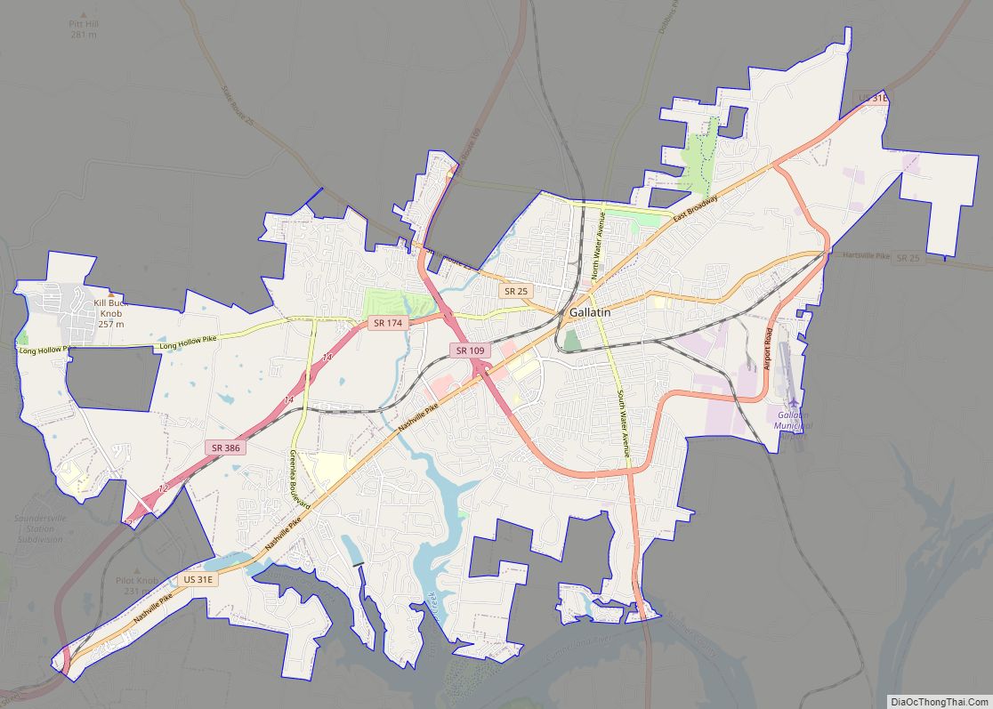
Map of Gainesboro town

Map of Gainesboro town

Gainesboro is a town in Jackson County, Tennessee, United States. The population was 920 at the 2020 census. It is the county seat of Jackson County. Gainesboro is part of the Cookeville, Tennessee Micropolitan Statistical Area. Gainesboro town overview: Name: Gainesboro town LSAD Code: 43 LSAD Description: town (suffix) State: Tennessee County: Jackson County Incorporated: … Read more

Map of Gadsden town, Tennessee

Map of Gadsden town, Tennessee

Gadsden is a town in Crockett County, Tennessee, United States. The population was 470 at the 2010 census. It is the birthplace of Hall of Fame rock guitarist Scotty Moore, who played with Elvis Presley and Ricky Nelson. Gadsden town overview: Name: Gadsden town LSAD Code: 43 LSAD Description: town (suffix) State: Tennessee County: Crockett … Read more

Map of Gordonsville town

Map of Gordonsville town, Tennessee

Gordonsville is a town in Smith County, Tennessee, United States. The population was 1,213 at the 2010 census. Gordonsville town overview: Name: Gordonsville town LSAD Code: 43 LSAD Description: town (suffix) State: Tennessee County: Smith County Incorporated: 1909 Elevation: 538 ft (164 m) Total Area: 7.16 sq mi (18.55 km²) Land Area: 7.11 sq mi (18.42 km²) Water Area: 0.05 sq mi (0.13 km²) Total Population: … Read more

Map of Goodlettsville city

Map of Goodlettsville city

Goodlettsville is a city in Davidson and Sumner counties, Tennessee. Goodlettsville was incorporated as a city in 1958 with a population of just over 3,000 residents; at the 2010 census, the city had a total population of 15,921 and in 2020 the population was 17,789. The northern half of the city is in Sumner County, … Read more

Map of Gleason town

Map of Gleason town

Gleason is a town in Weakley County, Tennessee, United States. The population was 1,445 at the 2010 census. The city also holds the annual Tater Town Parade and festival in the fall, and the Hometown Christmas event. The Ladies High School basketball team, the Lady Bulldogs, won the State Championship in 1992, 1999 and 2007. … Read more

Map of Greenbrier town, Tennessee

Map of Greenbrier town, Tennessee

Greenbrier is a city in Robertson County, Tennessee, United States. The population was 6,433 at the 2010 census, and at the 2020 census the population was 6,898. Greenbrier town overview: Name: Greenbrier town LSAD Code: 43 LSAD Description: town (suffix) State: Tennessee County: Robertson County Elevation: 850 ft (260 m) Total Area: 7.30 sq mi (18.90 km²) Land Area: 7.26 sq mi … Read more

Map of Greenback city

Map of Greenback city

Greenback is a city in Loudon County, Tennessee, United States. Its population was at 1,102, according to the 2020 census. It is included in the Knoxville Metropolitan Statistical Area. Greenback city overview: Name: Greenback city LSAD Code: 25 LSAD Description: city (suffix) State: Tennessee County: Loudon County Founded: 1883 Incorporated: 1957 Elevation: 899 ft (274 m) Total … Read more

Map of Green Hill CDP

Map of Green Hill CDP

Green Hill is a census-designated place (CDP) in western Wilson County, Tennessee. The population was 6,618 at the 2010 census. Green Hill CDP overview: Name: Green Hill CDP LSAD Code: 57 LSAD Description: CDP (suffix) State: Tennessee County: Wilson County Elevation: 646 ft (197 m) Total Area: 3.70 sq mi (9.59 km²) Land Area: 3.48 sq mi (9.00 km²) Water Area: 0.23 sq mi (0.59 km²) … Read more

Map of Graysville town, Tennessee

Map of Graysville town, Tennessee

Graysville is a town in Rhea County, Tennessee, United States. The population was 1,471 at the 2020 census and 1,502 at the 2010 census. Graysville town overview: Name: Graysville town LSAD Code: 43 LSAD Description: town (suffix) State: Tennessee County: Rhea County Elevation: 748 ft (228 m) Total Area: 1.18 sq mi (3.05 km²) Land Area: 1.18 sq mi (3.05 km²) Water Area: … Read more

Map of Gray CDP, Tennessee

Map of Gray CDP, Tennessee

Gray is a census-designated place (CDP) in Washington County, Tennessee, United States and a suburb of Johnson City. It is part of the Johnson City Metropolitan Statistical Area, which is a component of the Johnson City–Kingsport–Bristol, TN-VA Combined Statistical Area – commonly known as the “Tri-Cities” region. The population was 1,222 at the 2010 census. … Read more

Map of Grand Junction city, Tennessee

Map of Grand Junction city, Tennessee

Grand Junction is a city between the border of Hardeman and Fayette County, Tennessee, United States. The population was 325 at the 2010 census, and was estimated to be 303 in 2015. It has been called the “Bird Dog Capital of the World” and serves as the location of the National Bird Dog Museum. Grand … Read more

Map of Graball CDP

Map of Graball CDP

Graball is a census-designated place and unincorporated community in Sumner County, Tennessee, United States. Its population was 236 as of the 2010 census. Graball CDP overview: Name: Graball CDP LSAD Code: 57 LSAD Description: CDP (suffix) State: Tennessee County: Sumner County Elevation: 932 ft (284 m) Total Area: 2.006 sq mi (5.20 km²) Land Area: 2.006 sq mi (5.20 km²) Water Area: 0 sq mi … Read more