Map of Clint town
Clint is a town in El Paso County, Texas, United States. The population was 926 at the 2010 census. It is part of the El Paso Metropolitan Statistical Area. Clint town overview: Name: Clint town LSAD Code: 43 LSAD Description: town (suffix) State: Texas County: El Paso County Elevation: 3,638 ft (1,109 m) Total Area: 1.97 sq mi (5.11 km²) ... Read more
Map of Clint town
Map of Clifton city, Texas
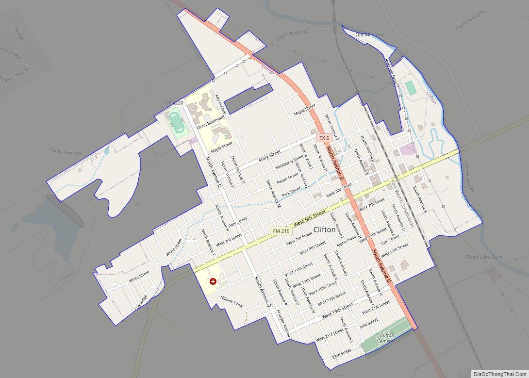
Clifton is the largest city in Bosque County, in Central Texas in the United States. The city’s population was 3,442 at the 2010 census. Clifton city overview: Name: Clifton city LSAD Code: 25 LSAD Description: city (suffix) State: Texas County: Bosque County Elevation: 673 ft (205 m) Total Area: 2.06 sq mi (5.34 km²) Land Area: 2.05 sq mi (5.31 km²) Water Area: ... Read more
Map of Clifton city, Texas
Map of Cleveland city, Texas
Cleveland is a city in the U.S. state of Texas, within Greater Houston metropolitan area and Liberty County. The population was 7,471 at the 2020 census. Cleveland city overview: Name: Cleveland city LSAD Code: 25 LSAD Description: city (suffix) State: Texas County: Liberty County, Montgomery County Incorporated: 1935 Elevation: 150 ft (45.7 m) Total Area: 18.99 sq mi (49.19 km²) Land ... Read more
Map of Cleveland city, Texas
Map of Cleburne city
Cleburne (/ˈkliːbɜːrn/ KLEE-burn) is a city in and the county seat of Johnson County, Texas, United States. As of the 2010 census, its population was 29,337. The city is named in honor of Patrick Cleburne, a Confederate general. Lake Pat Cleburne, the reservoir that provides water to the city and surrounding area, is also named ... Read more
Map of Cleburne city
Map of Clear Lake Shores city
Clear Lake Shores is a city in Galveston County, Texas, within the Houston–Sugar Land–Baytown metropolitan area. As of the 2010 census, the city population was 1,063. Clear Lake Shores city overview: Name: Clear Lake Shores city LSAD Code: 25 LSAD Description: city (suffix) State: Texas County: Galveston County Elevation: 10 ft (3 m) Total Area: 0.71 sq mi (1.85 km²) ... Read more
Map of Clear Lake Shores city
Map of Claude city
Claude is a city in and the county seat of Armstrong County, Texas, United States. The population was 1,196 at the 2010 census. It is located east of Amarillo in the south Texas Panhandle. Claude is part of the Amarillo Metropolitan Statistical Area but is some thirty miles east of Amarillo. Claude city overview: Name: ... Read more
Map of Claude city
Map of Collinsville town, Texas
Collinsville is a town in Grayson County, Texas, United States. Its population was 1,624 at the 2010 census, up from 1,235 at the 2000 census. It is part of the Sherman–Denison metropolitan statistical area. Collinsville is located on U.S. Route 377 south of Whitesboro. Collinsville town overview: Name: Collinsville town LSAD Code: 43 LSAD Description: ... Read more
Map of Collinsville town, Texas
Map of Colleyville city
Colleyville is a city in northeastern Tarrant County, Texas, United States, centrally located in the Dallas–Fort Worth metroplex. A wealthy suburb of the Dallas/Fort Worth area, Colleyville was originally a small farm town in the 19th century. The population was 22,807 at the 2010 census. Colleyville city overview: Name: Colleyville city LSAD Code: 25 LSAD ... Read more
Map of Colleyville city
Map of Coleman city, Texas
Coleman is a town in and the county seat of Coleman County, Texas, United States. As of the 2010 census, its population was 4,709. Coleman city overview: Name: Coleman city LSAD Code: 25 LSAD Description: city (suffix) State: Texas County: Coleman County Elevation: 1,696 ft (517 m) Total Area: 6.18 sq mi (16.00 km²) Land Area: 6.14 sq mi (15.91 km²) Water Area: ... Read more
Map of Coleman city, Texas
Map of Coldspring city
Coldspring is a city in San Jacinto County, Texas, United States. It is the county seat of San Jacinto County which is named after the river that traverses it and shares its name with the battle which gave Texas its independence. The population was 819 at the 2020 census. Coldspring city overview: Name: Coldspring city ... Read more
Map of Coldspring city
Map of Coffee City town
Coffee City is a small city in southeast Henderson County, Texas, United States. The population was 278 at the 2010 census, up from 193 at the 2000 census. The city was developed after the construction of Lake Palestine in the early 1960s. As it is located on a sliver of Henderson County, a wet county, ... Read more
Map of Coffee City town
Map of Cockrell Hill city
Cockrell Hill is a city in Dallas County, Texas, United States. The population was 4,193 at the 2010 census, and 3,815 in 2020. It is completely surrounded by the city of Dallas. Cockrell Hill city overview: Name: Cockrell Hill city LSAD Code: 25 LSAD Description: city (suffix) State: Texas County: Dallas County Elevation: 640 ft (195 m) ... Read more
Map of Cockrell Hill city