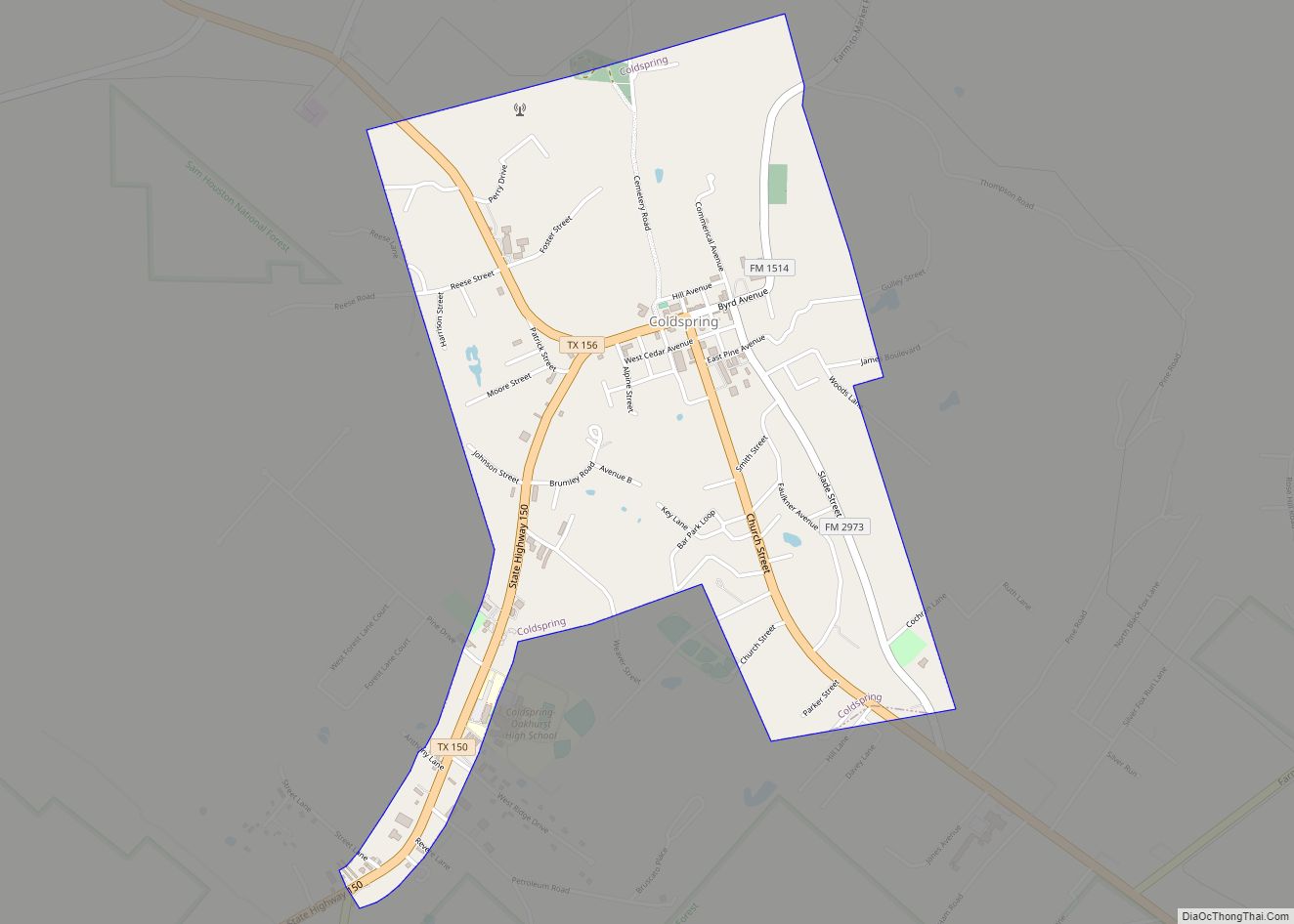
Map of Colorado Acres CDP

Map of Colorado Acres CDP

Colorado Acres is a census-designated place in Webb County, Texas, United States. The population was 296 at the 2010 census. This was a new CDP formed from parts of the Ranchitos Las Lomas CDP prior to the 2010 census. It is one of several colonias in the county. Colorado Acres CDP overview: Name: Colorado Acres … Read more

Map of Colmesneil city

Map of Colmesneil city

Colmesneil (/ˈkoʊlmɪsniːl/ KOHL-mis-neel) is a city in Tyler County, Texas, United States. It is located 9 miles north of Woodville on U.S. Highway 69. The population was 542 at the 2020 census. Colmesneil city overview: Name: Colmesneil city LSAD Code: 25 LSAD Description: city (suffix) State: Texas County: Tyler County Elevation: 272 ft (83 m) Total Area: … Read more

Map of Collinsville town, Texas

Map of Collinsville town, Texas

Collinsville is a town in Grayson County, Texas, United States. Its population was 1,624 at the 2010 census, up from 1,235 at the 2000 census. It is part of the Sherman–Denison metropolitan statistical area. Collinsville is located on U.S. Route 377 south of Whitesboro. Collinsville town overview: Name: Collinsville town LSAD Code: 43 LSAD Description: … Read more

Map of Colleyville city

Map of Colleyville city

Colleyville is a city in northeastern Tarrant County, Texas, United States, centrally located in the Dallas–Fort Worth metroplex. A wealthy suburb of the Dallas/Fort Worth area, Colleyville was originally a small farm town in the 19th century. The population was 22,807 at the 2010 census. Colleyville city overview: Name: Colleyville city LSAD Code: 25 LSAD … Read more

Map of Converse city, Texas

Map of Converse city, Texas

Converse is a city in Bexar County, Texas, United States, 15 miles (24 km) northeast of downtown San Antonio. As of the 2020 census, it had a population of 27,466. It is part of the San Antonio Metropolitan Statistical Area. In 2017, Converse proposed the annexation of 12 mi of territory near Randolph Air Force Base in … Read more

Map of Conroe city

Map of Conroe city

Conroe is a city in and the county seat of Montgomery County, Texas, United States, about 40 miles (64 km) north of Houston. It is a principal city in the Houston–The Woodlands–Sugar Land metropolitan area. As of 2021, the population was 98,081, up from 56,207 in 2010. Since 2007, the city has increased in size (and population) by … Read more

Map of Concepcion CDP

Map of Concepcion CDP

Concepcion (/kənˌsɛpsiˈoʊn/ kən-sep-see-OHN) is an unincorporated community and census-designated place (CDP) in Duval County, Texas, United States. The population was 62 at the 2010 census. Concepcion CDP overview: Name: Concepcion CDP LSAD Code: 57 LSAD Description: CDP (suffix) State: Texas County: Duval County Elevation: 302 ft (92 m) Total Area: 0.08 sq mi (0.2 km²) Land Area: 0.08 sq mi (0.2 km²) Water … Read more

Map of Como town, Texas

Map of Como town, Texas

Como is a town in Hopkins County, Texas, United States. The population was 702 at the 2010 census. Texas politician Marshall Formby was born in Como in 1911. Former State Representative Erwin Cain practices law in Sulphur Springs but resides in Como with his wife and three children. Como town overview: Name: Como town LSAD … Read more

Map of Commerce city, Texas

Map of Commerce city, Texas

Commerce is a city in Hunt County, Texas, United States, situated on the eastern edge of North Texas, in the heart of the Texas Blackland Prairies. The town is 45 miles (72 km) south of the Texas/Oklahoma border. Commerce is the second-largest city in Hunt County, with a population of 9,090 at the 2020 census. The … Read more

Map of Comfort CDP

Map of Comfort CDP, Texas

Comfort is an unincorporated community and census-designated place (CDP) in Kendall County, Texas, United States. As of the 2010 census it had a population of 2,363. Comfort was founded by German emigrants on the western end of the Texas-German belt. Many residents of the town today are descendants of those same Germans. Comfort is known … Read more

Map of Combine city

Map of Combine city

Combine is a city in Dallas and Kaufman counties in the U.S. state of Texas. The population was 2,245 in 2020. Combine city overview: Name: Combine city LSAD Code: 25 LSAD Description: city (suffix) State: Texas County: Dallas County, Kaufman County Elevation: 413 ft (126 m) Total Area: 7.58 sq mi (19.64 km²) Land Area: 7.28 sq mi (18.85 km²) Water Area: 0.30 sq mi … Read more

Map of Combes town

Map of Combes town

Combes is a town in northern Cameron County, Texas, United States. Its population was 2,895 at the 2010 census. It is part of the Brownsville–Harlingen–Raymondville and the Matamoros–Brownsville metropolitan areas. Combes town overview: Name: Combes town LSAD Code: 43 LSAD Description: town (suffix) State: Texas County: Cameron County Elevation: 39 ft (12 m) Total Area: 3.24 sq mi (8.39 km²) … Read more