Map of Fort Davis CDP

Map of Fort Davis CDP

Fort Davis is an unincorporated community and census-designated place (CDP) in Jeff Davis County, Texas, United States. The population was 1,201 at the 2010 census, up from 1,050 at the 2000 census. It is the county seat of Jeff Davis County. Fort Davis CDP overview: Name: Fort Davis CDP LSAD Code: 57 LSAD Description: CDP … Read more

Map of Fort Clark Springs CDP

Map of Fort Clark Springs CDP

Fort Clark Springs is an unincorporated community and census-designated place (CDP) in Kinney County, Texas, United States. The population was 1,228 at the 2010 census. It is the site of the former Fort Clark, now a historic district. Fort Clark Springs CDP overview: Name: Fort Clark Springs CDP LSAD Code: 57 LSAD Description: CDP (suffix) … Read more

Map of Fort Bliss CDP

Map of Fort Bliss CDP

Fort Bliss is a United States Army post in New Mexico and Texas, with its headquarters in El Paso, Texas. Named in honor of LTC William Bliss (1815–1853), a mathematics professor who was the son-in-law of President Zachary Taylor, Ft. Bliss has an area of about 1,700 square miles (4,400 km); it is the largest installation … Read more

Map of Forsan city

Map of Forsan city

Forsan is a city in Howard County, Texas, United States. The population was 210 at the 2010 census. Forsan city overview: Name: Forsan city LSAD Code: 25 LSAD Description: city (suffix) State: Texas County: Howard County Elevation: 2,789 ft (850 m) Total Area: 0.29 sq mi (0.75 km²) Land Area: 0.29 sq mi (0.75 km²) Water Area: 0.00 sq mi (0.00 km²) Total Population: 210 Population … Read more

Map of Forney city

Map of Forney city

Forney is a city in Kaufman County, Texas, United States, and has been named by the Texas Legislature as the “Antique Capital of Texas”. It is part of the Dallas–Fort Worth metroplex. Its population was 14,661 at the 2010 census, up from 5,588 at the 2000 census; in 2020, its population was 23,455. Forney city … Read more

Map of Forest Hill city, Texas

Map of Forest Hill city, Texas

Forest Hill is a suburb of Fort Worth in Tarrant County, Texas, United States. The population was 12,355 at the 2010 census. Forest Hill city overview: Name: Forest Hill city LSAD Code: 25 LSAD Description: city (suffix) State: Texas County: Tarrant County Elevation: 682 ft (208 m) Total Area: 4.17 sq mi (10.80 km²) Land Area: 4.17 sq mi (10.80 km²) Water Area: … Read more

Map of Follett city

Map of Follett city

Follett is a town in Lipscomb County, Texas, United States, which was established in 1917 by Santa Fe railroad official Thomas C. Spearman as a townsite on the North Texas and Santa Fe Railway. It was named for Horace Follett, a locating engineer for the line. The population was 459 at the 2010 census. Follett … Read more

Map of Fort Stockton city

Map of Fort Stockton city

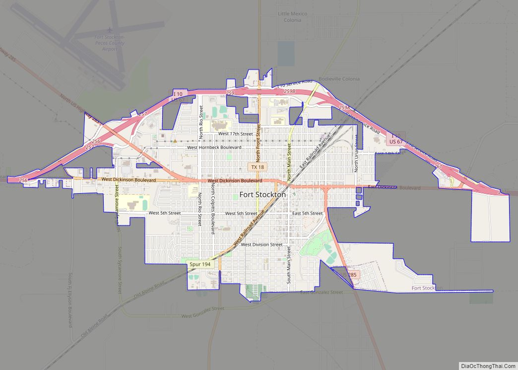
Fort Stockton is a city in and the county seat of Pecos County, Texas, United States. It is located on Interstate 10, future Interstate 14, U.S. Highways 67, 285, and 385, and the Santa Fe Railroad, 329 mi (529 km) northwest of San Antonio and 240 mi (390 km) southeast of El Paso. Its population was 8,283 at the … Read more

Map of Fort Hood CDP

Map of Fort Hood CDP

Fort Cavazos is a United States Army post located near Killeen, Texas. The post is named after Gen. Richard E. Cavazos, a native Texan and the US Army’s first Hispanic four-star general. Formerly named Fort Hood for Confederate General John Bell Hood, the post is located halfway between Austin and Waco, about 60 mi (97 km) from … Read more

Map of Fort Hancock CDP

Map of Fort Hancock CDP

Fort Hancock is an unincorporated community and census-designated place (CDP) in Hudspeth County, Texas, United States. Its population was 1,213 at the 2020: DEC Redistricting Data. Fort Hancock is situated on the Mexico–United States border, across from El Porvenir, Chihuahua. The Fort Hancock–El Porvenir International Bridge connects the two communities, and the Fort Hancock Port … Read more

Map of Friendswood city

Map of Friendswood city

Friendswood is a city in the U.S. state of Texas. It is part of the Houston–The Woodlands–Sugar Land metropolitan area. The city lies in Galveston and Harris Counties. As of the 2010 census, the population of Friendswood was 35,805. In 2007, CNN/Money magazine listed Friendswood as one of 100 “America’s Best Places to Live” for … Read more

Map of Fresno CDP, Texas

Map of Fresno CDP, Texas

Fresno is an unincorporated community and census-designated place (CDP) in Fort Bend County, Texas, United States. The local population was 24,486 as of the 2020 census, up from 19,069 at the 2010 census, and 6,603 at the 2000 census. Fresno is located in the extra-territorial jurisdiction (ETJ) of Houston, which is the fourth largest city … Read more