Map of Freeport city, Texas

Map of Freeport city, Texas

Freeport is a city in Brazoria County, Texas, United States, located on the Gulf of Mexico. According to the 2020 census, the city population was 10,696, down from 12,049 in 2010. Freeport city overview: Name: Freeport city LSAD Code: 25 LSAD Description: city (suffix) State: Texas County: Brazoria County Incorporated: February 10, 1917 Elevation: 5 ft … Read more

Map of Fredericksburg city, Texas

Map of Fredericksburg city, Texas

Fredericksburg (German: Friedrichsberg) is the seat of Gillespie County, in the U.S. state of Texas. As of the 2010 Census, this city had a population of 10,530. Fredericksburg was founded in 1846 and named after Prince Frederick of Prussia. Old-time German residents often referred to Fredericksburg as Fritztown, a nickname that is still used in … Read more

Map of Frankston town

Map of Frankston town

Frankston is a town in Anderson County, Texas, United States. With a population of 1,126 at the 2020 United States census, it is one of the most populous communities of the county area. Frankston town overview: Name: Frankston town LSAD Code: 43 LSAD Description: town (suffix) State: Texas County: Anderson County, Henderson County Elevation: 420 ft … Read more

Map of Franklin city, Texas

Map of Franklin city, Texas

Franklin is a city and the county seat of Robertson County, Texas, United States. It is within the Brazos Valley on the cusp of East and Central Texas. As of the 2020 census, the city population was 1,614. Franklin city overview: Name: Franklin city LSAD Code: 25 LSAD Description: city (suffix) State: Texas County: Robertson … Read more

Map of Fowlerton CDP, Texas

Map of Fowlerton CDP, Texas

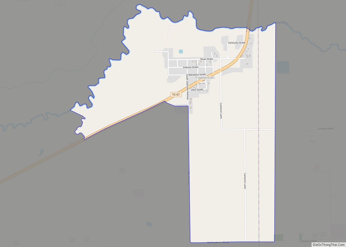
Fowlerton is a census-designated place (CDP) in La Salle County, Texas, United States. Its population was 55 at the 2010 census. Fowlerton CDP overview: Name: Fowlerton CDP LSAD Code: 57 LSAD Description: CDP (suffix) State: Texas County: La Salle County Elevation: 318 ft (97 m) Total Area: 2.18 sq mi (5.64 km²) Land Area: 2.17 sq mi (5.62 km²) Water Area: 0.004 sq mi (0.01 km²) … Read more

Map of Four Points CDP

Map of Four Points CDP

Four Points is a census-designated place (CDP) in Webb County, Texas, United States. This was a new CDP formed from parts of the Botines CDP prior to the 2010 census with a population of 18. It is one of several colonias in the county. Four Points CDP overview: Name: Four Points CDP LSAD Code: 57 … Read more

Map of Four Corners CDP, Texas

Map of Four Corners CDP, Texas

Four Corners is a census-designated place (CDP) within the extraterritorial jurisdiction of Houston in Fort Bend County, Texas, United States. The population was 12,103 at the 2020 census, up from 2,954 at the 2000 census. Four Corners CDP overview: Name: Four Corners CDP LSAD Code: 57 LSAD Description: CDP (suffix) State: Texas County: Fort Bend … Read more

Map of Friendswood city

Map of Friendswood city

Friendswood is a city in the U.S. state of Texas. It is part of the Houston–The Woodlands–Sugar Land metropolitan area. The city lies in Galveston and Harris Counties. As of the 2010 census, the population of Friendswood was 35,805. In 2007, CNN/Money magazine listed Friendswood as one of 100 “America’s Best Places to Live” for … Read more

Map of Gainesville city, Texas

Map of Gainesville city, Texas

Gainesville is a city in and the county seat of Cooke County, Texas, United States. Its population was 16,002 at the 2010 census. It is part of the Texoma region and is an important Agri-business center. Gainesville city overview: Name: Gainesville city LSAD Code: 25 LSAD Description: city (suffix) State: Texas County: Cooke County Elevation: … Read more

Map of Gail CDP

Map of Gail CDP

Gail is an unincorporated community in Borden County, Texas, United States. Located at the junction of U.S. Highway 180 and Farm to Market Road 669, it is the county seat of Borden County. As of the 2010 Census, the population was 231. The town and county are named for Gail Borden, Jr., the inventor of … Read more

Map of Fulton town, Texas

Map of Fulton town, Texas

Fulton is a town in Aransas County, Texas, United States. As of the 2010 census, this South Texas coastal fishing community had a population of 1,358. The town is named for George Ware Fulton, a land developer in the area. Fulton town overview: Name: Fulton town LSAD Code: 43 LSAD Description: town (suffix) State: Texas … Read more

Map of Fulshear city

Map of Fulshear city

Fulshear (/ˈfʊlʃər/ FUUL-shər) is a city in northwest Fort Bend County, Texas, United States, and is located on the western edge of the Houston–The Woodlands–Sugar Land metropolitan area. The population was 16,856 as of the 2020 census. Fulshear city overview: Name: Fulshear city LSAD Code: 25 LSAD Description: city (suffix) State: Texas County: Fort Bend … Read more