Map of Hackberry town, Texas

Map of Hackberry town, Texas

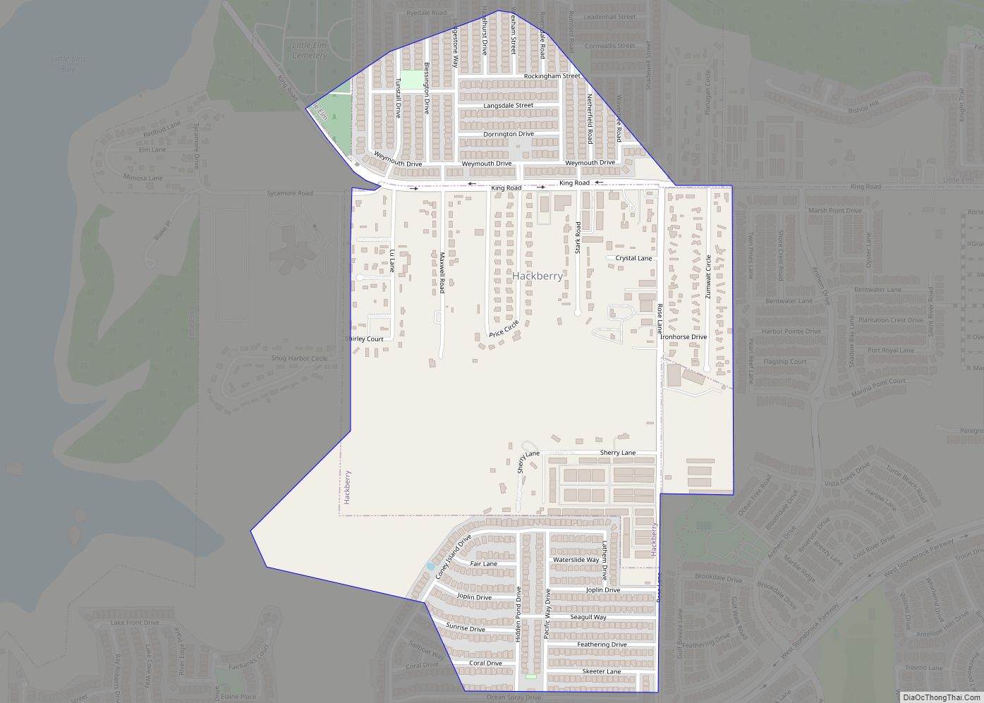
Hackberry is a town in Denton County, Texas, United States. The population was 2,973 in 2020. Hackberry town overview: Name: Hackberry town LSAD Code: 43 LSAD Description: town (suffix) State: Texas County: Denton County Elevation: 551 ft (168 m) Total Area: 0.68 sq mi (1.77 km²) Land Area: 0.68 sq mi (1.76 km²) Water Area: 0.00 sq mi (0.01 km²) Total Population: 2,973 Population Density: 1,586.16/sq mi … Read more

Map of H. Cuellar Estates CDP

Map of H. Cuellar Estates CDP

H. Cuellar Estates is a census-designated place (CDP) in Starr County, Texas, United States. It is a new CDP formed from part of the Falcon Heights CDP prior to the 2010 census. In the 2020 census, it had a population of 11, down from 20 in the 2010 census. H. Cuellar Estates CDP overview: Name: … Read more

Map of Gutierrez CDP

Map of Gutierrez CDP

Gutierrez is a census-designated place (CDP) in Starr County, Texas, United States. This was a new CDP for the 2010 census with a population of 79. Gutierrez CDP overview: Name: Gutierrez CDP LSAD Code: 57 LSAD Description: CDP (suffix) State: Texas County: Starr County Total Area: 0.1 sq mi (0.3 km²) Land Area: 0.1 sq mi (0.3 km²) Water Area: 0.0 sq mi … Read more

Map of Guthrie CDP, Texas

Map of Guthrie CDP, Texas

Guthrie is an unincorporated community and census-designated place (CDP) in, and the county seat of, King County in the U.S. state of Texas. It is in the northern part of the state, 93 miles (150 km) east of Lubbock. It serves as the principal headquarters of the Four Sixes Ranch. As of the 2010 census, its … Read more

Map of Harlingen city, Texas

Map of Harlingen city, Texas

Harlingen (/ˈhɑːrlɪndʒɪn/ HAR-lin-jin) is a city in Cameron County in the central region of the Rio Grande Valley of the southern part of the U.S. state of Texas, about 30 miles (48 km) from the coast of the Gulf of Mexico. The city covers more than 40 square miles (104 km) and is the second-largest city in … Read more

Map of Harker Heights city

Map of Harker Heights city

Harker Heights is a city in Bell County, Texas, United States. As of the 2020 census, 33,097 people resided in the city, up from a population of 17,308 in 2000. This makes Harker Heights the third-largest city in Bell County, after Killeen and Temple. Incorporated in 1960, the city derives its name from one of … Read more

Map of Hargill CDP

Map of Hargill CDP

Hargill is a census-designated place (CDP) in Hidalgo County, Texas, United States. As of the 2010 United States Census, it had a population of 877. Hargill is part of the McAllen–Edinburg–Mission Metropolitan Statistical Area. Hargill CDP overview: Name: Hargill CDP LSAD Code: 57 LSAD Description: CDP (suffix) State: Texas County: Hidalgo County FIPS code: 4832300 … Read more

Map of Hardin city, Texas

Map of Hardin city, Texas

Hardin is a city in Liberty County, Texas, United States. Its population was 768 at the 2020 census. Hardin city overview: Name: Hardin city LSAD Code: 25 LSAD Description: city (suffix) State: Texas County: Liberty County Elevation: 82 ft (25 m) Total Area: 2.59 sq mi (6.71 km²) Land Area: 2.59 sq mi (6.71 km²) Water Area: 0.00 sq mi (0.00 km²) Total Population: 768 Population … Read more

Map of Happy town

Map of Happy town

Happy is a town in Randall and Swisher Counties in the U.S. state of Texas. The population was 678 at the 2010 census. The Randall County portion of Happy is part of the Amarillo, Texas Metropolitan Statistical Area. Happy town overview: Name: Happy town LSAD Code: 43 LSAD Description: town (suffix) State: Texas County: Randall … Read more

Map of Hamlin city, Texas

Map of Hamlin city, Texas

Hamlin is a city in Jones and Fisher Counties in the U.S. state of Texas. The population was 2,124 at the 2010 census, and in 2018, the estimated population was 1,997. The Jones County portion of Hamlin is part of the Abilene, Texas metropolitan area. Hamlin city overview: Name: Hamlin city LSAD Code: 25 LSAD … Read more

Map of Hamilton city, Texas

Map of Hamilton city, Texas

Hamilton is a city in and the county seat of Hamilton County, Texas, United States, located in the state’s central region. Its population was 3,095 at the 2010 census. Hamilton city overview: Name: Hamilton city LSAD Code: 25 LSAD Description: city (suffix) State: Texas County: Hamilton County Elevation: 1,168 ft (356 m) Total Area: 3.53 sq mi (9.15 km²) Land … Read more

Map of Haltom City city

Map of Haltom City

Haltom City is a city, part of the Dallas–Fort Worth region, in Tarrant County, Texas, United States. Its population was 46,073 at the 2020 census. Haltom City is an inner suburb of Fort Worth, a principal city of the DFW Metroplex. The city is 6 miles from downtown Fort Worth, 30 miles from the American … Read more