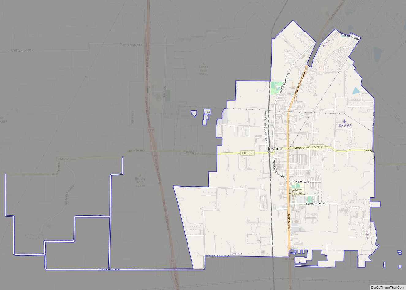
Map of Josephine city

Map of Josephine city

Josephine is a city in Collin and Hunt counties in the U.S. state of Texas. Its population was 812 at the 2010 census, with 755 residents in Collin County and 57 in Hunt County. By 2020, its population increased to 2,119. Josephine city overview: Name: Josephine city LSAD Code: 25 LSAD Description: city (suffix) State: … Read more

Map of Jonestown city, Texas

Map of Jonestown city, Texas

Jonestown is a city in Travis County, Texas, United States on the north shore of Lake Travis. The population was 2,365 at the 2020 census. Jonestown city overview: Name: Jonestown city LSAD Code: 25 LSAD Description: city (suffix) State: Texas County: Travis County Incorporated: 1985; 38 years ago (1985) Elevation: 814 ft (248 m) Total Area: 7.60 sq mi (19.68 km²) Land … Read more

Map of Kempner city

Map of Kempner city

Kempner is a city in Lampasas County, Texas, United States. The population was 1,146 at the 2020 census. It is part of the Killeen–Temple–Fort Hood Metropolitan Statistical Area. Kempner city overview: Name: Kempner city LSAD Code: 25 LSAD Description: city (suffix) State: Texas County: Lampasas County Elevation: 866 ft (264 m) Total Area: 2.05 sq mi (5.32 km²) Land Area: … Read more

Map of Kemp city, Texas

Map of Kemp city, Texas

Kemp is a city in Kaufman County, Texas, United States. The population was 1,129 in 2020. Kemp city overview: Name: Kemp city LSAD Code: 25 LSAD Description: city (suffix) State: Texas County: Kaufman County Incorporated: May 18, 1922 Elevation: 381 ft (116 m) Total Area: 2.20 sq mi (5.69 km²) Land Area: 2.13 sq mi (5.52 km²) Water Area: 0.06 sq mi (0.17 km²) Total Population: … Read more

Map of Kemah city

Map of Kemah city

Kemah (/ˈkiːmə/ KEE-mə) is a city in the U.S. state of Texas, southeast of Houston along west Galveston Bay. The city’s population was 1,773 at the 2010 census, down from 2,330 at the 2000 census. Located in Galveston County, Kemah’s main industry is shipping. Originally a small fishing town, the city has become a tourist destination … Read more

Map of Keller city

Map of Keller city, Texas

Keller is a city in Tarrant County, Texas, in the Dallas–Fort Worth metroplex. According to the 2020 census, the city’s population is 45,776, making Keller the 71st most populated city in Texas. The most recent population estimate, as of July 1, 2021, is 45,397. In the early 1850s, settlers established Keller and the town became … Read more

Map of Keene city, Texas

Map of Keene city, Texas

Keene is a city in Johnson County, Texas, United States. The population was 6,387 in 2020. Keene city overview: Name: Keene city LSAD Code: 25 LSAD Description: city (suffix) State: Texas County: Johnson County Elevation: 892 ft (272 m) Total Area: 5.04 sq mi (13.05 km²) Land Area: 4.96 sq mi (12.84 km²) Water Area: 0.08 sq mi (0.21 km²) Total Population: 6,106 Population Density: 1,324.99/sq mi … Read more

Map of Kaufman city

Map of Kaufman city

Kaufman is a city in and the county seat of Kaufman County, Texas, United States. Its population was 6,797 at the 2020 census. Kaufman city overview: Name: Kaufman city LSAD Code: 25 LSAD Description: city (suffix) State: Texas County: Kaufman County Elevation: 459 ft (140 m) Total Area: 9.22 sq mi (23.88 km²) Land Area: 9.05 sq mi (23.45 km²) Water Area: 0.17 sq mi … Read more

Map of Katy city

Map of Katy city

Katy is a city in the U.S. state of Texas within the Greater Katy area, itself forming the western part of the Greater Houston metropolitan area. Homes and businesses may have Katy postal addresses without being in the City of Katy. The city of Katy is approximately centered at the tripoint of Harris, Fort Bend, and … Read more

Map of Karnes City city

Map of Karnes City

Karnes City is a city in and county seat of Karnes County, Texas, United States. The population was 3,111 at the 2020 census, up from 3,042 at the 2010 census. The town was named after Henry Karnes of the Texas Revolution. Karnes is 24 miles (39 km) southeast of Floresville and 54 miles (87 km) southeast of … Read more

Map of Kenedy city

Map of Kenedy city

Kenedy is a city in Karnes County, Texas, United States, named for Mifflin Kenedy, who bought 400,000 acres (1,600 km) and wanted to develop a new town that would carry his name. The population was 3,473 at the 2020 census, up from 3,296 at the 2010 census. Kenedy city overview: Name: Kenedy city LSAD Code: 25 … Read more

Map of Kendleton city

Map of Kendleton city

Kendleton is a city in western Fort Bend County, Texas southwest of Sugar Land, Texas. It was established by emancipated slaves after the American Civil War. The population was 380 at the 2010 census, down from 466 at the 2000 census. As of 2011, Darryl Humphrey was the mayor of the city. Kendleton city overview: … Read more