Kemah (/ˈkiːmə/ KEE-mə) is a city in the U.S. state of Texas, southeast of Houston along west Galveston Bay. The city’s population was 1,773 at the 2010 census, down from 2,330 at the 2000 census. Located in Galveston County, Kemah’s main industry is shipping. Originally a small fishing town, the city has become a tourist destination for the area’s restaurants and attractions, which are contained within the Kemah Entertainment District. In 2012 Kemah was ranked the top tourism spot in the Greater Houston area.
| Name: | Kemah city |
|---|---|
| LSAD Code: | 25 |
| LSAD Description: | city (suffix) |
| State: | Texas |
| County: | Galveston County |
| Elevation: | 7 ft (2 m) |
| Total Area: | 1.91 sq mi (4.96 km²) |
| Land Area: | 1.85 sq mi (4.78 km²) |
| Water Area: | 0.07 sq mi (0.17 km²) |
| Total Population: | 1,773 |
| Population Density: | 1,093.12/sq mi (422.03/km²) |
| ZIP code: | 77565 |
| Area code: | 281 |
| FIPS code: | 4838776 |
| GNISfeature ID: | 1339021 |
| Website: | www.kemah-tx.gov |
Online Interactive Map
Click on ![]() to view map in "full screen" mode.
to view map in "full screen" mode.
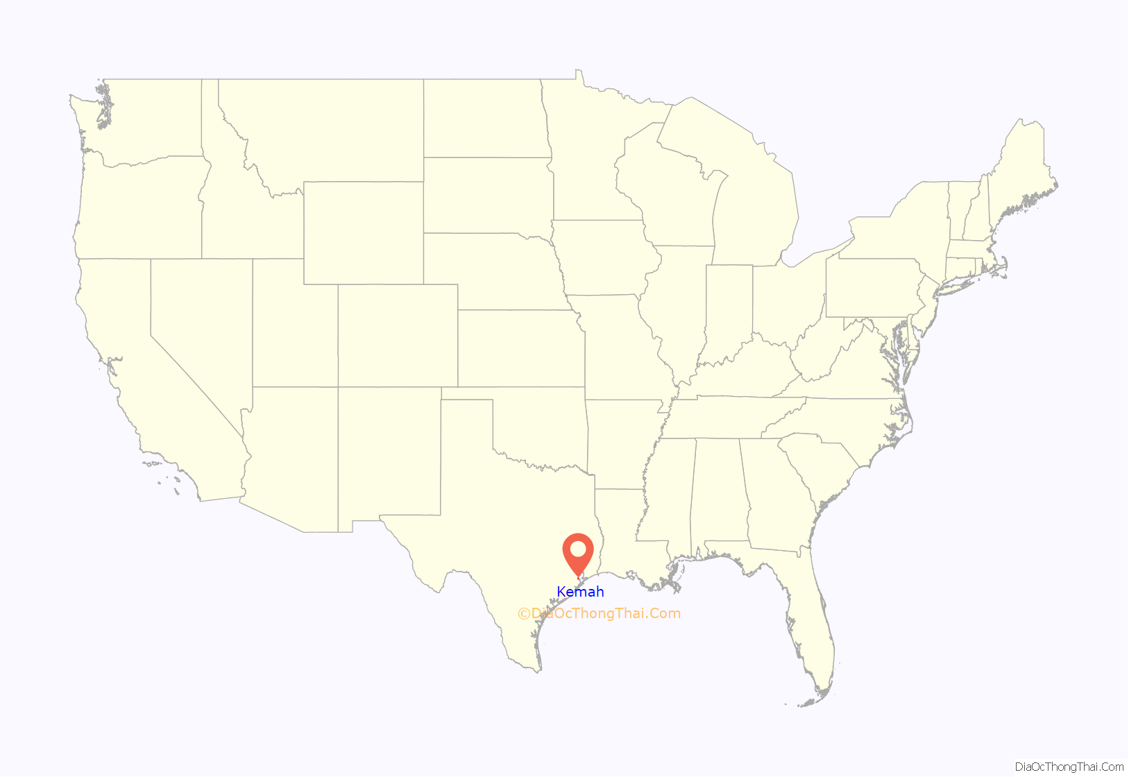
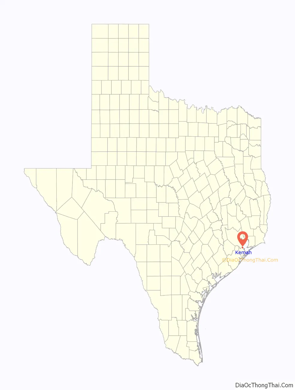
Kemah location map. Where is Kemah city?
History
The land, measuring approximately 177 acres (72 ha), was the basis for a town that would be called Kemah. This land was granted to one of the first colonists who was a farmer and stockraiser, Michael Gouldrich, on August 24, 1824. Gouldrich’s land was located near Clear Creek and Galveston Bay.
However, after Gouldrich disappeared, William Vince from Harris County acquired Gouldrich’s Clear Creek land. Afterwards John Flanders, an Alamo fighter who was not supposed to have taken any land, bought the property from William Vince and it was renamed “Flanders Grove” or “Flanders Labor”. When Flanders died at the age of 36, Allen Vince, of Vince’s Bayou, was appointed executor of Flanders’ estate in 1841. On May 28, 1844, there was a petition to sell the land to pay off debts. Soon after, the land was appraised for $2 an acre and sold to Jonathan D. Waters. He bought the Clear Creek land on July 2, 1844, for $354.
After October 1850, Waters sold 10 acres (4.0 ha) of the Clear Creek property to various people, but Henry Kipp eventually owned the land. During the 1890s, the Bradford and Kipp families moved to the area and portioned off the land into town lots in 1898, thus establishing the town known as “Evergreen”. It was located along the Texas and New Orleans Railroad, and the area was also called “Shell Siding” for the oyster shell middens lining the bay, in some places 20 to 30 feet (6.1 to 9.1 m) deep.
After the 1900 Galveston hurricane, when the majority of the towns around Galveston Bay were destroyed, the Kipp and Bradford families were forced to evacuate, but later moved back to Evergreen in 1901. They rebuilt and restored the town, making two-story homes with porches for themselves on 10th street. In order for there to be a post office in the town, the name had to be changed because there was already a town called Evergreen. The name “Kemah” was chosen with the Karankawa Indian word meaning “wind in my face”. In 1907, John H. Kipp Sr. established a post office in the newly named town of Kemah.
From the 1920s to the 1950s Kemah became a significant tourist destination resulting from investment by the Maceo crime syndicate which ran Galveston during this time. The syndicate created a lavish casino district along the boardwalk featuring venues such as the Chili Bowl and the Kemah Den. During the 1950s the state Attorney General and the Texas Rangers finally shut down the Galveston vice empire. Kemah’s casinos were closed and its tourism base declined drastically.
During the 1950s a major commercial shrimp fishing fleet was established in the town as the Clear Creek Channel was opened. Though Hurricane Carla severely damaged the city in 1961, the city rebuilt and the fishing business revived. During the 1970s, in part as a result of the establishment of the Johnson Space Center on Clear Lake, tourism began to re-emerge as pleasure boats began to fill the lake.
On October 22, 1966, the town of Kemah adopted Vernon’s Texas Civil Statutes and became a General Law City. In 1992, the city expanded to 2 square miles (5.2 km), or 1,280 acres (520 ha), and the population increased to 1,300 residents.
In the late 1990s, Kemah continued to expand and began to be known as a tourist and recreational hot spot. This occurred when Landry’s Restaurants opened the Kemah Boardwalk. The boardwalk now includes amusement rides for tourists and residents to enjoy. The boardwalk also has numerous restaurants, mainly owned and operated by Landry’s Restaurants, Inc. The boardwalk also gives guests the opportunity to stay in Kemah at the Boardwalk Inn, and to shop at the local retail shops and kiosks.
On the morning of September 13, 2008, a Category 2 hurricane named Ike made landfall in Galveston County. Although the hurricane caused more damage to Galveston, Kemah still felt the effects of the storm. Hurricane Ike caused power outages in Kemah, destruction of homes and business, and streets to be piled with trees and debris. However, most importantly, the storm surge affected the Kemah Boardwalk the most. Although it did not take Landry’s long to start to rebuild the tourist attraction, a waterline in the Landry’s Restaurant is a reminder of the devastating hurricane.
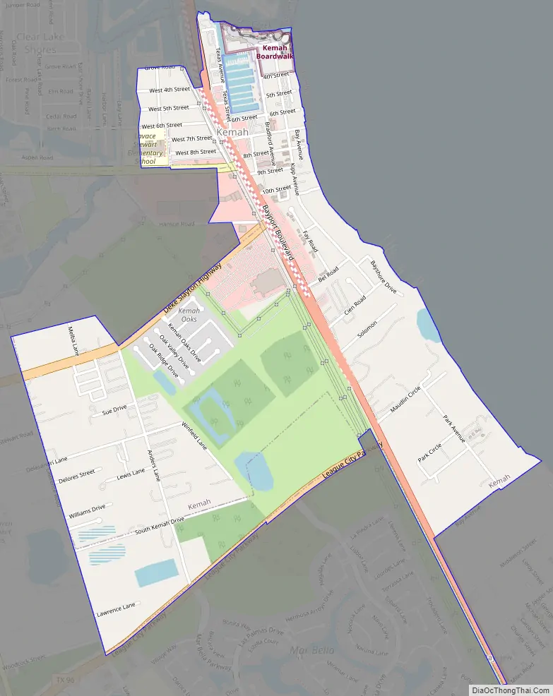
Kemah Road Map
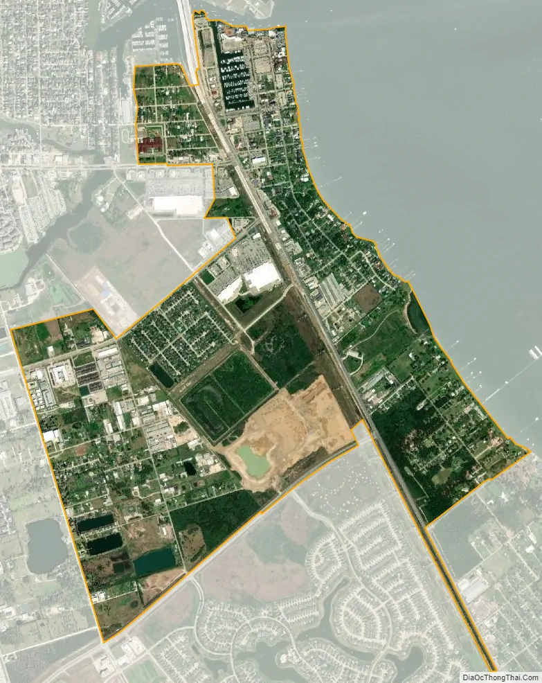
Kemah city Satellite Map
Geography
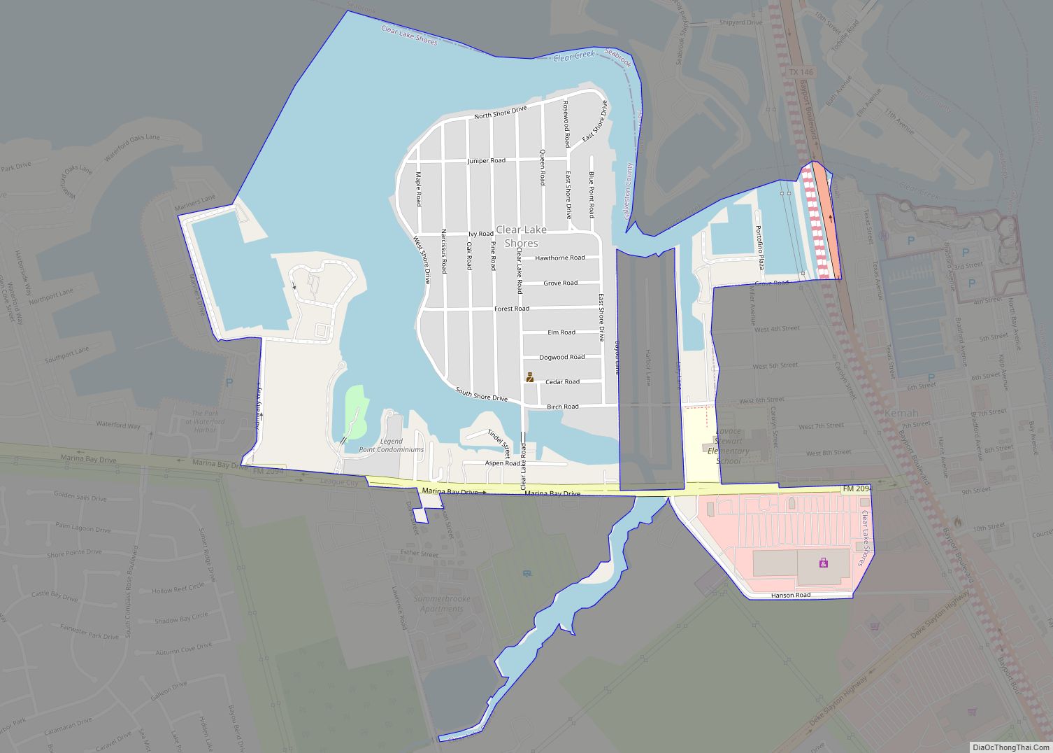
Kemah is located in the northeast corner of Galveston County at 29°32′33″N 95°1′13.08″W / 29.54250°N 95.0203000°W / 29.54250; -95.0203000 (29.5425, –95.0203) and is part of the Clear Lake Area. It is bordered to the west and south by League City, to the northwest by Clear Lake Shores, to the southeast by unincorporated Bacliff, and at its northern end by Seabrook across the Clear Creek Channel in Harris County. Texas State Highway 146 leads through the center of Kemah, leading north 15 miles (24 km) to Baytown and south 12 miles (19 km) to Texas City. Galveston is 25 miles (40 km) to the south, and Houston is 30 miles (48 km) to the northwest.
According to the United States Census Bureau, Kemah has a total area of 1.91 square miles (4.94 km), of which 1.84 square miles (4.76 km) are land and 0.069 square miles (0.18 km), or 3.55%, are water.
See also
Map of Texas State and its subdivision:- Anderson
- Andrews
- Angelina
- Aransas
- Archer
- Armstrong
- Atascosa
- Austin
- Bailey
- Bandera
- Bastrop
- Baylor
- Bee
- Bell
- Bexar
- Blanco
- Borden
- Bosque
- Bowie
- Brazoria
- Brazos
- Brewster
- Briscoe
- Brooks
- Brown
- Burleson
- Burnet
- Caldwell
- Calhoun
- Callahan
- Cameron
- Camp
- Carson
- Cass
- Castro
- Chambers
- Cherokee
- Childress
- Clay
- Cochran
- Coke
- Coleman
- Collin
- Collingsworth
- Colorado
- Comal
- Comanche
- Concho
- Cooke
- Coryell
- Cottle
- Crane
- Crockett
- Crosby
- Culberson
- Dallam
- Dallas
- Dawson
- Deaf Smith
- Delta
- Denton
- Dewitt
- Dickens
- Dimmit
- Donley
- Duval
- Eastland
- Ector
- Edwards
- El Paso
- Ellis
- Erath
- Falls
- Fannin
- Fayette
- Fisher
- Floyd
- Foard
- Fort Bend
- Franklin
- Freestone
- Frio
- Gaines
- Galveston
- Garza
- Gillespie
- Glasscock
- Goliad
- Gonzales
- Gray
- Grayson
- Gregg
- Grimes
- Guadalupe
- Hale
- Hall
- Hamilton
- Hansford
- Hardeman
- Hardin
- Harris
- Harrison
- Hartley
- Haskell
- Hays
- Hemphill
- Henderson
- Hidalgo
- Hill
- Hockley
- Hood
- Hopkins
- Houston
- Howard
- Hudspeth
- Hunt
- Hutchinson
- Irion
- Jack
- Jackson
- Jasper
- Jeff Davis
- Jefferson
- Jim Hogg
- Jim Wells
- Johnson
- Jones
- Karnes
- Kaufman
- Kendall
- Kenedy
- Kent
- Kerr
- Kimble
- King
- Kinney
- Kleberg
- Knox
- La Salle
- Lamar
- Lamb
- Lampasas
- Lavaca
- Lee
- Leon
- Liberty
- Limestone
- Lipscomb
- Live Oak
- Llano
- Loving
- Lubbock
- Lynn
- Madison
- Marion
- Martin
- Mason
- Matagorda
- Maverick
- McCulloch
- McLennan
- McMullen
- Medina
- Menard
- Midland
- Milam
- Mills
- Mitchell
- Montague
- Montgomery
- Moore
- Morris
- Motley
- Nacogdoches
- Navarro
- Newton
- Nolan
- Nueces
- Ochiltree
- Oldham
- Orange
- Palo Pinto
- Panola
- Parker
- Parmer
- Pecos
- Polk
- Potter
- Presidio
- Rains
- Randall
- Reagan
- Real
- Red River
- Reeves
- Refugio
- Roberts
- Robertson
- Rockwall
- Runnels
- Rusk
- Sabine
- San Augustine
- San Jacinto
- San Patricio
- San Saba
- Schleicher
- Scurry
- Shackelford
- Shelby
- Sherman
- Smith
- Somervell
- Starr
- Stephens
- Sterling
- Stonewall
- Sutton
- Swisher
- Tarrant
- Taylor
- Terrell
- Terry
- Throckmorton
- Titus
- Tom Green
- Travis
- Trinity
- Tyler
- Upshur
- Upton
- Uvalde
- Val Verde
- Van Zandt
- Victoria
- Walker
- Waller
- Ward
- Washington
- Webb
- Wharton
- Wheeler
- Wichita
- Wilbarger
- Willacy
- Williamson
- Wilson
- Winkler
- Wise
- Wood
- Yoakum
- Young
- Zapata
- Zavala
- Alabama
- Alaska
- Arizona
- Arkansas
- California
- Colorado
- Connecticut
- Delaware
- District of Columbia
- Florida
- Georgia
- Hawaii
- Idaho
- Illinois
- Indiana
- Iowa
- Kansas
- Kentucky
- Louisiana
- Maine
- Maryland
- Massachusetts
- Michigan
- Minnesota
- Mississippi
- Missouri
- Montana
- Nebraska
- Nevada
- New Hampshire
- New Jersey
- New Mexico
- New York
- North Carolina
- North Dakota
- Ohio
- Oklahoma
- Oregon
- Pennsylvania
- Rhode Island
- South Carolina
- South Dakota
- Tennessee
- Texas
- Utah
- Vermont
- Virginia
- Washington
- West Virginia
- Wisconsin
- Wyoming