Map of Henrieville town
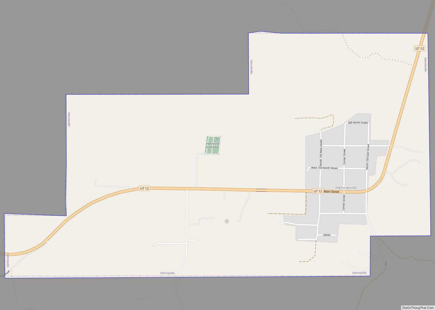
Henrieville is a town in Garfield County, Utah, United States, along Utah Scenic Byway 12. As of the 2010 census, the town population was 230, up from 159 at the 2000 census. The community was named after James Henrie, a Mormon leader. Henrieville town overview: Name: Henrieville town LSAD Code: 43 LSAD Description: town (suffix) ... Read more
Map of Henrieville town
Map of Henefer town
Henefer (/ˈhɛnəfɜːr/ HEN-ə-fər) is a town in Summit County, Utah, United States. It is part of the Salt Lake City, Utah Metropolitan Statistical Area. The population was 766 at the 2010 census. Henefer town overview: Name: Henefer town LSAD Code: 43 LSAD Description: town (suffix) State: Utah County: Summit County Founded: 1853 Incorporated: 1938 Elevation: ... Read more
Map of Henefer town
Map of Helper city
Helper is a city in Carbon County, Utah, United States, approximately 110 miles (180 km) southeast of Salt Lake City and 7 miles (11 km) northwest of the city of Price. The population was 2,201 at the 2010 census. The city is located along the Price River and U.S. Route 6/U.S. Route 191, a shortcut between Provo ... Read more
Map of Helper city
Map of Heber city, Utah
Heber city overview: Name: Heber city LSAD Code: 25 LSAD Description: city (suffix) State: Utah County: Wasatch County FIPS code: 4934200 Online Interactive Map Heber online map. Source: Basemap layers from Google Map, Open Street Map (OSM), Arcgisonline, Wmflabs. Boundary Data from Database of Global Administrative Areas. Heber location map. Where is Heber city? Heber ... Read more
Map of Heber city, Utah
Map of Holden town, Utah
Holden is a town in Millard County, Utah, United States. The population was 378 at the 2010 census. Holden town overview: Name: Holden town LSAD Code: 43 LSAD Description: town (suffix) State: Utah County: Millard County Incorporated: 1923 Elevation: 5,102 ft (1,555 m) Total Area: 0.54 sq mi (1.39 km²) Land Area: 0.54 sq mi (1.39 km²) Water Area: 0.00 sq mi (0.00 km²) Total Population: ... Read more
Map of Holden town, Utah
Map of Hinckley town, Utah
Hinckley is a town in Millard County, Utah, United States, in the middle of the Sevier Desert. Irrigation water from the Sevier River, passing nearby, has been used to turn Hinckley into a farming oasis. The mountains that are common in Utah are seen only in the distance, and beyond the reach of the river, ... Read more
Map of Hinckley town, Utah
Map of Huntington city, Utah
Huntington is a city in northwestern Emery County, Utah, United States. The population was 2,129 at the 2010 census. It is the largest town in Emery County. Huntington city overview: Name: Huntington city LSAD Code: 25 LSAD Description: city (suffix) State: Utah County: Emery County Founded: 1875 Elevation: 5,787 ft (1,764 m) Total Area: 2.26 sq mi (5.85 km²) Land ... Read more
Map of Huntington city, Utah
Map of Hoytsville CDP
Hoytsville is a census-designated place in western Summit County, Utah, United States. Hoytsville is named for early settler Samuel P. Hoyt. It is bordered by Coalville to the north, and by Wanship on the south. The population was 607 at the 2010 census. Interstate 80 passes through the area, as well as the Weber River. ... Read more
Map of Hoytsville CDP
Map of Holladay city
Holladay is a city in central Salt Lake County, Utah, United States. It is part of the Salt Lake City, Utah Metropolitan Statistical Area and abuts the Wasatch National Forest. The population was 31,965 at the 2020 census, a significant increase from 14,561 in 2000 when the first area incorporated from Salt Lake County. The ... Read more
Map of Holladay city
Map of Jensen CDP
Jensen is a census-designated place in eastern Uintah County, Utah, United States. The population was 412 at the 2010 census. It lies along the Green River and U.S. Route 40, southeast of the city of Vernal, the county seat of Uintah County, and about 17 miles west of the Colorado border. Although Jensen is unincorporated, ... Read more
Map of Jensen CDP
Map of Interlaken town, Utah
Interlaken is a town in northwestern Wasatch County, Utah, United States. The current mayor is Greg Harrigan Interlaken town overview: Name: Interlaken town LSAD Code: 43 LSAD Description: town (suffix) State: Utah County: Wasatch County Incorporated: May 20, 2015 Elevation: 5,919 ft (1,805 m) Total Area: 0.22 sq mi (0.58 km²) Land Area: 0.22 sq mi (0.58 km²) Water Area: 0.00 sq mi (0.00 km²) Total ... Read more
Map of Interlaken town, Utah
Map of Independence town, Utah
Independence is a town in Wasatch County, Utah, United States. Lying just east of U.S. Route 40 southeast of Heber City, Independence was incorporated in 2008 under a controversial, short-lived state law. The population was 164 at the 2010 census. Independence town overview: Name: Independence town LSAD Code: 43 LSAD Description: town (suffix) State: Utah ... Read more
Map of Independence town, Utah