Map of Gate City town
Gate City is a town in Scott County, Virginia, United States. The population was 2,034 at the 2010 census. It is the seat of Scott County. Gate City is part of the Kingsport–Bristol (TN)–Bristol (VA) Metropolitan Statistical Area, which is a component of the Johnson City–Kingsport–Bristol, TN-VA Combined Statistical Area – commonly known as the ... Read more
Map of Gate City town
Map of Gasburg CDP
Gasburg is a census-designated place (CDP) in Brunswick County, Virginia, United States. The population as of the 2010 Census was 481. Gasburg CDP overview: Name: Gasburg CDP LSAD Code: 57 LSAD Description: CDP (suffix) State: Virginia County: Brunswick County FIPS code: 5130480 Online Interactive Map Gasburg online map. Source: Basemap layers from Google Map, Open ... Read more
Map of Gasburg CDP
Map of Gargatha CDP
Gargatha is a census-designated place (CDP) in Accomack County, Virginia, United States. Per the 2020 census, the population was 415. Gargatha CDP overview: Name: Gargatha CDP LSAD Code: 57 LSAD Description: CDP (suffix) State: Virginia County: Accomack County Elevation: 5 m (16 ft) Total Area: 415 FIPS code: 5130384 GNISfeature ID: 2584849 Online Interactive Map Gargatha online ... Read more
Map of Gargatha CDP
Map of Gainesville CDP, Virginia
Gainesville is a census-designated place (CDP) in western Prince William County, Virginia, United States. The population was 17,287 in the 2020 census. Gainesville CDP overview: Name: Gainesville CDP LSAD Code: 57 LSAD Description: CDP (suffix) State: Virginia County: Prince William County Elevation: 354 ft (108 m) Total Area: 10.3 sq mi (26.6 km²) Land Area: 9.7 sq mi (25.2 km²) Water Area: 0.6 sq mi ... Read more
Map of Gainesville CDP, Virginia
Map of Front Royal town
Front Royal is the only incorporated town in Warren County, Virginia, United States. The population was 15,011 at the 2020 census. It is the county seat of Warren County. Front Royal town overview: Name: Front Royal town LSAD Code: 43 LSAD Description: town (suffix) State: Virginia County: Warren County Founded: 1788 Elevation: 568 ft (173 m) Total ... Read more
Map of Front Royal town
Map of Fries town
Fries (pronounced “freeze”) is an incorporated town located on the New River in Grayson County, Virginia, 24 kilometers (15.5 mi) north-east of the county seat in Independence — in Virginia’s Blue Ridge Highlands and on Virginia’s musical heritage trail, The Crooked Road. Named after prominent cotton mill owner, Francis Henry Fries, the town is noted as ... Read more
Map of Fries town
Map of Free Union CDP
Free Union CDP overview: Name: Free Union CDP LSAD Code: 57 LSAD Description: CDP (suffix) State: Virginia County: Albemarle County FIPS code: 5129840 Online Interactive Map Free Union online map. Source: Basemap layers from Google Map, Open Street Map (OSM), Arcgisonline, Wmflabs. Boundary Data from Database of Global Administrative Areas. Free Union location map. Where ... Read more
Map of Free Union CDP
Map of Franklin Farm CDP
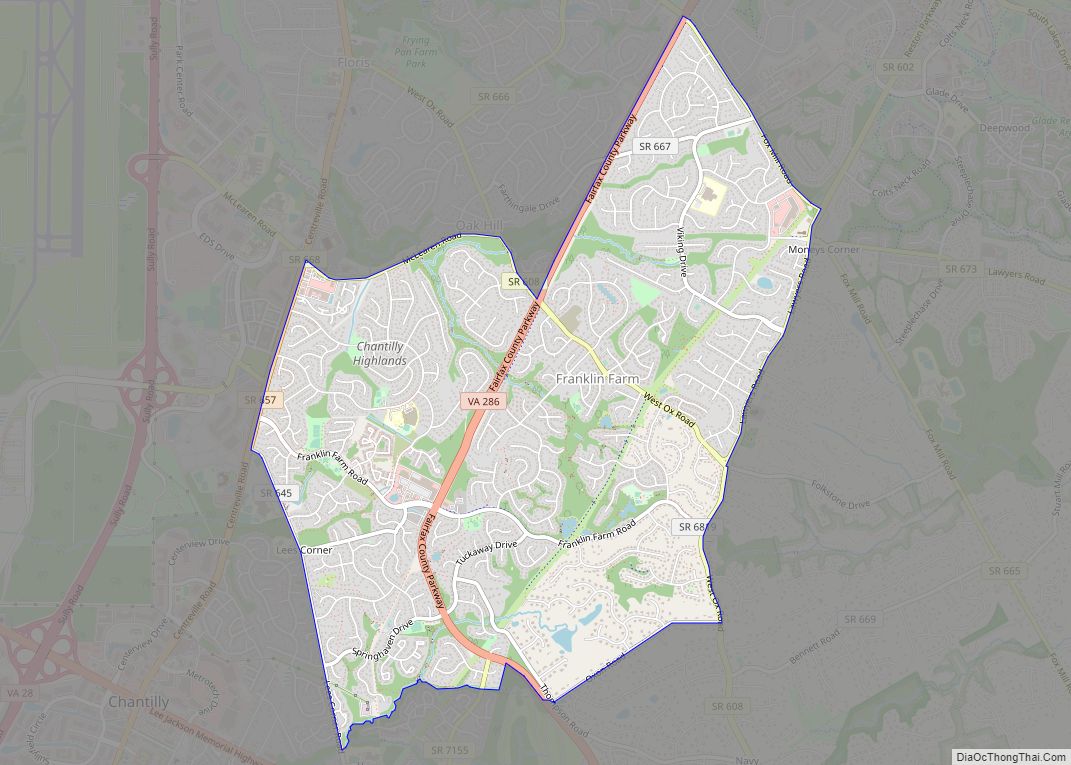
Franklin Farm refers to both a census-designated place (CDP) and a planned community located within the Oak Hill section of Fairfax County, Virginia, United States. It is a suburb of Washington, D.C., located about 20 miles west of the White House. The Franklin Farm CDP, which was named for the older planned community contained within, ... Read more
Map of Franklin Farm CDP
Map of Gloucester Courthouse CDP
Gloucester Courthouse is a census-designated place (CDP) in and the county seat of Gloucester County, Virginia, United States. The population was 2,951 at the 2010 census. Gloucester Courthouse CDP overview: Name: Gloucester Courthouse CDP LSAD Code: 57 LSAD Description: CDP (suffix) State: Virginia County: Gloucester County Elevation: 33 ft (10 m) Total Area: 7.2 sq mi (18.6 km²) Land Area: ... Read more
Map of Gloucester Courthouse CDP
Map of Glenvar CDP
Glenvar CDP overview: Name: Glenvar CDP LSAD Code: 57 LSAD Description: CDP (suffix) State: Virginia County: Roanoke County FIPS code: 5131488 Online Interactive Map Glenvar online map. Source: Basemap layers from Google Map, Open Street Map (OSM), Arcgisonline, Wmflabs. Boundary Data from Database of Global Administrative Areas. Glenvar location map. Where is Glenvar CDP? Glenvar ... Read more
Map of Glenvar CDP
Map of Glen Lyn town
Glen Lyn is a town in Giles County, Virginia, United States, at the confluence of the East and New rivers. The population was 115 at the 2010 census, down from 151 at the 2000 census. It is part of the Blacksburg–Christiansburg Metropolitan Statistical Area. Glen Lyn town overview: Name: Glen Lyn town LSAD Code: 43 ... Read more
Map of Glen Lyn town
Map of Glasgow town, Virginia
Glasgow is a town in Rockbridge County, Virginia, United States, at the confluence of the James and Maury Rivers. The population was 1,133 at the 2010 census. Glasgow has had issues with flooding, notably during Hurricane Camille in 1969. As a result of flooding concerns, the Balcony Falls Dam (just east of the confluence of ... Read more
Map of Glasgow town, Virginia