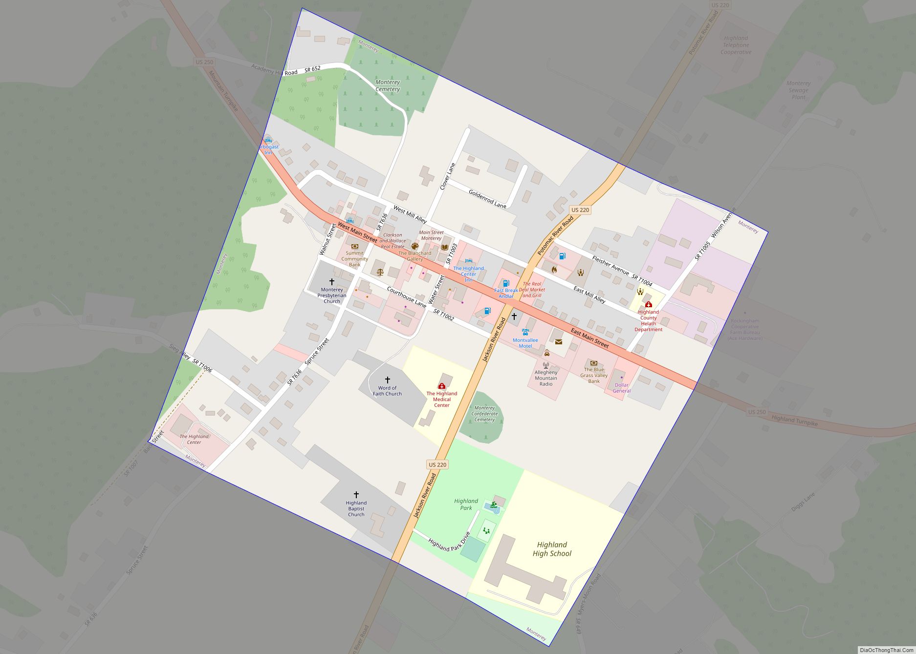
Map of Irvington town, Virginia

Map of Irvington town, Virginia

Irvington is a town on the Rappahannock River in Lancaster County, Virginia, United States. The population was 432 at the 2010 census. Located on a peninsula known as the Northern Neck, it has been designated a historic district. Irvington town overview: Name: Irvington town LSAD Code: 43 LSAD Description: town (suffix) State: Virginia County: Lancaster … Read more

Map of Iron Gate town

Map of Iron Gate town

Iron Gate is a town in eastern Alleghany County, Virginia, United States. The population was 324 at the 2020 census. The town is located along U.S. Route 220, near Clifton Forge. Iron Gate town overview: Name: Iron Gate town LSAD Code: 43 LSAD Description: town (suffix) State: Virginia County: Alleghany County Elevation: 1,037 ft (316 m) Total … Read more

Map of Kenbridge town

Map of Kenbridge town

Kenbridge is a town in Lunenburg County, Virginia, United States. The population was 1,257 at the 2010 census. It is in a tobacco farming area. The area is home to noted folk artist Eldridge Bagley. Kenbridge town overview: Name: Kenbridge town LSAD Code: 43 LSAD Description: town (suffix) State: Virginia County: Lunenburg County Founded: 1908 … Read more

Map of Keller town, Virginia

Map of Keller town, Virginia

Keller is a town in Accomack County, Virginia, United States. The population was 178 at the 2010 census. Keller town overview: Name: Keller town LSAD Code: 43 LSAD Description: town (suffix) State: Virginia County: Accomack County Elevation: 39 ft (12 m) Total Area: 0.34 sq mi (0.89 km²) Land Area: 0.34 sq mi (0.89 km²) Water Area: 0.00 sq mi (0.00 km²) Total Population: 178 Population … Read more

Map of Jonesville town, Virginia

Map of Jonesville town, Virginia

Jonesville is a town in and the county seat of Lee County, Virginia, United States. The population was 1,034 at the 2010 census. Jonesville town overview: Name: Jonesville town LSAD Code: 43 LSAD Description: town (suffix) State: Virginia County: Lee County Elevation: 1,503 ft (458 m) Total Area: 1.11 sq mi (2.88 km²) Land Area: 1.11 sq mi (2.88 km²) Water Area: 0.00 sq mi … Read more

Map of Jolivue CDP

Map of Jolivue CDP

Jolivue CDP overview: Name: Jolivue CDP LSAD Code: 57 LSAD Description: CDP (suffix) State: Virginia County: Augusta County FIPS code: 5141144 Online Interactive Map Jolivue online map. Source: Basemap layers from Google Map, Open Street Map (OSM), Arcgisonline, Wmflabs. Boundary Data from Database of Global Administrative Areas. Jolivue location map. Where is Jolivue CDP? Jolivue … Read more

Map of Jarratt town

Map of Jarratt town

Jarratt is a town in Greensville and Sussex counties in the U.S. state of Virginia. The population was 652 at the 2020 census. In 1848, Jarratt was a stop on the Petersburg Railroad. Jaratt was incorporated in 1938. Jarratt town overview: Name: Jarratt town LSAD Code: 43 LSAD Description: town (suffix) State: Virginia County: Greensville … Read more

Map of Ivy CDP

Map of Ivy CDP

Ivy is a census-designated place (CDP) in Albemarle County, Virginia, United States. The population as of the 2010 Census was 905. It is a small unincorporated community located on U.S. Route 250, just west of Charlottesville. D. S. Tavern, Home Tract, Spring Hill, Woodstock Hall Tavern and Blue Ridge Swim Club are listed on the … Read more

Map of Ivor town

Map of Ivor town

Ivor is an incorporated town in Southampton County, Virginia, United States. It is twenty-three miles northwest of Suffolk. The population was 320 at the 2000 census. Ivor town overview: Name: Ivor town LSAD Code: 43 LSAD Description: town (suffix) State: Virginia County: Southampton County Elevation: 89 ft (27 m) Total Area: 1.09 sq mi (2.83 km²) Land Area: 1.09 sq mi (2.82 km²) … Read more

Map of Ivanhoe CDP, Virginia

Map of Ivanhoe CDP, Virginia

Ivanhoe is a census-designated place (CDP) in southern Wythe County, Virginia, United States, that straddles the border of Wythe and Carroll counties. The population as of the 2010 Census was 551. Ivanhoe is situated in the Appalachian Mountains along New River, and New River Trail State Park passes through Ivanhoe. Ivanhoe CDP overview: Name: Ivanhoe … Read more

Map of Kings Park CDP, Virginia

Map of Kings Park CDP, Virginia

Kings Park is a census-designated place (CDP) in the eastern United States in Fairfax County, Virginia, southwest of Washington D.C. The population as of the 2010 census was 4,333. A suburban community begun 63 years ago in early 1960, Kings Park is located a few miles west of the Capital Beltway and Annandale, near the … Read more

Map of Kings Park West CDP

Map of Kings Park West CDP

Kings Park West is a census-designated place in the eastern USA, in Fairfax County, Virginia, southwest of Washington, D.C. The population as of the 2010 census was 13,390. Kings Park West CDP overview: Name: Kings Park West CDP LSAD Code: 57 LSAD Description: CDP (suffix) State: Virginia County: Fairfax County Elevation: 400 ft (100 m) Total Area: … Read more