Montross is a town in Westmoreland County, Virginia, United States. The population was 553 at the 2020 census. It is the county seat of Westmoreland County. Located in the historic Northern Neck of Virginia, Montross is near the George Washington Birthplace National Monument and the Stratford Hall Plantation (the birthplace of Robert E. Lee and Founding Fathers and signers of the Declaration of Independence, Richard Henry Lee and Francis Lightfoot Lee). The town’s slogan is return to the village.
| Name: | Montross town |
|---|---|
| LSAD Code: | 43 |
| LSAD Description: | town (suffix) |
| State: | Virginia |
| County: | Westmoreland County |
| Elevation: | 164 ft (50 m) |
| Total Area: | 1.03 sq mi (2.67 km²) |
| Land Area: | 1.03 sq mi (2.67 km²) |
| Water Area: | 0.00 sq mi (0.00 km²) |
| Total Population: | 553 |
| Population Density: | 536.6/sq mi (146.11/km²) |
| ZIP code: | 22520 |
| Area code: | 804 |
| FIPS code: | 5152952 |
| GNISfeature ID: | 1498518 |
| Website: | https://www.townofmontross.org |
Online Interactive Map
Click on ![]() to view map in "full screen" mode.
to view map in "full screen" mode.
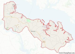
Montross location map. Where is Montross town?


History
The Old Westmoreland Court House in Montross was the site of notable events in 1774–1775 connected with the Revolutionary War. According to an historic marker at the courthouse, a resolution was introduced by Richard Henry Lee and adopted at a meeting there on June 22, 1774, providing aid to Boston, Massachusetts, following a blockade of that beleaguered port city by Great Britain. The seizure in 1775 of the Virginia Colony’s gunpowder supply in Williamsburg on orders of the Royal Governor, in what became known as the Gunpowder Incident, prompted the Westmoreland Committee of Safety to convene at the Court House on May 23, 1775. The committee passed a resolution denouncing the governor, Lord Dunmore, for his actions.
Washington and Lee High School is located in the town.
Emmy Award-winning video engineer Walter Balderson, who attended Washington and Lee High School, is from Montross. Current Brooklyn Nets forward Justin Anderson was born in Montross, and played collegiately at the University of Virginia.
The Armstead T. Johnson High School, Westmoreland State Park Historic District, and Panorama are listed on the National Register of Historic Places.
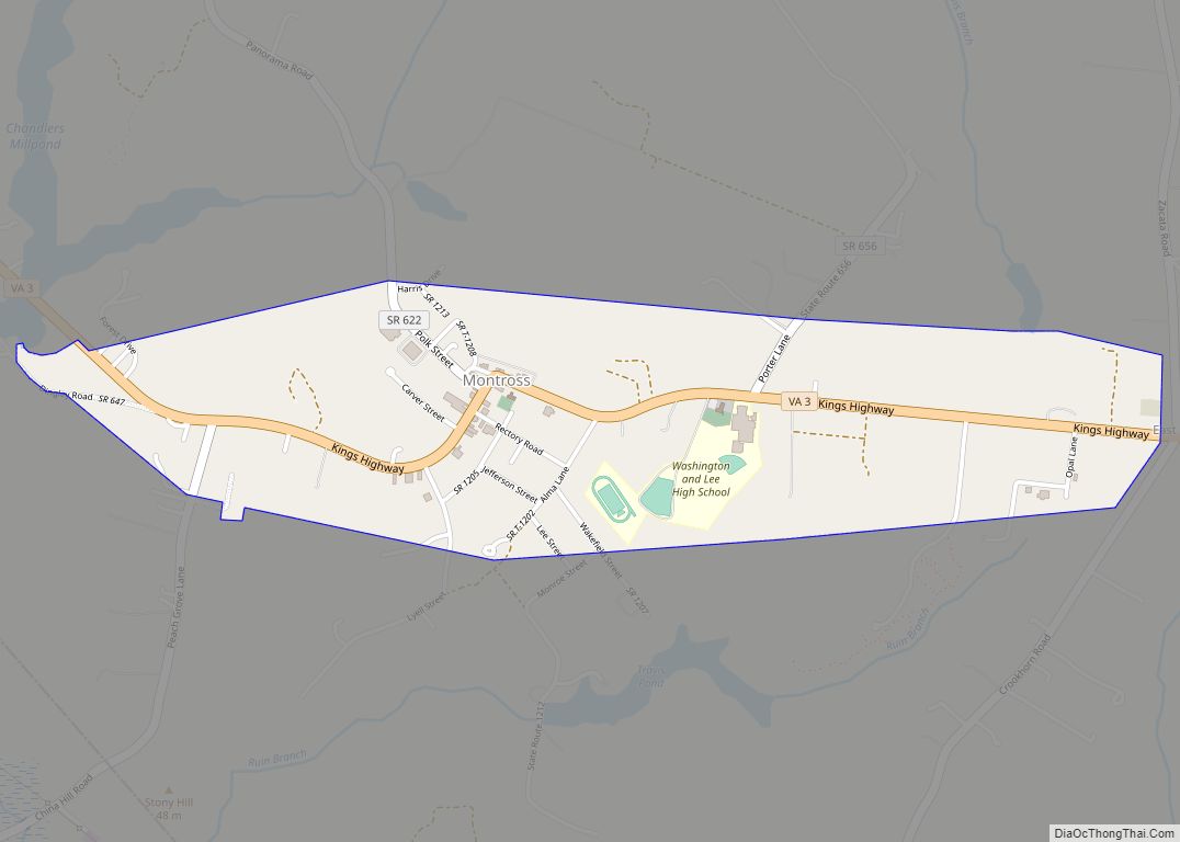
Montross Road Map
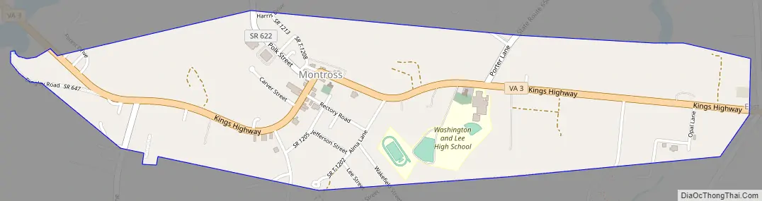
Montross city Satellite Map

Geography
Montross is located at 38°5′38″N 76°49′34″W / 38.09389°N 76.82611°W / 38.09389; -76.82611 (38.093965, −76.826041). According to the U.S. Census Bureau, the town has a total area of 1.0 square miles (2.6 km), all of it land.
See also
Map of Virginia State and its subdivision:- Accomack
- Albemarle
- Alexandria
- Alleghany
- Amelia
- Amherst
- Appomattox
- Arlington
- Augusta
- Bath
- Bedford
- Bedford City
- Bland
- Botetourt
- Bristol
- Brunswick
- Buchanan
- Buckingham
- Buena Vista
- Campbell
- Caroline
- Carroll
- Charles City
- Charlotte
- Charlottesville
- Chesapeake
- Chesterfield
- Clarke
- Clifton Forge City
- Colonial Heights
- Covington
- Craig
- Culpeper
- Cumberland
- Danville
- Dickenson
- Dinwiddie
- Emporia
- Essex
- Fairfax
- Fairfax City
- Falls Church
- Fauquier
- Floyd
- Fluvanna
- Franklin
- Frederick
- Fredericksburg
- Galax
- Giles
- Gloucester
- Goochland
- Grayson
- Greene
- Greensville
- Halifax
- Hampton
- Hanover
- Harrisonburg
- Henrico
- Henry
- Highland
- Hopewell
- Isle of Wight
- James City
- King and Queen
- King George
- King William
- Lancaster
- Lee
- Lexington
- Loudoun
- Louisa
- Lunenburg
- Lynchburg
- Madison
- Manassas
- Manassas Park
- Martinsville
- Mathews
- Mecklenburg
- Middlesex
- Montgomery
- Nelson
- New Kent
- Newport News
- Norfolk
- Northampton
- Northumberland
- Norton
- Nottoway
- Orange
- Page
- Patrick
- Petersburg
- Pittsylvania
- Poquoson
- Portsmouth
- Powhatan
- Prince Edward
- Prince George
- Prince William
- Pulaski
- Radford
- Rappahannock
- Richmond
- Roanoke
- Roanoke City
- Rockbridge
- Rockingham
- Russell
- Salem
- Scott
- Shenandoah
- Smyth
- Southampton
- Spotsylvania
- Stafford
- Staunton
- Suffolk
- Surry
- Sussex
- Tazewell
- Virginia Beach
- Warren
- Washington
- Waynesboro
- Westmoreland
- Williamsburg
- Winchester
- Wise
- Wythe
- York
- Alabama
- Alaska
- Arizona
- Arkansas
- California
- Colorado
- Connecticut
- Delaware
- District of Columbia
- Florida
- Georgia
- Hawaii
- Idaho
- Illinois
- Indiana
- Iowa
- Kansas
- Kentucky
- Louisiana
- Maine
- Maryland
- Massachusetts
- Michigan
- Minnesota
- Mississippi
- Missouri
- Montana
- Nebraska
- Nevada
- New Hampshire
- New Jersey
- New Mexico
- New York
- North Carolina
- North Dakota
- Ohio
- Oklahoma
- Oregon
- Pennsylvania
- Rhode Island
- South Carolina
- South Dakota
- Tennessee
- Texas
- Utah
- Vermont
- Virginia
- Washington
- West Virginia
- Wisconsin
- Wyoming