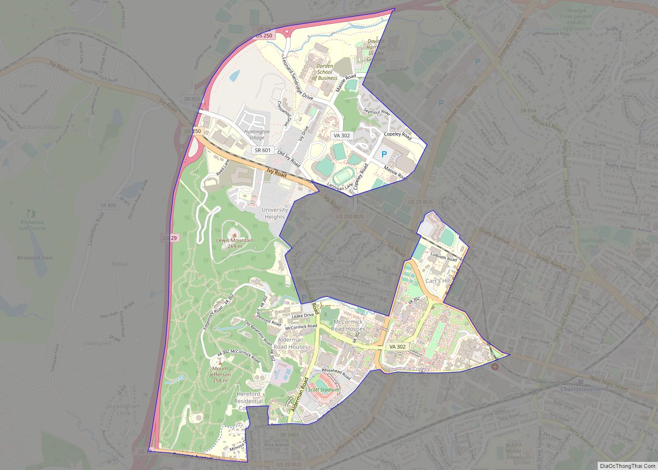
Map of Prices Fork CDP

Map of Prices Fork CDP

Prices Fork is a small traditionally agricultural census-designated place (CDP), in Montgomery County, Virginia, United States. The population as of the 2010 Census was 1,066. It is located about three miles west of Blacksburg and the campus of Virginia Polytechnic Institute and State University (Virginia Tech). The community is a part of the Blacksburg–Christiansburg metropolitan … Read more

Map of Powhatan CDP, Virginia

Map of Powhatan CDP, Virginia

Powhatan CDP overview: Name: Powhatan CDP LSAD Code: 57 LSAD Description: CDP (suffix) State: Virginia FIPS code: 5164384 Online Interactive Map Powhatan online map. Source: Basemap layers from Google Map, Open Street Map (OSM), Arcgisonline, Wmflabs. Boundary Data from Database of Global Administrative Areas. Powhatan location map. Where is Powhatan CDP? Powhatan Road Map Powhatan … Read more

Map of Pound town

Map of Pound town, Virginia

Pound is a town in Wise County, Virginia, United States. The population was recorded as 1,037 in the 2010 United States Census. Pound town overview: Name: Pound town LSAD Code: 43 LSAD Description: town (suffix) State: Virginia County: Wise County Elevation: 1,565 ft (477 m) Total Area: 2.61 sq mi (6.75 km²) Land Area: 2.60 sq mi (6.75 km²) Water Area: 0.00 sq mi (0.01 km²) … Read more

Map of Potomac Mills CDP

Map of Potomac Mills CDP

Potomac Mills is a census-designated place in Prince William County, Virginia. The population as of the 2010 Census was 5,614. It consists of the Potomac Mills mall and surrounding residential and commercial area, adjoining Dale City and Lake Ridge. Potomac Mills CDP overview: Name: Potomac Mills CDP LSAD Code: 57 LSAD Description: CDP (suffix) State: … Read more

Map of Rich Creek town

Map of Rich Creek town

Rich Creek is a town in Giles County, Virginia, United States. The population was 774 as per the 2010 census, up from 665 as per the 2000 census. It is part of the Blacksburg–Christiansburg Metropolitan Statistical Area. Rich Creek town overview: Name: Rich Creek town LSAD Code: 43 LSAD Description: town (suffix) State: Virginia County: … Read more

Map of Reston CDP

Map of Reston CDP

Reston is a census-designated place in Fairfax County, Virginia, and a principal city of the Washington metropolitan area. As of the 2020 U.S. Census, Reston’s population was 63,226. Founded in 1964, Reston was influenced by the Garden City movement that emphasized planned, self-contained communities that intermingled green space, residential neighborhoods, and commercial development. The intent … Read more

Map of Remington town, Virginia

Map of Remington town, Virginia

Remington is a small incorporated town in Fauquier County, Virginia, United States. The population was 598 at the 2010 census. It is near the highways, U.S. Route 15, U.S. Route 17, U.S. Route 29, and Virginia State Route 28. Remington is less than a mile northeast of the Culpeper County line. Remington town overview: Name: … Read more

Map of Ravensworth CDP

Map of Ravensworth CDP

Ravensworth is a census-designated place in Fairfax County, Virginia, United States. Its name reflects Ravensworth plantation, farmed since the 18th century and manor house which burned under mysterious circumstances on August 1, 1926. The Ravensworth Farm subdivision was developed in the early 1960s. The 2010 census lists the area’s population as 2,466. It is part … Read more

Map of Raven CDP

Map of Raven CDP

Raven is a census-designated place (CDP) in Russell and Tazewell counties in the U.S. state of Virginia. The population was 2,270 at the 2010 census. Raven CDP overview: Name: Raven CDP LSAD Code: 57 LSAD Description: CDP (suffix) State: Virginia County: Russell County, Tazewell County Elevation: 1,913 ft (583 m) Total Area: 6.8 sq mi (17.7 km²) Land Area: 6.8 sq mi … Read more

Map of Quinby CDP, Virginia

Map of Quinby CDP, Virginia

Quinby is a census-designated place (CDP) in Accomack County, Virginia, United States. It was first listed as a CDP in 2010. Per the 2020 census, the population was 285. Quinby CDP overview: Name: Quinby CDP LSAD Code: 57 LSAD Description: CDP (suffix) State: Virginia County: Accomack County Elevation: 7 ft (2 m) Total Area: 285 FIPS code: … Read more

Map of Rivanna CDP

Map of Rivanna CDP

Rivanna is a census-designated place (CDP) in Albemarle County, Virginia, just east of Shadwell. The population as of the 2010 Census was 1,860. It consists mainly of the Glenmore gated community. Rivanna CDP overview: Name: Rivanna CDP LSAD Code: 57 LSAD Description: CDP (suffix) State: Virginia County: Albemarle County Total Area: 2,174 ZIP code: 22947 … Read more

Map of Riner CDP

Map of Riner CDP

Riner is a census-designated place in Montgomery County, Virginia, United States. The population as of the 2020 Census was 1,196. The Howard-Bell-Feather House and Riner Historic District are listed on the National Register of Historic Places. Auburn Elementary School, Auburn Middle School, and Auburn High School are all located in Riner. Camp Carysbrook is the … Read more