Victoria is an incorporated town in Lunenburg County, Virginia, United States. The population was 1,725 at the 2010 census, which was down from the 1,821 reported in 2000.
| Name: | Victoria town |
|---|---|
| LSAD Code: | 43 |
| LSAD Description: | town (suffix) |
| State: | Virginia |
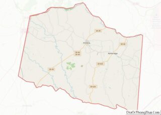
| County: | Lunenburg County |
| Elevation: | 587 ft (179 m) |
| Total Area: | 2.85 sq mi (7.38 km²) |
| Land Area: | 2.82 sq mi (7.29 km²) |
| Water Area: | 0.03 sq mi (0.09 km²) |
| Total Population: | 1,725 |
| Population Density: | 577.41/sq mi (222.92/km²) |
| ZIP code: | 23974 |
| Area code: | 434 |
| FIPS code: | 5181024 |
| GNISfeature ID: | 1496356 |
| Website: | www.victoriava.net |
Online Interactive Map
Click on ![]() to view map in "full screen" mode.
to view map in "full screen" mode.
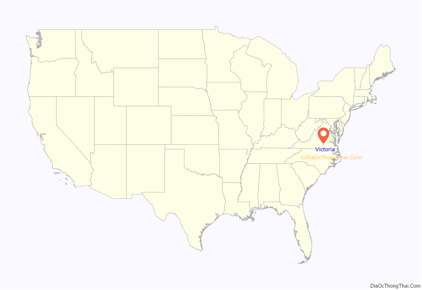
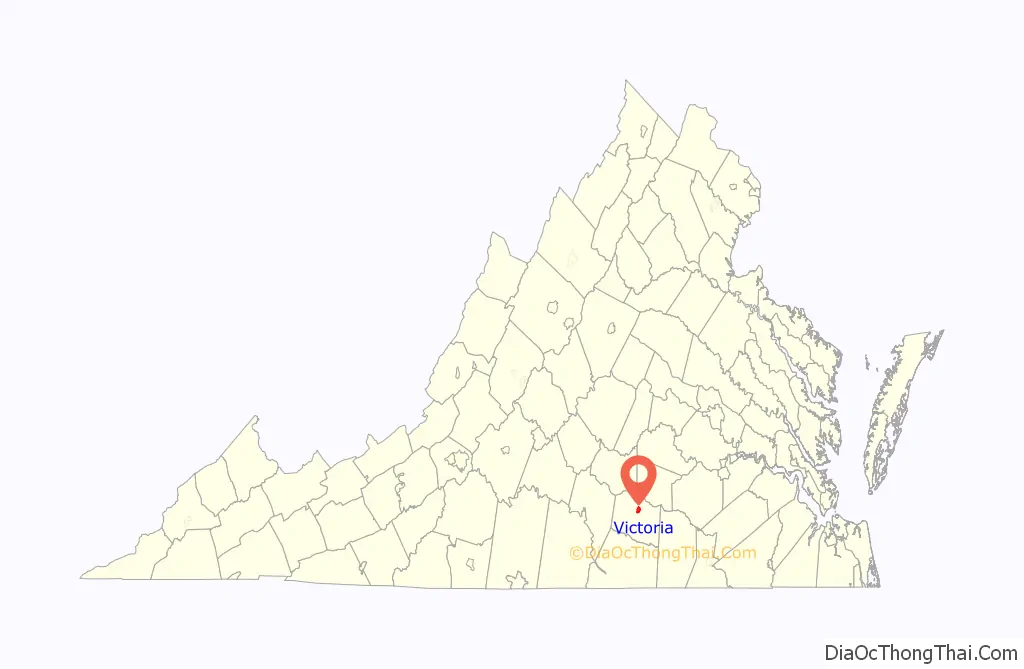
Victoria location map. Where is Victoria town?
History
Lunenburg County in the Southside region was established on May 1, 1746, in Great Britain’s Virginia Colony from Brunswick County. The county is named for the former Duchy of Brunswick-Lunenburg in Germany, because one of the titles also carried by Britain’s Hanoverian kings was Duke of Brunswick-Lunenburg.
After statehood, Virginia grew as part of the original 13 United States. Beginning in 1816, the Virginia Board of Public Works began providing engineering and financial assistance to internal improvements around the state in transportation which continued during most of the 19th century. However, Lunenburg County had been largely passed by as canals, turnpikes, and railroads were built across much of Virginia. At the beginning of the 20th century, the area which was to become Victoria was mostly farmland (primarily cultivating tobacco) and woodlands.
Born as a railroad town
Victoria was founded in 1906 as a planned community on what had been largely undeveloped land during the construction of the Tidewater Railway. This was a new east–west railroad chartered in 1904 with its right of way quietly secured in 1904 and 1905, so as to not alert the competition regarding plans to transport coal originated by its sister Deepwater Railway operating in southern West Virginia. The Tidewater Railway was chartered to cross Virginia from the West Virginia border near Glen Lyn, Virginia in Giles County by way of Roanoke and Suffolk to port at Sewell’s Point on Hampton Roads near Norfolk, Virginia. Both railroads were planned and built by the team of mining manager and civil engineer William Nelson Page and industrialist and financier Henry Huttleston Rogers, and added a third Hampton Roads coal exporting railhead to the existing Chesapeake and Ohio Railway (with coal piers at Newport News) and the Norfolk and Western Railway’s similar facilities at Norfolk’s Lambert’s Point.
Queen Victoria of the United Kingdom was a favorite of Henry Rogers, and the new town was named in her honor. Victoria was the midpoint of the VGN’s Norfolk Division, which extended from Sewell’s Point to Roanoke. Designated to be a “division point” on the railroad (specifically a location for crew changes and servicing of the steam locomotives), Victoria became the location of a large equipment maintenance operation with roundhouse, turntable, coaling and water facilities for servicing steam locomotives, and a large yard.
According to author H. Reid in his 1961 book The Virginian Railway, investors recalled the rapid growth of Roanoke between 1882 and 1884, which had been nicknamed the “Magic City” when the Norfolk and Western (N&W) had established major facilities at the former bucolic location which had been earlier known as Big Lick. Comparisons were made when speculating about Victoria’s future potential. They could also look to nearby Crewe on the N&W (about 20 miles away from Victoria) to see what a substantial volume of activity and employment a division point on a steam railroad could bring. Predictably, land sales at Victoria were brisk, and buildings (and jobs) soon followed.
In 1907, as they began nearing completion, the Tidewater and Deepwater Railways were combined to form the Virginian Railway (VGN). In March, the Tidewater Railway was formally rechartered by the Virginia State Corporation Commission as “The Virginian Railway Company” and William Nelson Page was elected president on April 15, 1907, at the first new board meeting in Norfolk. On April 22, the Deepwater Railway was acquired, formalizing the marriage of the two roads. Passenger service from Victoria to Norfolk began on June 17, 1907. The trip from Victoria took 12 hours, and operated once daily in each direction except Sundays, according to the first schedules published in the Norfolk Virginian-Pilot newspaper.
That first summer and fall, in conjunction with the Norfolk and Southern Railway (a regional predecessor of the 21st century Norfolk Southern System), service was offered to the Jamestown Exposition being held in Norfolk County that same summer. At the Exposition, VGN president Page served as Chief of International Jury of Awards, Mines and Metallurgy. United States President Theodore Roosevelt, attending the Jamestown Exposition, was one of the VGN’s earliest passengers, according to author Reid.
Adjacent to the Jamestown Exposition site on Hampton Roads at Sewell’s Point, a new coal pier was being built. Completion of the entire railroad took 2 additional years. The low gradient VGN was considered an engineering marvel of the time when it was completed in 1909. Soon, coal and other commodities began rolling through Victoria. The new Norfolk Division offices of the railroad were on located on a second floor which was added to the original Victoria passenger station a short time later.
The Virginia General Assembly granted a charter and incorporated the Town of Victoria on March 11, 1916.
Bechelbronn and Victoria High School are listed on the National Register of Historic Places.
End of steam, mergers, abandonment
Victoria’s importance as a rail point declined sharply in the 1950s when the change to diesel-electric locomotives greatly reduced the labor and facilities needed. The last Virginian passenger train served Victoria in January, 1956. VGN steam operations ended completely in June, 1957. Then, on December 1, 1959, the Virginian Railway merged with the larger Norfolk and Western Railway. Under combined operations, the through coal traffic was shifted from Victoria to the bigger road’s main line through Crewe, Virginia, within commuting distance for N&W’s Victoria-based employees. Local customers on the former VGN line through Victoria and nearby Kenbridge were few, and the portion of the line through Victoria and Kenbridge was eventually abandoned in the 1980s. All tracks and virtually all structures were removed, and a portion of the land donated to the community by N&W.
Much like many other communities all across the United States, the end of steam railroading and the era of mergers and consolidation in the second half of the 20th century reduced rail-oriented employment opportunities and had a generally negative impact upon Victoria and the surrounding area. However, the community and Lunenburg County proved resilient, and by the late 1990s, transportation employment represented only a minimal portion of the area’s economy.
One of the biggest industries in Victoria is the prison industry. Located two miles from the center of town, the Lunenburg Correctional Center provides employment for many people living in and around Victoria.
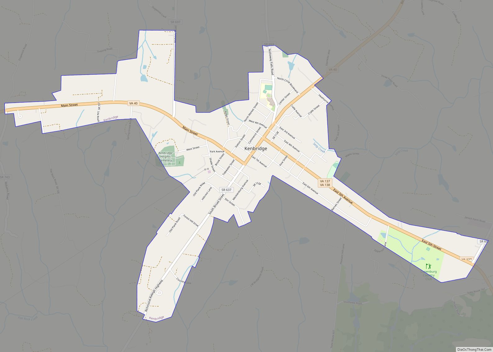
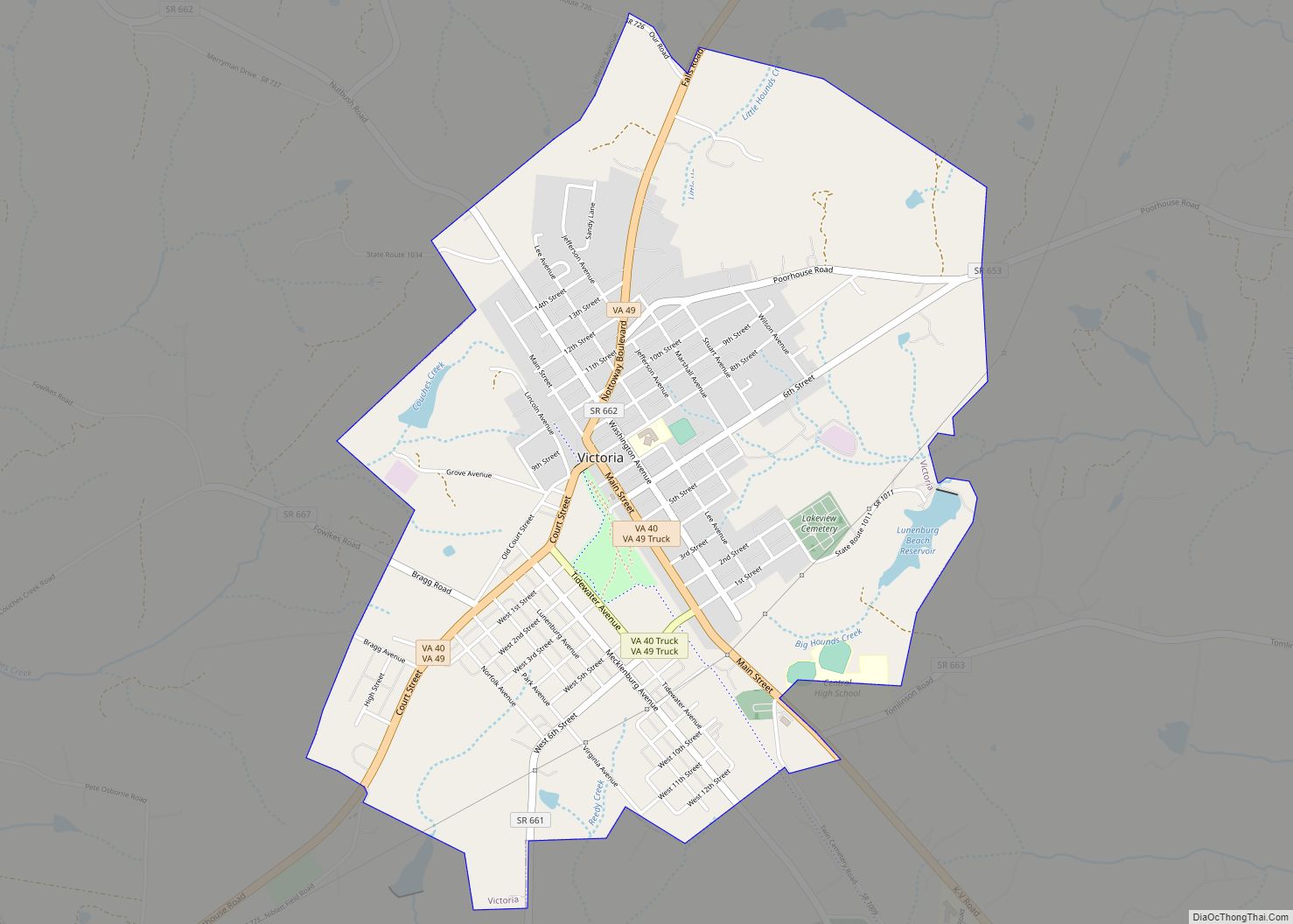
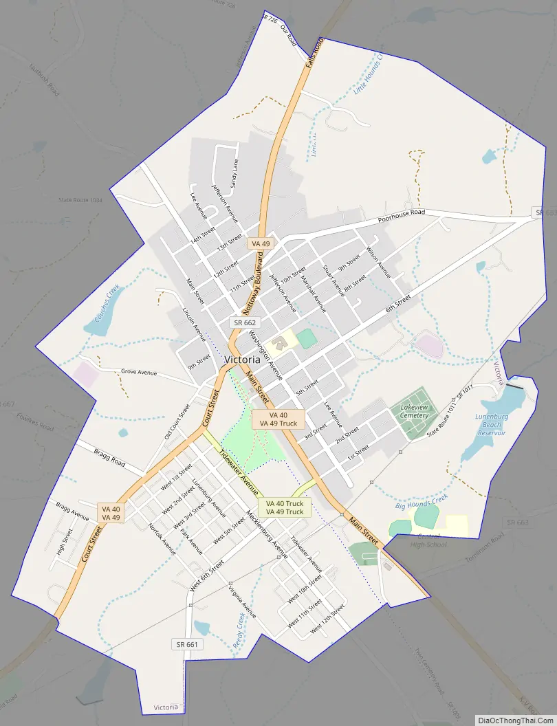
Victoria Road Map
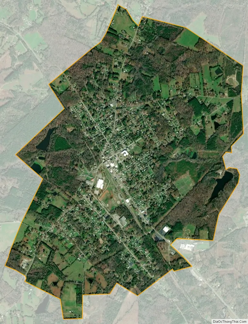
Victoria city Satellite Map
Geography
Victoria is located at 36°59′36″N 78°13′30″W / 36.99333°N 78.22500°W / 36.99333; -78.22500 (36.993365, −78.224891).
According to the United States Census Bureau, the town has a total area of 2.9 square miles (7.4 km), of which, 2.8 square miles (7.3 km) of it is land and 0.04 square miles (0.1 km) of it (1.05%) is water.
See also
Map of Virginia State and its subdivision:- Accomack
- Albemarle
- Alexandria
- Alleghany
- Amelia
- Amherst
- Appomattox
- Arlington
- Augusta
- Bath
- Bedford
- Bedford City
- Bland
- Botetourt
- Bristol
- Brunswick
- Buchanan
- Buckingham
- Buena Vista
- Campbell
- Caroline
- Carroll
- Charles City
- Charlotte
- Charlottesville
- Chesapeake
- Chesterfield
- Clarke
- Clifton Forge City
- Colonial Heights
- Covington
- Craig
- Culpeper
- Cumberland
- Danville
- Dickenson
- Dinwiddie
- Emporia
- Essex
- Fairfax
- Fairfax City
- Falls Church
- Fauquier
- Floyd
- Fluvanna
- Franklin
- Frederick
- Fredericksburg
- Galax
- Giles
- Gloucester
- Goochland
- Grayson
- Greene
- Greensville
- Halifax
- Hampton
- Hanover
- Harrisonburg
- Henrico
- Henry
- Highland
- Hopewell
- Isle of Wight
- James City
- King and Queen
- King George
- King William
- Lancaster
- Lee
- Lexington
- Loudoun
- Louisa
- Lunenburg
- Lynchburg
- Madison
- Manassas
- Manassas Park
- Martinsville
- Mathews
- Mecklenburg
- Middlesex
- Montgomery
- Nelson
- New Kent
- Newport News
- Norfolk
- Northampton
- Northumberland
- Norton
- Nottoway
- Orange
- Page
- Patrick
- Petersburg
- Pittsylvania
- Poquoson
- Portsmouth
- Powhatan
- Prince Edward
- Prince George
- Prince William
- Pulaski
- Radford
- Rappahannock
- Richmond
- Roanoke
- Roanoke City
- Rockbridge
- Rockingham
- Russell
- Salem
- Scott
- Shenandoah
- Smyth
- Southampton
- Spotsylvania
- Stafford
- Staunton
- Suffolk
- Surry
- Sussex
- Tazewell
- Virginia Beach
- Warren
- Washington
- Waynesboro
- Westmoreland
- Williamsburg
- Winchester
- Wise
- Wythe
- York
- Alabama
- Alaska
- Arizona
- Arkansas
- California
- Colorado
- Connecticut
- Delaware
- District of Columbia
- Florida
- Georgia
- Hawaii
- Idaho
- Illinois
- Indiana
- Iowa
- Kansas
- Kentucky
- Louisiana
- Maine
- Maryland
- Massachusetts
- Michigan
- Minnesota
- Mississippi
- Missouri
- Montana
- Nebraska
- Nevada
- New Hampshire
- New Jersey
- New Mexico
- New York
- North Carolina
- North Dakota
- Ohio
- Oklahoma
- Oregon
- Pennsylvania
- Rhode Island
- South Carolina
- South Dakota
- Tennessee
- Texas
- Utah
- Vermont
- Virginia
- Washington
- West Virginia
- Wisconsin
- Wyoming