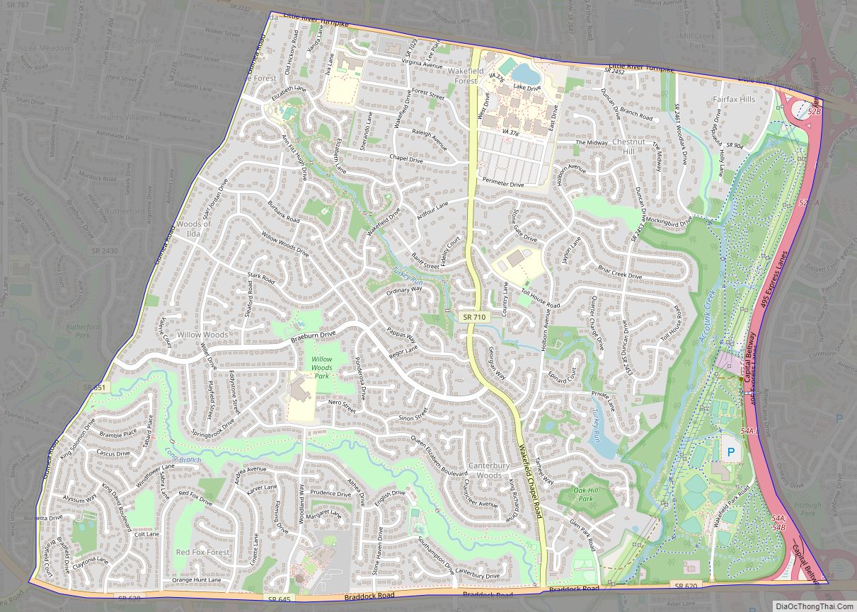
Map of Virgilina town
Virgilina is a town in Halifax County, Virginia, United States. The population was 154 at the 2010 census. Virgilina was once a copper mining town. It was a stop on the Atlantic and Danville Railway as recently as the 1950s. It is named “Virgilina” because it is located on the Virginia and North Carolina border. ... Read more
Map of Virgilina town
Map of Vinton town, Virginia
Vinton is a town in eastern Roanoke County, Virginia, United States. The population was 8,059 at the 2020 census. Vinton is part of the Roanoke Metropolitan Statistical Area and the Roanoke Region of Virginia. Vinton town overview: Name: Vinton town LSAD Code: 43 LSAD Description: town (suffix) State: Virginia County: Roanoke County Founded: 1884 Elevation: ... Read more
Map of Vinton town, Virginia
Map of Villa Heights CDP
Villa Heights is a census-designated place (CDP) in Henry County, Virginia, United States. The population was 717 at the 2010 census. It is part of the Martinsville Micropolitan Statistical Area. Villa Heights CDP overview: Name: Villa Heights CDP LSAD Code: 57 LSAD Description: CDP (suffix) State: Virginia County: Henry County Elevation: 735 ft (224 m) Total Area: ... Read more
Map of Villa Heights CDP
Map of Vienna town, Virginia
Vienna (/viˈɛnə/) is a town in Fairfax County, Virginia, United States. As of the 2020 U.S. census, Vienna has a population of 16,473. Significantly more people live in ZIP codes with the Vienna postal addresses (22180, 22181, and 22182), bordered approximately by Interstate 66 on the south, Interstate 495 on the east, Route 7 to ... Read more
Map of Vienna town, Virginia
Map of Victoria town, Virginia
Victoria is an incorporated town in Lunenburg County, Virginia, United States. The population was 1,725 at the 2010 census, which was down from the 1,821 reported in 2000. Victoria town overview: Name: Victoria town LSAD Code: 43 LSAD Description: town (suffix) State: Virginia County: Lunenburg County Elevation: 587 ft (179 m) Total Area: 2.85 sq mi (7.38 km²) Land Area: ... Read more
Map of Victoria town, Virginia
Map of Verona CDP, Virginia
Verona CDP overview: Name: Verona CDP LSAD Code: 57 LSAD Description: CDP (suffix) State: Virginia County: Augusta County FIPS code: 5180864 Online Interactive Map Verona online map. Source: Basemap layers from Google Map, Open Street Map (OSM), Arcgisonline, Wmflabs. Boundary Data from Database of Global Administrative Areas. Verona location map. Where is Verona CDP? Verona ... Read more
Map of Verona CDP, Virginia
Map of Weber City town
Weber City is an incorporated town in Scott County, Virginia, United States. The population was 1,327 at the 2010 census. It is part of the Kingsport–Bristol (TN)–Bristol (VA) Metropolitan Statistical Area, which is a component of the Johnson City–Kingsport–Bristol, TN-VA Combined Statistical Area – commonly known as the “Tri-Cities” region. Weber City town overview: Name: ... Read more
Map of Weber City town
Map of Waverly town, Virginia
Waverly is an incorporated town in Sussex County, Virginia, United States. Per the 2020 census, the population was 1,955. Waverly town overview: Name: Waverly town LSAD Code: 43 LSAD Description: town (suffix) State: Virginia County: Sussex County Elevation: 112 ft (34 m) Total Area: 3.08 sq mi (7.99 km²) Land Area: 3.08 sq mi (7.99 km²) Water Area: 0.00 sq mi (0.00 km²) Total Population: 1,955 ... Read more
Map of Waverly town, Virginia
Map of Wattsville CDP
Wattsville is a census-designated place (CDP) in Accomack County, Virginia, United States. It was first listed as a CDP in 2010. As of the 2020 census, it had a population of 1,341. Wattsville CDP overview: Name: Wattsville CDP LSAD Code: 57 LSAD Description: CDP (suffix) State: Virginia County: Accomack County Elevation: 3 ft (0.9 m) Total Area: ... Read more
Map of Wattsville CDP
Map of Washington town, Virginia
The town of Washington, Virginia, is a historic village located in the eastern foothills of the Blue Ridge Mountains near Shenandoah National Park.  The entire town is listed on the National Register of Historic Places as a historic district, Washington Historic District. It is the county seat of Rappahannock County, Virginia. The town was established ... Read more
Map of Washington town, Virginia
Map of Warsaw town, Virginia
Warsaw is an incorporated town in and the county seat of Richmond County, Virginia, United States. The population was 1,637 at the 2020 census and is estimated to be 2,281 as of 2022. Warsaw town overview: Name: Warsaw town LSAD Code: 43 LSAD Description: town (suffix) State: Virginia County: Richmond County Elevation: 131 ft (40 m) Total ... Read more
Map of Warsaw town, Virginia
Map of Warrenton town, Virginia
Warrenton is a town in Fauquier County, Virginia, of which it is the seat of government. The population was 10,057 as of the 2020 census, an increase from 9,611 at the 2010 census and 6,670 at the 2000 census. The estimated population in July 2021 was 10,109. It is at the junction of U.S. Route ... Read more
Map of Warrenton town, Virginia