Map of Naches town
Naches town overview: Name: Naches town LSAD Code: 43 LSAD Description: town (suffix) State: Washington County: Yakima County FIPS code: 5347805 Online Interactive Map Naches online map. Source: Basemap layers from Google Map, Open Street Map (OSM), Arcgisonline, Wmflabs. Boundary Data from Database of Global Administrative Areas. Naches location map. Where is Naches town? Naches ... Read more
Map of Naches town
Map of Mukilteo city
Mukilteo (/ˌmʌkəlˈtiːoʊ/ MUK-əl-TEE-oh) is a city in Snohomish County, Washington, United States. It is located on the Puget Sound between Edmonds and Everett, approximately 25 miles (40 km) north of Seattle. The city had a population of 20,254 at the 2010 census and an estimated 2019 population of 21,441. The current site of Old Town Mukilteo ... Read more
Map of Mukilteo city
Map of Moxee city
Moxee is a small suburban community southeast of Yakima, Washington. Yakima and Moxee are both north of the Yakama Indian Reservation in Yakima County, Washington, United States. The population of Moxee was 4,326 at the 2020 census. According to the Washington State Office of Financial Management, Moxee ranked 5th of 279 eligible incorporated communities in ... Read more
Map of Moxee city
Map of Mountlake Terrace city
Mountlake Terrace is a suburban city in Snohomish County, Washington, United States. It lies on the southern border of the county, adjacent to Shoreline and Lynnwood, and is 13 miles (21 km) north of Seattle. The city had a population of 19,909 people counted in the 2010 census. Mountlake Terrace was founded in 1949 by real ... Read more
Map of Mountlake Terrace city
Map of Mount Vista CDP
Mount Vista is a census-designated place (CDP) in Clark County, Washington, United States. It includes the Vancouver campus of Washington State University. The population of Mount Vista was 7,850 at the 2010 census, up from 5,770 at the 2000 census. Based on per capita income, one of the more reliable measures of affluence, Mount Vista ... Read more
Map of Mount Vista CDP
Map of Mount Vernon city, Washington
Mount Vernon is the county seat of Skagit County, Washington, United States. The population was 35,219 at the 2020 census. It is one of two principal cities of and included in the Mount Vernon-Anacortes, Washington Metropolitan Statistical Area. Downtown Mount Vernon is known for its annual Tulip Festival Street Fair, which is part of the ... Read more
Map of Mount Vernon city, Washington
Map of Moses Lake city
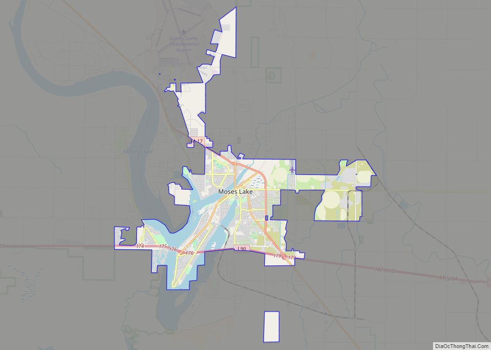
Moses Lake is a city in Grant County, Washington, United States. The population was 25,146 as of the 2020 census. Moses Lake is the largest city in Grant County. The city anchors the Moses Lake Micropolitan area, which includes all of Grant County and is part of the Moses Lake–Othello combined statistical area. Moses Lake, ... Read more
Map of Moses Lake city
Map of Newcastle city, Washington
Newcastle is an Eastside city in King County, Washington, United States. The population was 10,380 at the 2010 census and an estimated 12,292 in 2019. Although Newcastle was not incorporated until 1994, it has been an important settlement and town since the late 19th century and played a major role in the development of Seattle ... Read more
Map of Newcastle city, Washington
Map of Nespelem town
Nespelem town overview: Name: Nespelem town LSAD Code: 43 LSAD Description: town (suffix) State: Washington County: Okanogan County FIPS code: 5348540 Online Interactive Map Nespelem online map. Source: Basemap layers from Google Map, Open Street Map (OSM), Arcgisonline, Wmflabs. Boundary Data from Database of Global Administrative Areas. Nespelem location map. Where is Nespelem town? Nespelem ... Read more
Map of Nespelem town
Map of Neilton CDP
Neilton is an unincorporated community and census-designated place (CDP) in Grays Harbor County, Washington, United States. The population was 315 at the 2010 census. Neilton CDP overview: Name: Neilton CDP LSAD Code: 57 LSAD Description: CDP (suffix) State: Washington County: Grays Harbor County Elevation: 482 ft (147 m) Total Area: 9.7 sq mi (25.0 km²) Land Area: 9.7 sq mi (25.0 km²) Water ... Read more
Map of Neilton CDP
Map of Navy Yard City CDP
Navy Yard City is a census-designated place (CDP) in Kitsap County, Washington, United States. The population was 2,477 at the 2010 census. Navy Yard City CDP overview: Name: Navy Yard City CDP LSAD Code: 57 LSAD Description: CDP (suffix) State: Washington County: Kitsap County Elevation: 115 ft (35 m) Total Area: 1.0 sq mi (2.7 km²) Land Area: 0.6 sq mi (1.6 km²) ... Read more
Map of Navy Yard City CDP
Map of Nile CDP
Nile is a census-designated place and unincorporated community in Yakima County, Washington, United States, located approximately 35 miles northwest of Yakima in the Nile Valley adjacent to the Naches River in the Nile Valley, near the mouth of Rattlesnake Creek. The community was established in the mid-1890s by families of James Beck, William Markel and ... Read more
Map of Nile CDP