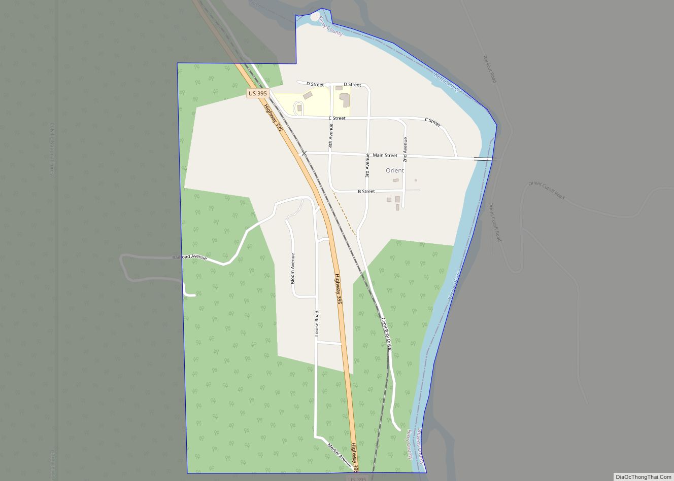
Map of Humptulips CDP

Map of Humptulips CDP

Humptulips is a census-designated place (CDP) in Grays Harbor County, Washington, United States. The population of the CDP was 255 according to the 2010 census. Humptulips CDP overview: Name: Humptulips CDP LSAD Code: 57 LSAD Description: CDP (suffix) State: Washington County: Grays Harbor County Elevation: 161 ft (49 m) Total Area: 9.5 sq mi (24.5 km²) Land Area: 9.5 sq mi (24.5 km²) … Read more

Map of Hoquiam city

Map of Hoquiam city

Hoquiam (/ˈhoʊkwiəm/ HOH-kwee-əm) is a city in Grays Harbor County, Washington, United States. It borders the city of Aberdeen at Myrtle Street, with Hoquiam to the west. The two cities share a common economic history in lumbering and exporting, but Hoquiam has maintained its independent identity. It shares a long rivalry with its more populated … Read more

Map of Hoodsport CDP

Map of Hoodsport CDP

Hoodsport is a census-designated place (CDP) in Mason County, Washington, United States. The population was 376 at the 2010 census. Hoodsport is located along the Hood Canal, at the intersection of U.S. Route 101 and State Route 119. Lake Cushman is 5 miles (8.0 km) up the road on State Route 119. Hoodsport is the gateway … Read more

Map of Home CDP, Washington

Map of Home CDP, Washington

Home is a census-designated place in Pierce County, Washington, United States. The 2010 Census placed the population at 1,377. The community lies on the Key Peninsula and borders the waters of Carr Inlet, an extension of Puget Sound. Home is now primarily a town of beach homes, although around the turn of the twentieth century, … Read more

Map of Kapowsin CDP

Map of Kapowsin CDP

Kapowsin /kəˈpaʊ.ə.sɪn/ is a census-designated place located approximately 25 miles (38 kilometers) southeast of Tacoma in Pierce County, Washington, United States. The 2020 Census placed the population at 249. Kapowsin, originally Kapousen Precint, was named for its shallow lake. The ancient glacial drainage channel provides a nearly level connection between the Puyallup and Nisqually Rivers, … Read more

Map of Kalama city

Map of Kalama city

Kalama (kaw-law-maw) is a city in Cowlitz County, Washington, United States. It is part of the Longview, Washington Metropolitan Statistical Area. The population was 2,959 as of the 2020 census. Kalama city overview: Name: Kalama city LSAD Code: 25 LSAD Description: city (suffix) State: Washington County: Cowlitz County Elevation: 39 ft (12 m) Total Area: 3.83 sq mi (9.91 km²) … Read more

Map of Kahlotus city

Map of Kahlotus city

Kahlotus (/kəˈloʊdəs/) is a city in Franklin County, Washington, United States. The population was 193 at the 2010 census. The Washington State Office of Financial Management’s 2015 estimate placed the population at 190. Kahlotus city overview: Name: Kahlotus city LSAD Code: 25 LSAD Description: city (suffix) State: Washington County: Franklin County Elevation: 902 ft (275 m) Total … Read more

Map of Junction City CDP, Washington

Map of Junction City CDP, Washington

Junction City is a census-designated place (CDP) in Grays Harbor County, Washington, United States. The population was 18 at the 2010 census. Junction City CDP overview: Name: Junction City CDP LSAD Code: 57 LSAD Description: CDP (suffix) State: Washington County: Grays Harbor County Elevation: 30 ft (9 m) Total Area: 1.61 sq mi (4.16 km²) Land Area: 1.42 sq mi (3.67 km²) Water … Read more

Map of Jamestown CDP, Washington

Map of Jamestown CDP, Washington

Jamestown is an unincorporated community and census-designated place (CDP) in Clallam County, Washington, United States. The population was 361 at the 2010 census. The community derives its name from Chief James, a Clallam Indian leader. Jamestown CDP overview: Name: Jamestown CDP LSAD Code: 57 LSAD Description: CDP (suffix) State: Washington County: Clallam County Elevation: 10 ft … Read more

Map of Issaquah city

Map of Issaquah city

Issaquah (/ˈɪsəkwɑː/ ISS-ə-kwah) is a city in King County, Washington, United States. The population was 40,051 at the 2020 census. Located in a valley and bisected by Interstate 90, the city is bordered by the Sammamish Plateau to the north and the “Issaquah Alps” to the south. It is home to the headquarters of the … Read more

Map of Ione town, Washington

Map of Ione town, Washington

Ione town overview: Name: Ione town LSAD Code: 43 LSAD Description: town (suffix) State: Washington County: Pend Oreille County FIPS code: 5333560 Online Interactive Map Ione online map. Source: Basemap layers from Google Map, Open Street Map (OSM), Arcgisonline, Wmflabs. Boundary Data from Database of Global Administrative Areas. Ione location map. Where is Ione town? … Read more

Map of Indianola CDP, Washington

Map of Indianola CDP, Washington

Indianola is a census-designated place (CDP) in Kitsap County, Washington, United States, located on the north shore of Port Madison on the Port Madison Indian Reservation, home of the Suquamish Indian Tribe. The population was 3,500 at the 2010 census. It was originally established as a summer community and was a stop for Mosquito Fleet … Read more