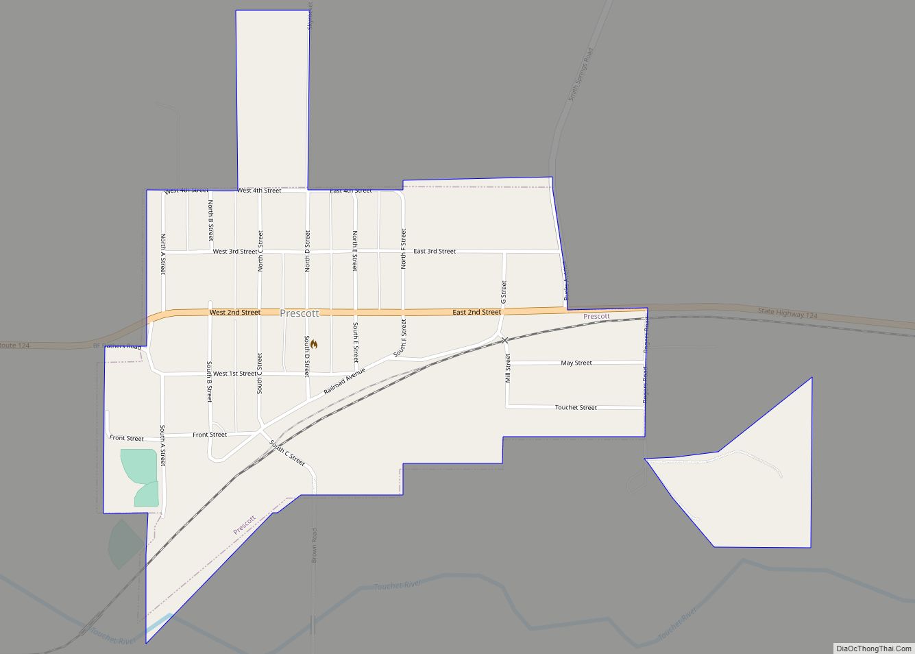
Map of Lake Cavanaugh CDP

Map of Lake Cavanaugh CDP

Lake Cavanaugh is a census-designated place (CDP) in Skagit County, Washington, United States. The population was 167 at the 2010 census. It is included in the Mount Vernon–Anacortes, Washington Metropolitan Statistical Area. Based on per capita income, Lake Cavanaugh ranks 30th of 522 areas in the state of Washington to be ranked. It is also … Read more

Map of Lake Shore CDP, Washington

Map of Lake Shore CDP, Washington

Lake Shore is a census-designated place (CDP) in Clark County, Washington, United States. The population was 6,571 at the 2010 census. Based on per capita income, one of the more reliable measures of affluence, Lake Shore ranks 124th of 614 areas in the state of Washington to be ranked. Lake Shore CDP overview: Name: Lake … Read more

Map of Lake Roesiger CDP

Map of Lake Roesiger CDP

Lake Roesiger is a census-designated place (CDP) in Snohomish County, Washington, United States. The population was 503 at the 2010 census. Based on per capita income, one of the more reliable measures of affluence, Lake Roesiger ranks 98th of 522 areas in the state of Washington to be ranked. Lake Roesiger CDP overview: Name: Lake … Read more

Map of Lake Morton-Berrydale CDP

Map of Lake Morton-Berrydale CDP

Lake Morton-Berrydale is a census-designated place (CDP) in King County, Washington, United States. The population was 10,474 at the 2020 census. Based on per capita income, one of the more reliable measures of affluence, Lake Morton-Berrydale ranks 44th of 522 areas in the state of Washington to be ranked. Lake Morton-Berrydale CDP overview: Name: Lake … Read more

Map of Lake McMurray CDP

Map of Lake McMurray CDP

Lake McMurray is a census-designated place (CDP) in Skagit County, Washington, United States. The population was 192 at the 2010 census. It is included in the Mount Vernon–Anacortes, Washington Metropolitan Statistical Area. Based on per capita income, Lake McMurray ranks 43rd of 522 ranked areas in the state of Washington. It is part of the … Read more

Map of Lake Marcel-Stillwater CDP

Map of Lake Marcel-Stillwater CDP

Lake Marcel-Stillwater is a census-designated place (CDP) in King County, Washington, United States. The population was 1,277 at the 2010 census. Lake Marcel-Stillwater CDP overview: Name: Lake Marcel-Stillwater CDP LSAD Code: 57 LSAD Description: CDP (suffix) State: Washington County: King County Elevation: 300 ft (90 m) Total Area: 1.33 sq mi (3.45 km²) Land Area: 1.27 sq mi (3.30 km²) Water Area: 0.06 sq mi … Read more

Map of Lake Ketchum CDP

Map of Lake Ketchum CDP

Lake Ketchum is a census-designated place (CDP) in Snohomish County, Washington, United States. The population was 930 at the 2010 census. Lake Ketchum CDP overview: Name: Lake Ketchum CDP LSAD Code: 57 LSAD Description: CDP (suffix) State: Washington County: Snohomish County Elevation: 230 ft (70 m) Total Area: 3.1 sq mi (8.1 km²) Land Area: 3.1 sq mi (8.1 km²) Water Area: 0.0 sq mi … Read more

Map of Larch Way CDP

Map of Larch Way CDP

Larch Way is a census-designated place (CDP) located in Snohomish County, Washington. Larch Way CDP overview: Name: Larch Way CDP LSAD Code: 57 LSAD Description: CDP (suffix) State: Washington County: Snohomish County Elevation: 505 ft (154 m) Total Area: 1.11 sq mi (2.9 km²) Total Population: 3,318 Population Density: 3,000/sq mi (1,100/km²) Area code: 360 FIPS code: 5338420 Online Interactive Map … Read more

Map of Langley city, Washington

Map of Langley city, Washington

Langley is a city in Island County, Washington, United States. It sits near the south end of Whidbey Island, overlooking the Saratoga Passage. It is the third largest incorporated area on Whidbey. The population was 1,035 at the 2010 census, while the ZCTA for Langley’s post office had a population of 4,878. The geographical area … Read more

Map of Lamont town, Washington

Map of Lamont town, Washington

Lamont town overview: Name: Lamont town LSAD Code: 43 LSAD Description: town (suffix) State: Washington County: Whitman County FIPS code: 5338215 Online Interactive Map Lamont online map. Source: Basemap layers from Google Map, Open Street Map (OSM), Arcgisonline, Wmflabs. Boundary Data from Database of Global Administrative Areas. Lamont location map. Where is Lamont town? Lamont … Read more

Map of Lakewood city, Washington

Map of Lakewood city, Washington

Lakewood is a city in Pierce County, Washington, United States. The population was 63,612 at the 2020 census. Lakewood city overview: Name: Lakewood city LSAD Code: 25 LSAD Description: city (suffix) State: Washington County: Pierce County Elevation: 262 ft (80 m) Total Area: 18.89 sq mi (48.93 km²) Land Area: 17.06 sq mi (44.18 km²) Water Area: 1.83 sq mi (4.74 km²)  9.39% Total Population: 63,612 … Read more

Map of Lakeview CDP, Washington

Map of Lakeview CDP, Washington

Lakeview is a census-designated place (CDP) in Grant County, Washington, United States. The population was 915 at the 2010 census, up from 797 at the 2000 census. The community is referred to as Lakeview Park on topographic maps and by locals. Lakeview CDP overview: Name: Lakeview CDP LSAD Code: 57 LSAD Description: CDP (suffix) State: … Read more