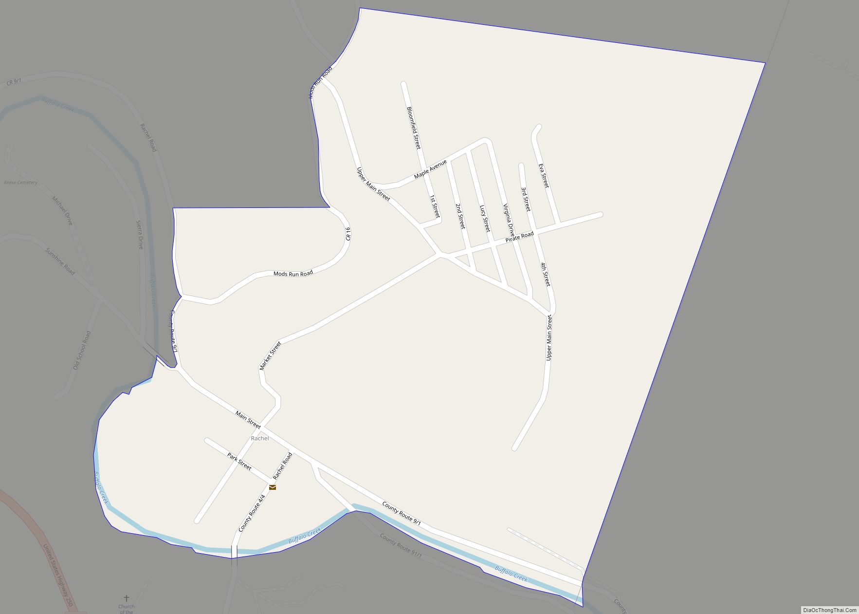
Map of Inwood CDP, West Virginia

Map of Inwood CDP, West Virginia

Inwood is a census-designated place (CDP) in Berkeley County, West Virginia, United States, located south of Martinsburg in the lower Shenandoah Valley. The population was 2,954 at the 2010 census. It is located on U.S. Route 11. Inwood CDP overview: Name: Inwood CDP LSAD Code: 57 LSAD Description: CDP (suffix) State: West Virginia County: Berkeley … Read more

Map of Hendricks town, West Virginia

Map of Hendricks town, West Virginia

Hendricks is a town in Tucker County, West Virginia, United States. The population was 226 at the 2020 census. The Blackwater River and the Dry Fork join at Hendricks to form the Black Fork, a principal tributary of the Cheat River. Hendricks town overview: Name: Hendricks town LSAD Code: 43 LSAD Description: town (suffix) State: … Read more

Map of Idamay CDP

Map of Idamay CDP

Idamay is a census-designated place (CDP) in Marion County, West Virginia, United States. Idamay is located along West Virginia Route 218, 1 mile (1.6 km) south of Farmington. Idamay has a post office with ZIP code 26576. As of the 2010 census, its population was 611. Idamay CDP overview: Name: Idamay CDP LSAD Code: 57 LSAD … Read more

Map of Iaeger town

Map of Iaeger town

Iaeger (pronounced YAY-ger) is a town in McDowell County, West Virginia, United States. The population was 257 at the 2020 census. Iaeger town overview: Name: Iaeger town LSAD Code: 43 LSAD Description: town (suffix) State: West Virginia County: McDowell County Elevation: 984 ft (300 m) Total Area: 0.84 sq mi (2.16 km²) Land Area: 0.79 sq mi (2.05 km²) Water Area: 0.04 sq mi (0.11 km²) … Read more

Map of Huttonsville town

Map of Huttonsville town

Huttonsville is a town in Randolph County, West Virginia, United States, along the Tygart Valley River. The population was 163 at the 2020 census. Huttonsville town overview: Name: Huttonsville town LSAD Code: 43 LSAD Description: town (suffix) State: West Virginia County: Randolph County Elevation: 2,037 ft (621 m) Total Area: 0.30 sq mi (0.78 km²) Land Area: 0.30 sq mi (0.78 km²) Water … Read more

Map of Hurricane city, West Virginia

Map of Hurricane city, West Virginia

Hurricane (/ˈhɜːrʌkɪn/ HUR-uh-kin) is a city in Putnam County, West Virginia, United States. The population was 6,977 at the 2020 census. Located roughly equidistant from Charleston and Huntington, it is part of the Huntington–Ashland metropolitan area. Hurricane city overview: Name: Hurricane city LSAD Code: 25 LSAD Description: city (suffix) State: West Virginia County: Putnam County … Read more

Map of Huntersville CDP, West Virginia

Map of Huntersville CDP, West Virginia

Huntersville is a census-designated place (CDP) located in Pocahontas County, West Virginia, United States in the Alleghany Mountains. As of the 2010 census, its population was 73. It is located six miles east of Marlinton and four miles west of Minnehaha Springs. Huntersville received its name because it was a rendezvous for trappers and hunters … Read more

Map of Hundred town

Map of Hundred town

Hundred is a town in Wetzel County, West Virginia, United States. The population was 257 at the 2020 census. It was named for the fact that local resident Henry “Old Hundred” Church was a centenarian. Hundred is the only place in the United States with this name. Hundred town overview: Name: Hundred town LSAD Code: … Read more

Map of Keyser city

Map of Keyser city

Keyser (/ˈkaɪ.zər/) is a city in and the county seat of Mineral County, West Virginia. It is part of the Cumberland, MD-WV Metropolitan Statistical Area. The population was 4,853 at the 2020 census. Keyser city overview: Name: Keyser city LSAD Code: 25 LSAD Description: city (suffix) State: West Virginia County: Mineral County Elevation: 807 ft (246 m) … Read more

Map of Kermit town, West Virginia

Map of Kermit town, West Virginia

Kermit is a town in Mingo County, West Virginia, United States. The population was 406 at the 2010 census. Kermit is located along the Tug Fork, opposite Warfield, Kentucky. The Norfolk Southern Railway’s Kenova District runs through town. The community was earlier known by the names “Lower Burning Creek”, “East Warfield,” and “Warfield.” The name … Read more

Map of Littleton CDP, West Virginia

Map of Littleton CDP, West Virginia

Littleton is a census-designated place (CDP) in Wetzel County, West Virginia, United States. The population was 198 at the 2010 census. Littleton CDP overview: Name: Littleton CDP LSAD Code: 57 LSAD Description: CDP (suffix) State: West Virginia County: Wetzel County Elevation: 925 ft (282 m) Total Area: 0.7 sq mi (1.7 km²) Land Area: 0.7 sq mi (1.7 km²) Water Area: 0.0 sq mi (0.0 km²) … Read more

Map of Kenova city

Map of Kenova city

Kenova is a city in Wayne County, West Virginia, United States, situated at the confluence of the Ohio and Big Sandy rivers. The city’s name is a portmanteau of Kentucky, Ohio, and Virginia (Va), owing to its location where the three states met before the creation of West Virginia. The population was 3,030 at the … Read more