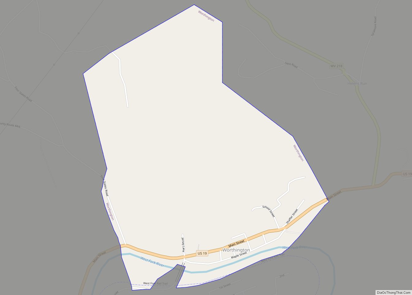
Map of Parcoal CDP

Map of Parcoal CDP

Parcoal CDP overview: Name: Parcoal CDP LSAD Code: 57 LSAD Description: CDP (suffix) State: West Virginia FIPS code: 5462044 Online Interactive Map Parcoal online map. Source: Basemap layers from Google Map, Open Street Map (OSM), Arcgisonline, Wmflabs. Boundary Data from Database of Global Administrative Areas. Parcoal location map. Where is Parcoal CDP? Parcoal Road Map … Read more

Map of New Haven town, West Virginia

Map of New Haven town, West Virginia

New Haven is a town in Mason County, West Virginia, United States, along the Ohio River. The population was 1,485 at the 2020 census. It is part of the Point Pleasant, WV–OH Micropolitan Statistical Area. The town was named after New Haven, Connecticut, the native home of the local mine proprietors. New Haven town overview: … Read more

Map of Pageton CDP

Map of Pageton CDP

Pageton is a census-designated place (CDP) in McDowell County, West Virginia, United States. As of the 2010 census, its population was 187. Pageton is located on the Tug Fork Branch of the Norfolk and Western Railway, along the Pocahontas seam of rich bituminous coal. Pageton is located on State Route 161 between Thorpe and Anawalt. … Read more

Map of New Cumberland city, West Virginia

Map of New Cumberland city, West Virginia

New Cumberland is a city in and the county seat of Hancock County, West Virginia, United States, along the Ohio River. The population was 1,020 as of the 2020 census. It is part of the Weirton–Steubenville metropolitan area. New Cumberland city overview: Name: New Cumberland city LSAD Code: 25 LSAD Description: city (suffix) State: West … Read more

Map of Page CDP, West Virginia

Map of Page CDP, West Virginia

Page is a census-designated place (CDP) and coal town in Fayette County, West Virginia, United States. As of the 2010 census, its population was 224. It was named for William Nelson Page (1854-1932), a civil engineer and industrialist who lived in nearby Ansted, where he managed Gauley Mountain Coal Company and many iron, coal, and … Read more

Map of Nettie CDP

Map of Nettie CDP

Nettie is a census-designated place (CDP) in Nicholas County, West Virginia, United States. Nettie is the location of the southern convergence of state routes 20 and 39. As of the 2020 census, its population was 494. Nettie CDP overview: Name: Nettie CDP LSAD Code: 57 LSAD Description: CDP (suffix) State: West Virginia County: Nicholas County … Read more

Map of Paden City city

Map of Paden City

Paden City is a city in Tyler and Wetzel counties in the U.S. state of West Virginia, along the Ohio River. It was founded in 1902. The population was 2,550 at the 2020 census. The town was named for Pennsylvania-born Obediah Paden (1755-1822), a local landowner. Nearby Paden Island and Paden Fork were also named … Read more

Map of Omar CDP

Map of Omar CDP

Omar is an unincorporated community and census-designated place (CDP) in Logan County, West Virginia, United States. Omar is located along West Virginia Route 44 and Island Creek, 6.5 miles (10.5 km) south of Logan. Omar has a post office with ZIP code 25638. As of the 2010 census, its population was 552. The community was named … Read more

Map of Oceana town

Map of Oceana town

Oceana is a town in Wyoming County, West Virginia. The population was 1,462 at the time of the 2020 census. Oceana is the oldest city in Wyoming County and was the county seat until 1907. Oceana was the eponym of the film Oxyana. The town has a town hall and a local police department. It … Read more

Map of Oakvale town

Map of Oakvale town

Oakvale is a town in Mercer County, West Virginia, United States, along the East River. The population was 137 at the 2020 census. It is part of the Bluefield, WV-VA micropolitan area which has a population of 107,578. Oakvale town overview: Name: Oakvale town LSAD Code: 43 LSAD Description: town (suffix) State: West Virginia County: … Read more

Map of Oak Hill city, West Virginia

Map of Oak Hill city, West Virginia

Oak Hill is a city in Fayette County, West Virginia, United States. The population was 8,179 at the 2020 census. It is part of the Beckley metropolitan area. The city is also home to the historic Oak Hill Railroad Depot which still stands today as an artisan shop. Country singer Hank Williams died in Oak … Read more

Map of Nutter Fort town

Map of Nutter Fort town

Nutter Fort is a town in Harrison County, West Virginia, United States, incorporated in 1923. The town is a southeastern suburb of Clarksburg. Since 1996, Nutter Fort has held the West Virginia Blackberry Festival during the first weekend of August. The population was 1,497 at the 2020 census. The town is also home to the … Read more