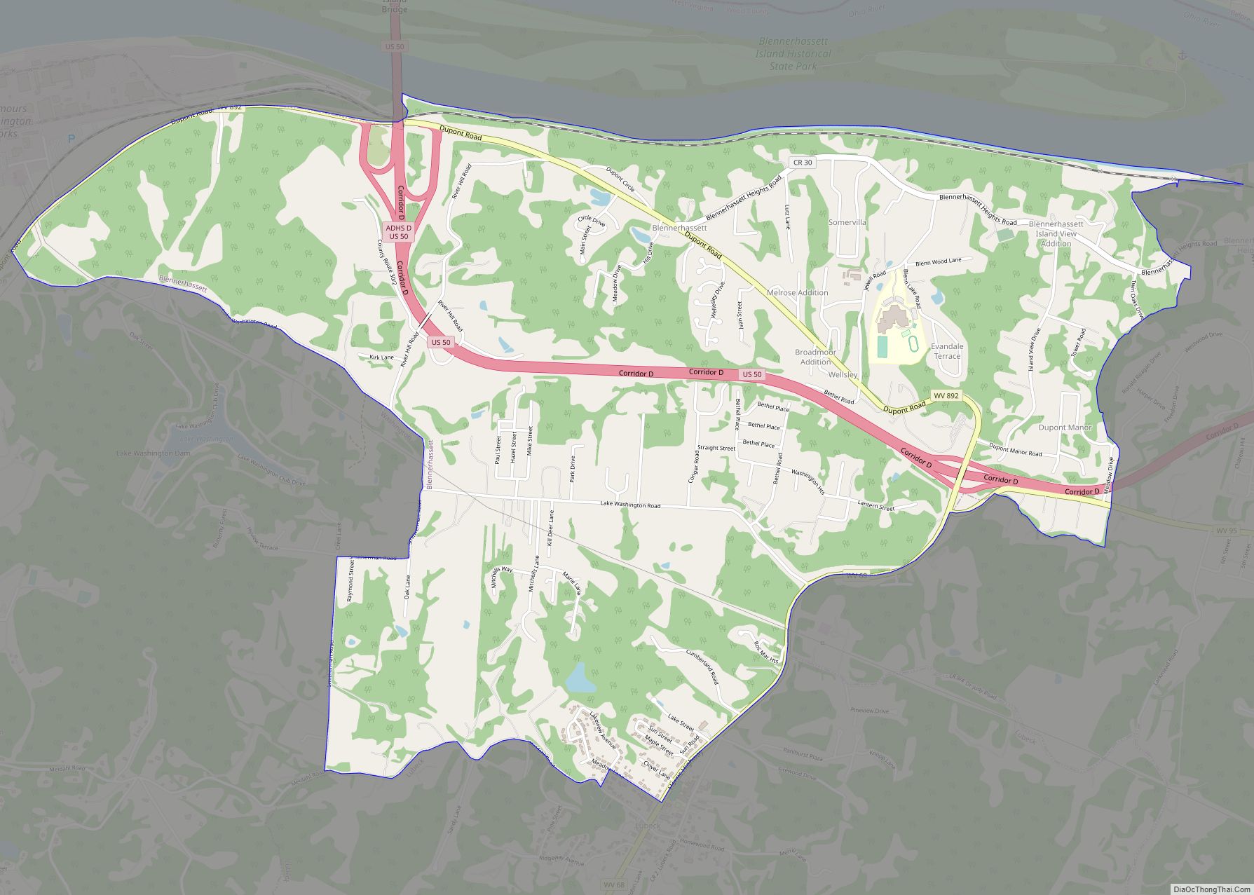
Map of Richwood city, West Virginia

Map of Richwood city, West Virginia

Richwood is a city in Nicholas County, West Virginia, United States. In 2020, the census showed Richwood with a population of 1,661. During the 19th and early 20th century Richwood was a booming coal and lumber town. Richwood has a very rich history, including the formation of the Cherry River Navy civic organization to draw … Read more

Map of Princeton city, West Virginia

Map of Princeton city, West Virginia

Princeton, is a city in and the county seat of Mercer County, West Virginia, United States. The population was 5,872 at the 2020 census. It is part of the Bluefield micropolitan area. The city hosts the Princeton WhistlePigs baseball club of the Appalachian League. Princeton city overview: Name: Princeton city LSAD Code: 25 LSAD Description: … Read more

Map of Rhodell town

Map of Rhodell town

Rhodell is an unincorporated community in Raleigh County, West Virginia, United States. The population was 173 at the 2010 census. Rhodell town overview: Name: Rhodell town LSAD Code: 43 LSAD Description: town (suffix) State: West Virginia County: Raleigh County Elevation: 1,627 ft (496 m) Total Area: 0.31 sq mi (0.81 km²) Land Area: 0.31 sq mi (0.81 km²) Water Area: 0.00 sq mi (0.00 km²) Total … Read more

Map of Prince CDP

Map of Prince CDP

Prince is a census-designated place (CDP) in Fayette County, West Virginia, United States. As of the 2010 census, its population was 116. Located at an altitude of 1,263 feet (385 m), it is served by an Amtrak station. The community was named after William Prince, an early settler. Prince CDP overview: Name: Prince CDP LSAD Code: 57 … Read more

Map of Reedy town

Map of Reedy town

Reedy is a town in Roane County, West Virginia, United States. The population was 152 at the 2020 census. The community was named after nearby Reedy Creek. Reedy town overview: Name: Reedy town LSAD Code: 43 LSAD Description: town (suffix) State: West Virginia County: Roane County Elevation: 679 ft (207 m) Total Area: 0.20 sq mi (0.50 km²) Land Area: … Read more

Map of Reedsville town, West Virginia

Map of Reedsville town, West Virginia

Reedsville is a town in western Preston County, West Virginia, United States. The population was 530 at the 2020 census. It is part of the Morgantown metropolitan area. Reedsville town overview: Name: Reedsville town LSAD Code: 43 LSAD Description: town (suffix) State: West Virginia County: Preston County Elevation: 1,818 ft (554 m) Total Area: 0.65 sq mi (1.68 km²) Land … Read more

Map of Red Jacket CDP

Map of Red Jacket CDP

Red Jacket is a census-designated place (CDP) in Mingo County, West Virginia, United States. The population was 581 at the 2010 census. The community was named for Red Jacket, a Seneca chief. Red Jacket CDP overview: Name: Red Jacket CDP LSAD Code: 57 LSAD Description: CDP (suffix) State: West Virginia County: Mingo County Elevation: 794 ft … Read more

Map of Reader CDP, West Virginia

Map of Reader CDP, West Virginia

Reader is a census-designated place (CDP) in Wetzel County, West Virginia, United States. As of the 2010 census, its population was 397. Reader got its start circa 1901 when the railroad was extended to that point. The community took its name from nearby Reader Run creek. Reader CDP overview: Name: Reader CDP LSAD Code: 57 … Read more

Map of Raysal CDP

Map of Raysal CDP

Raysal is a census-designated place (CDP) in McDowell County, West Virginia, United States. Raysal is located along West Virginia Route 83, 1 mile (1.6 km) southeast of Bradshaw. Raysal has a post office with ZIP code 24879. As of the 2010 census, its population was 465. The community’s name is an amalgamation of Raymond Salvati, a … Read more

Map of Ravenswood city

Map of Ravenswood city

Ravenswood is a city in Jackson County, West Virginia, United States, along the Ohio River. The population was 3,865 at the 2020 census. Ravenswood city overview: Name: Ravenswood city LSAD Code: 25 LSAD Description: city (suffix) State: West Virginia County: Jackson County Elevation: 607 ft (185 m) Total Area: 1.89 sq mi (4.89 km²) Land Area: 1.82 sq mi (4.71 km²) Water Area: … Read more

Map of Ranson corporation

Map of Ranson corporation

Ranson is a city in Jefferson County, West Virginia, United States. The population was 5,433 at the 2020 census. It is part of the northwestern fringes of the Washington metropolitan area. Ranson corporation overview: Name: Ranson corporation LSAD Code: CN LSAD Description: corporation (suffix) State: West Virginia County: Jefferson County Total Area: 8.09 sq mi (20.96 km²) Land … Read more

Map of Rand CDP

Map of Rand CDP

Rand is a census-designated place (CDP) on the Kanawha River in Kanawha County, West Virginia, United States. As of the 2010 census, its population was 1,631. It is surrounded by the communities of Malden and DuPont City. Rand CDP overview: Name: Rand CDP LSAD Code: 57 LSAD Description: CDP (suffix) State: West Virginia County: Kanawha … Read more