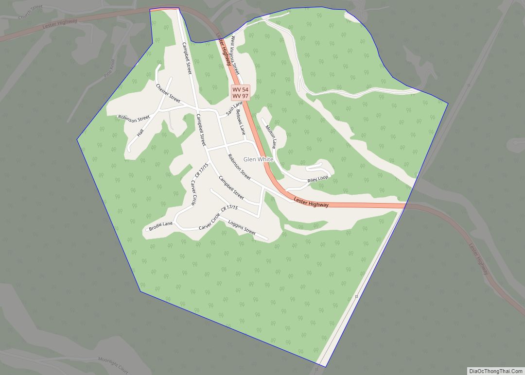
Map of Glen Ferris CDP
Glen Ferris is a census-designated place (CDP) on the western bank of the Kanawha River in Fayette County, West Virginia, United States. It is situated approximately one mile south of the town of Gauley Bridge and adjacent to Kanawha Falls. The sole highway linking Glen Ferris to the area is U.S. Route 60, known also ... Read more
Map of Glen Ferris CDP
Map of Glasgow town, West Virginia
Glasgow is a town in Kanawha County, West Virginia, United States, situated along the Kanawha River. The population was 708 at the 2020 census. Glasgow was incorporated on June 20, 1920. Folk etymology derives its name from a combination of the word “glass” with the word “company” for a glass factory that was built there ... Read more
Map of Glasgow town, West Virginia
Map of Gassaway town
Gassaway is a town in Braxton County, West Virginia, United States. The population was 769 at the 2020 census. Gassaway was incorporated in 1905 and named for Henry Gassaway Davis, the Democratic Party’s nominee for Vice President of the United States in 1904. The center of population of West Virginia is located approximately 7 miles ... Read more
Map of Gassaway town
Map of Granville town, West Virginia
Granville is a town in Monongalia County, West Virginia, United States. The population was 1,355 at the 2020 census. It is included in the Morgantown metropolitan area. Granville town overview: Name: Granville town LSAD Code: 43 LSAD Description: town (suffix) State: West Virginia County: Monongalia County Elevation: 814 ft (248 m) Total Area: 1.30 sq mi (3.36 km²) Land Area: ... Read more
Map of Granville town, West Virginia
Map of Helen CDP, West Virginia
Helen is a census-designated place (CDP) in Raleigh County, West Virginia, United States. As of the 2010 census, its population was 219. West Virginia Route 16, Winding Gulf and railroad tracks run right through the community. The Helen mine and coal camp was opened in the 1910s by the East Gulf Coal Company. Many years ... Read more
Map of Helen CDP, West Virginia
Map of Grantsville town, West Virginia
Grantsville is a town in Calhoun County, West Virginia, United States. The population was 482 at the 2020 census. It is the county seat of Calhoun County. The town was established along the Little Kanawha River in 1865 and named for Ulysses S. Grant. Grantsville is home to Wayne Underwood Park, which includes a .25-mile-long ... Read more
Map of Grantsville town, West Virginia
Map of Hedgesville town
Hedgesville is a town in Berkeley County, West Virginia, United States, in the state’s Eastern Panhandle region. The population was 318 at the 2010 census. The town sits on WV 9, and is roughly 13 miles east of Berkeley Springs. In addition to its legal definition, Hedgesville has come to be the common name for ... Read more
Map of Hedgesville town
Map of Harts CDP
Harts is a census-designated place (CDP) at the mouth of Big Harts Creek in Lincoln County, West Virginia, United States, situated along the Guyandotte River. As of the 2010 census, its population was 656. Harts is a part of the Huntington-Ashland, WV-KY-OH, Metropolitan Statistical Area (MSA). The Harts CDP includes the unincorporated communities of Harts, ... Read more
Map of Harts CDP
Map of Harrisville town, West Virginia
Harrisville is a town in Ritchie County, West Virginia, United States. It is the county seat of Ritchie County. Harrisville is located at the junction of State Routes 31 and 16, five miles south of U.S. 50. Within the community are an elementary school, the county board of education, many businesses, three banks, a library, ... Read more
Map of Harrisville town, West Virginia
Map of Harpers Ferry town, West Virginia
Harpers Ferry is a historic town in Jefferson County, West Virginia, United States, in the lower Shenandoah Valley. The population was 285 at the 2020 census. Situated at the confluence of the Potomac and Shenandoah rivers, where the U.S. states of Maryland, Virginia, and West Virginia meet, it is the easternmost town in West Virginia. ... Read more
Map of Harpers Ferry town, West Virginia
Map of Handley town
Handley is a town in Kanawha County, West Virginia, United States. The population was 224 at the 2020 census. Handley was first established in 1877 and known as Upper Creek until July 29, 1881, when its name was changed to Handley for pioneer settlers who farmed the area. Handley has the distinction of bearing a ... Read more
Map of Handley town
Map of Hamlin town, West Virginia
Hamlin is a town in and the county seat of Lincoln County, West Virginia, United States, along the Mud River. The population was recorded as 1,040 at the 2020 census. It is part of the Huntington–Ashland metropolitan area. Hamlin town overview: Name: Hamlin town LSAD Code: 43 LSAD Description: town (suffix) State: West Virginia County: ... Read more
Map of Hamlin town, West Virginia