Map of Hawkins village, Wisconsin
Hawkins is a town in Rusk County, Wisconsin, United States. The population was 170 at the 2000 census. The Village of Hawkins is located within the town. Hawkins village overview: Name: Hawkins village LSAD Code: 47 LSAD Description: village (suffix) State: Wisconsin County: Rusk County FIPS code: 5533275 Online Interactive Map Hawkins online map. Source: ... Read more
Map of Hawkins village, Wisconsin
Map of Hatley village, Wisconsin
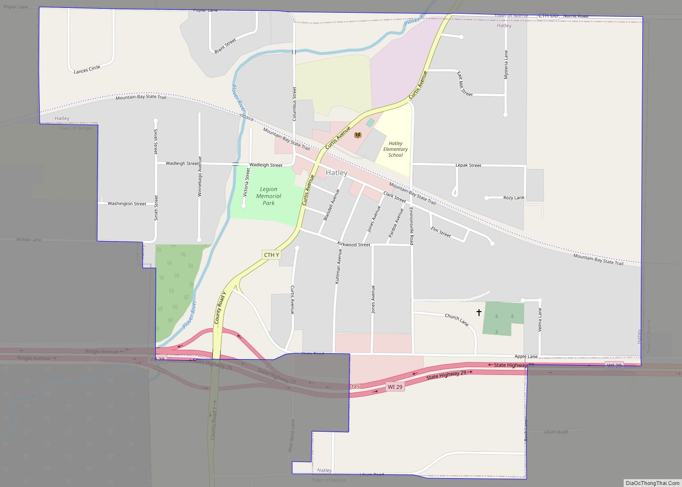
Hatley is a village in Marathon County, Wisconsin, United States. It is part of the Wausau, Wisconsin Metropolitan Statistical Area. The population was 574 at the 2010 census. Hatley village overview: Name: Hatley village LSAD Code: 47 LSAD Description: village (suffix) State: Wisconsin County: Marathon County Elevation: 1,270 ft (387 m) Total Area: 0.98 sq mi (2.53 km²) Land Area: ... Read more
Map of Hatley village, Wisconsin
Map of Hatfield CDP, Wisconsin
Hatfield is an unincorporated census-designated place, in the town of Komensky, Jackson County, Wisconsin, United States. As of the 2010 census, its population is 141. Hatfield CDP overview: Name: Hatfield CDP LSAD Code: 57 LSAD Description: CDP (suffix) State: Wisconsin County: Jackson County Elevation: 889 ft (271 m) Total Area: 1.337 sq mi (3.46 km²) Land Area: 1.337 sq mi (3.46 km²) Water ... Read more
Map of Hatfield CDP, Wisconsin
Map of Harrison village, Wisconsin
Harrison is a village in Calumet and Outagamie Counties, Wisconsin, United States. The village was created on March 8, 2013, from unincorporated areas of the Town of Harrison and a portion of the Town of Buchanan: the right of way along County Trunk Highway KK in Outagamie County. The village is located in what was ... Read more
Map of Harrison village, Wisconsin
Map of Hillsboro city, Wisconsin
Hillsboro is a city in Vernon County, Wisconsin, United States. The population was 1,397 at the 2020 Census. The city is located within the Town of Hillsboro. Hillsboro is known as the Czech Capital of Wisconsin. Hillsboro city overview: Name: Hillsboro city LSAD Code: 25 LSAD Description: city (suffix) State: Wisconsin County: Vernon County Total ... Read more
Map of Hillsboro city, Wisconsin
Map of Hustisford village
Hustisford is a town in Dodge County, Wisconsin, United States. The population was 1,379 at the 2000 census. Most of the town residents live in the village of Hustisford, within the town. Hustisford village overview: Name: Hustisford village LSAD Code: 47 LSAD Description: village (suffix) State: Wisconsin County: Dodge County Elevation: 846 ft (258 m) Total Area: ... Read more
Map of Hustisford village
Map of Hilbert village
Hilbert is a village in Calumet County in the U.S. state of Wisconsin. The population was 1,132 at the 2010 census. Hilbert village overview: Name: Hilbert village LSAD Code: 47 LSAD Description: village (suffix) State: Wisconsin County: Calumet County Elevation: 837 ft (255 m) Total Area: 1.47 sq mi (3.82 km²) Land Area: 1.47 sq mi (3.82 km²) Water Area: 0.00 sq mi (0.00 km²) Total ... Read more
Map of Hilbert village
Map of Hurley city, Wisconsin
Hurley is a city in and the county seat of Iron County, Wisconsin, United States. The population was 1,547 at the 2010 census. It is located directly across the Montreal River from Ironwood, Michigan. Hurley city overview: Name: Hurley city LSAD Code: 25 LSAD Description: city (suffix) State: Wisconsin County: Iron County Elevation: 1,496 ft (456 m) ... Read more
Map of Hurley city, Wisconsin
Map of Highland village, Wisconsin
Highland is a village in Iowa County, Wisconsin, United States. The population was 842 at the 2010 census. It is part of the Madison Metropolitan Statistical Area. The village is located within the Town of Highland. Highland village overview: Name: Highland village LSAD Code: 47 LSAD Description: village (suffix) State: Wisconsin County: Iowa County Total ... Read more
Map of Highland village, Wisconsin
Map of Humbird CDP
Humbird is an unincorporated census-designated place in the Town of Mentor in Clark County, Wisconsin, United States. It is located on U.S. Route 12 north-northwest of Merrillan. As of the 2010 census, its population was 266. Humbird has a post office with ZIP code 54746. Humbird CDP overview: Name: Humbird CDP LSAD Code: 57 LSAD ... Read more
Map of Humbird CDP
Map of Hudson city, Wisconsin
Hudson is a city in St. Croix County, Wisconsin, United States. As of the 2020 United States census, its population was 14,755. It is part of the Minneapolis–St. Paul Metropolitan Statistical Area (MSA). The village of North Hudson is directly north of Hudson. Hudson city overview: Name: Hudson city LSAD Code: 25 LSAD Description: city ... Read more
Map of Hudson city, Wisconsin
Map of Herbster CDP
Herbster is a census-designated place (CDP) in the Town of Clover in Bayfield County, Wisconsin, United States, located on the south shore of Lake Superior. Herbster is 7 miles (11 km) east of Port Wing and 8 miles (13 km) west of Cornucopia on Wisconsin Highway 13, the main route through the community. The primary north/south route ... Read more
Map of Herbster CDP