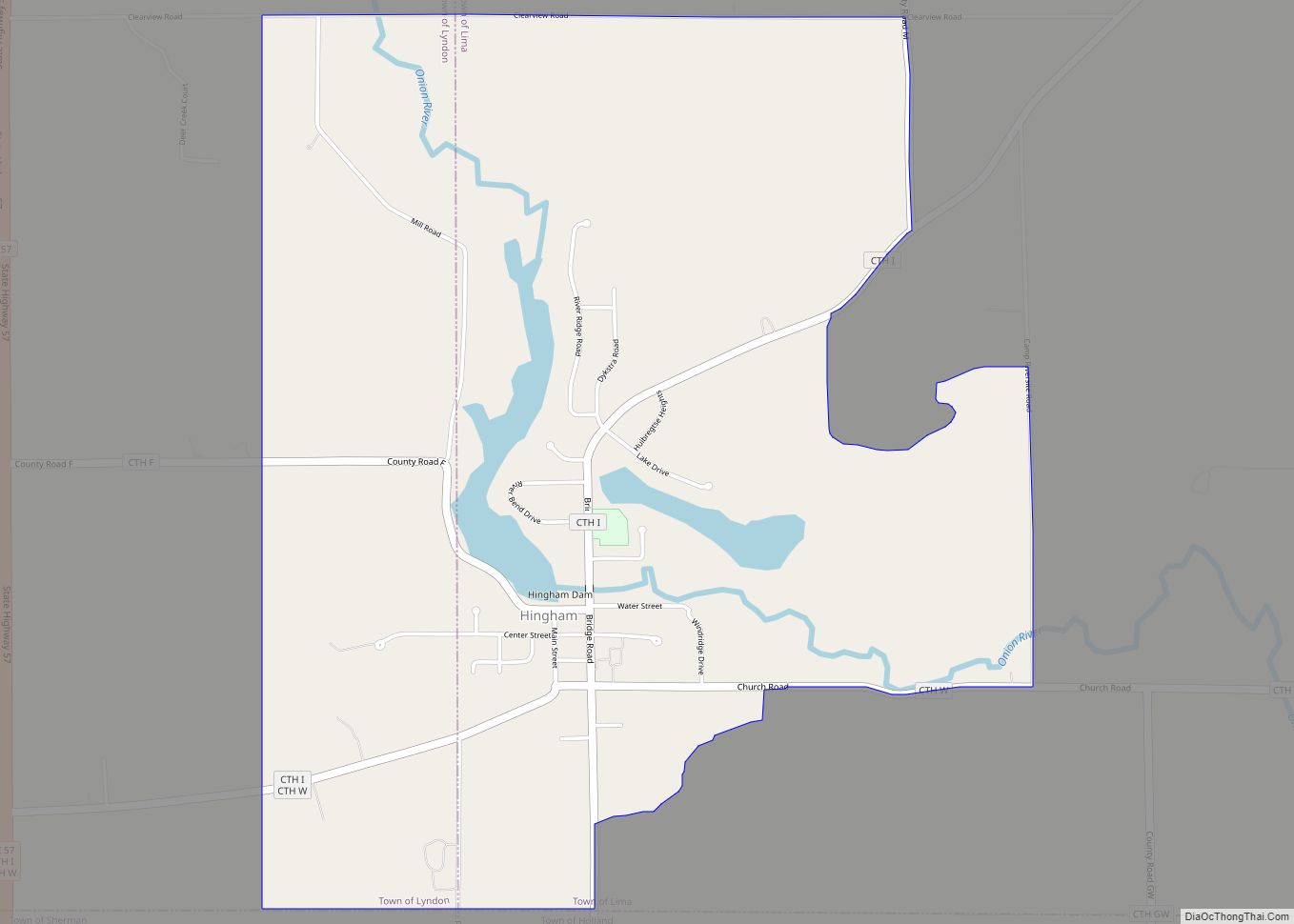
Map of Chippewa Falls city

Map of Chippewa Falls city

Chippewa Falls is a city located on the Chippewa River in Chippewa County in the northwestern part of the U.S. state of Wisconsin. The population was 14,778 in the 2021 census. Incorporated as a city in 1869, it is the county seat of Chippewa County. The city’s name originated from its location on the Chippewa … Read more

Map of Chilton city, Wisconsin

Map of Chilton city, Wisconsin

Chilton is a city in and county seat of Calumet County in the U.S. state of Wisconsin. The population was 4,080 at the 2020 census. The city is partially within the Town of Chilton. Chilton city overview: Name: Chilton city LSAD Code: 25 LSAD Description: city (suffix) State: Wisconsin County: Calumet County Elevation: 902 ft (275 m) … Read more

Map of Chili CDP, Wisconsin

Map of Chili CDP, Wisconsin

Chili is an unincorporated census-designated place in the Town of Fremont in Clark County, Wisconsin, United States. Chili is west-southwest of Marshfield. Chili has a post office with ZIP code 54420. As of the 2010 census, its population was 226. Chili CDP overview: Name: Chili CDP LSAD Code: 57 LSAD Description: CDP (suffix) State: Wisconsin … Read more

Map of Chief Lake CDP

Map of Chief Lake CDP

Chief Lake is a census-designated place (CDP) in the town of Hayward, Sawyer County, Wisconsin, United States. The population was 583 at the 2010 census. Chief Lake CDP overview: Name: Chief Lake CDP LSAD Code: 57 LSAD Description: CDP (suffix) State: Wisconsin County: Sawyer County Elevation: 1,339 ft (408 m) Total Area: 23.6 sq mi (61.2 km²) Land Area: 21.1 sq mi … Read more

Map of Chetek city

Map of Chetek city

Chetek is a city in Barron County, Wisconsin, United States. The population was 2,221 at the 2010 census. The city is located partially within the Town of Chetek. Chetek city overview: Name: Chetek city LSAD Code: 25 LSAD Description: city (suffix) State: Wisconsin County: Barron County Elevation: 1,050 ft (320 m) Total Area: 3.11 sq mi (8.05 km²) Land Area: … Read more

Map of Cuba City city

Map of Cuba City

Cuba City is a city partly in Grant County and partly in Lafayette County in the U.S. state of Wisconsin. The population was 2,086 at the 2010 census. Of this, 1,877 were in Grant County, and 209 were in Lafayette County. The city is nicknamed “The City of Presidents” because of the presidential banners displayed … Read more

Map of Coleman village, Wisconsin

Map of Coleman village, Wisconsin

Coleman is a village in Marinette County, Wisconsin, United States. The population was 724 at the 2010 census. It is part of the Marinette, WI–MI Micropolitan Statistical Area. Coleman village overview: Name: Coleman village LSAD Code: 47 LSAD Description: village (suffix) State: Wisconsin County: Marinette County Elevation: 712 ft (217 m) Total Area: 1.36 sq mi (3.53 km²) Land Area: … Read more

Map of Cross Plains village, Wisconsin

Map of Cross Plains village, Wisconsin

Cross Plains is a town in Dane County, Wisconsin, United States. The population was 1,419 at the 2000 census. The Village of Cross Plains is located partially within the town. The unincorporated community of Pine Bluff is located in the town. Cross Plains village overview: Name: Cross Plains village LSAD Code: 47 LSAD Description: village … Read more

Map of Colby city, Wisconsin

Map of Colby city, Wisconsin

Colby is a city in Clark and Marathon counties in the U.S. state of Wisconsin. It is part of the Wausau, Wisconsin Metropolitan Statistical Area. The population was 1,852 at the 2010 census. Of this, 1,354 were in Clark County, and 498 were in Marathon County. The city is bordered by the Town of Colby, … Read more

Map of Crivitz village

Map of Crivitz village

Crivitz is a village in Marinette County, Wisconsin, United States. The population was 984 at the 2010 census. It is part of the Marinette, WI–MI Micropolitan Statistical Area. Crivitz village overview: Name: Crivitz village LSAD Code: 47 LSAD Description: village (suffix) State: Wisconsin County: Marinette County Elevation: 679 ft (207 m) Total Area: 1.64 sq mi (4.25 km²) Land Area: … Read more

Map of Crandon city

Map of Crandon city

Crandon is a city in Forest County, Wisconsin, United States; it is in the northeastern part of the state, about 100 miles (160 km) north of Green Bay. The population was 1,713 at the 2020 census. It is the county seat of Forest County and is the only incorporated community in the county. The city is … Read more

Map of Couderay village

Map of Couderay village

Couderay is a town in Sawyer County, Wisconsin, United States. The population was 469 at the 2000 census. The village of Couderay, the census-designated place of Reserve, and the unincorporated community of Lemington are located within the town. The unincorporated community of Yarnell is located partially in the town. Couderay village overview: Name: Couderay village … Read more