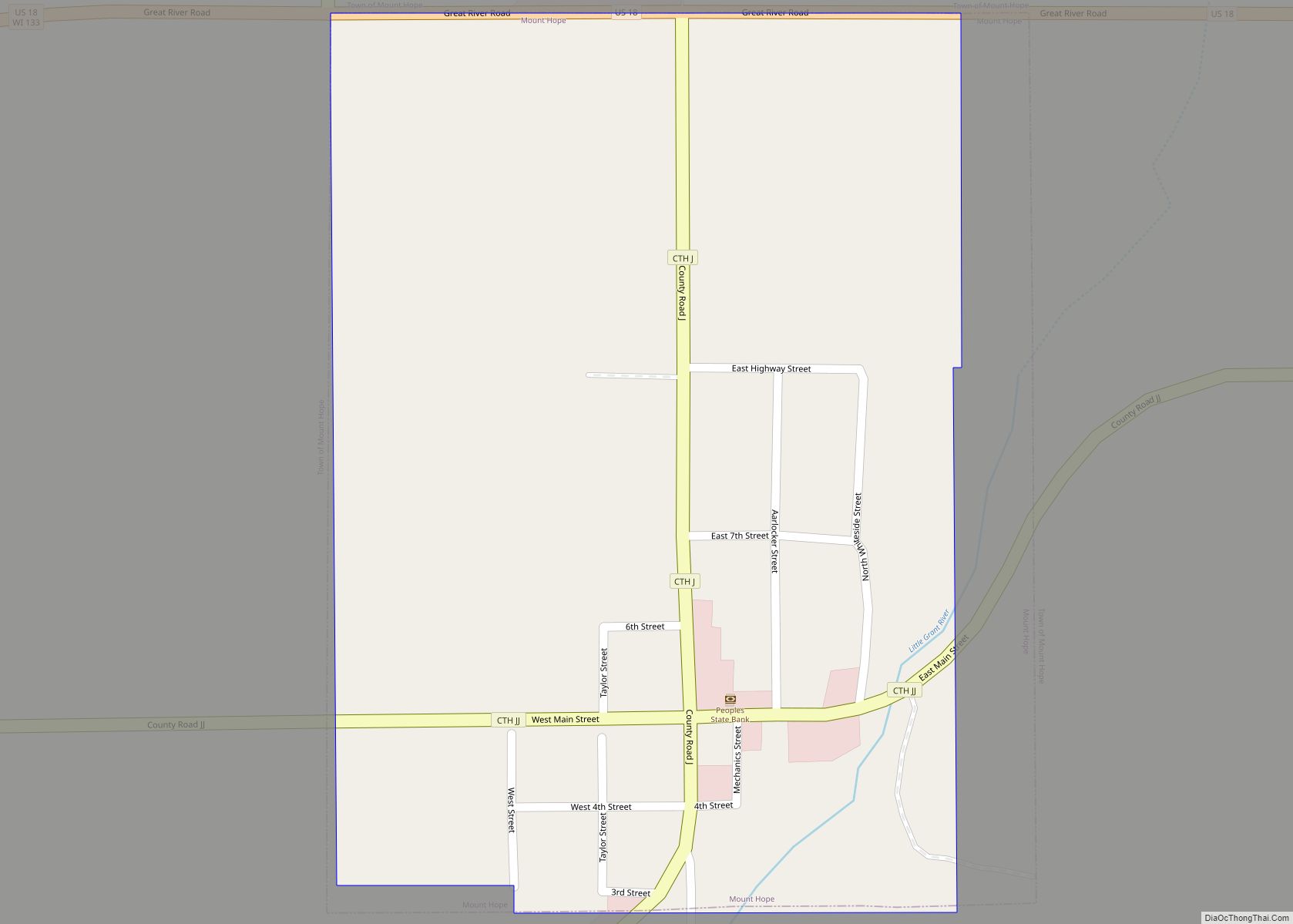
Map of Mountain CDP, Wisconsin
Mountain is an unincorporated census-designated place in Oconto County, Wisconsin, United States. The community is located at the intersection of Wisconsin Highway 32 and Wisconsin Highway 64, in the town of Mountain. It is located at latitude 45.185 and longitude -88.474 and elevation 971 feet (mean sea level). The postal code for Mountain is 54149. ... Read more
Map of Mountain CDP, Wisconsin
Map of Nichols village, Wisconsin
Nichols is a village in Outagamie County, Wisconsin, United States. The population was 273 at the 2010 census. Nichols village overview: Name: Nichols village LSAD Code: 47 LSAD Description: village (suffix) State: Wisconsin County: Outagamie County Elevation: 791 ft (241 m) Total Area: 0.89 sq mi (2.29 km²) Land Area: 0.89 sq mi (2.29 km²) Water Area: 0.00 sq mi (0.00 km²) Total Population: 273 Population ... Read more
Map of Nichols village, Wisconsin
Map of Niagara city, Wisconsin
Niagara is a city in Marinette County, Wisconsin, United States. The population was 1,624 at the 2010 census. The city lies to the north of and adjacent to the Town of Niagara. It is part of the Marinette, WI–MI Micropolitan Statistical Area. Niagara city overview: Name: Niagara city LSAD Code: 25 LSAD Description: city (suffix) ... Read more
Map of Niagara city, Wisconsin
Map of Newburg village, Wisconsin
Newburg is a village in Ozaukee and Washington Counties in the U.S. state of Wisconsin. The population was 1,254 at the 2010 census. Of this, 1,157 were in Washington County, and only 97 were in Ozaukee County. Newburg village overview: Name: Newburg village LSAD Code: 47 LSAD Description: village (suffix) State: Wisconsin County: Ozaukee County, ... Read more
Map of Newburg village, Wisconsin
Map of New Odanah CDP
New Odanah is a census-designated place in the town of Sanborn, Ashland County, Wisconsin, United States. Its population was 466 as of the 2020 census. New Odanah is located on the Bad River Indian Reservation. In local parlance, New Odanah is considered part of Odanah, which is the only name that appears on Wisconsin DOT ... Read more
Map of New Odanah CDP
Map of New London city, Wisconsin
New London is a city in Outagamie and Waupaca counties Wisconsin, United States. Founded in 1851, the population was 7,295 at the 2010 census. Of this, 5,685 were in Waupaca County, and 1,640 were in Outagamie County. The city has an annual Saint Patrick’s Day Parade, Irish Fest, and week-long festivities, when the city’s name ... Read more
Map of New London city, Wisconsin
Map of Oak Creek city, Wisconsin
Oak Creek is a city in the U.S. state of Wisconsin. Located in Milwaukee County, it sits on the southwestern shore of Lake Michigan and is located immediately south of Milwaukee. The city is one of the fastest growing in Milwaukee County and all of Wisconsin. As of the 2020 census, the population was 36,497. ... Read more
Map of Oak Creek city, Wisconsin
Map of New Lisbon city
New Lisbon is a city in Juneau County, Wisconsin, United States. The population was 1,748 at the 2020 census. New Lisbon city overview: Name: New Lisbon city LSAD Code: 25 LSAD Description: city (suffix) State: Wisconsin County: Juneau County Elevation: 896 ft (273 m) Total Area: 2.92 sq mi (7.57 km²) Land Area: 2.73 sq mi (7.08 km²) Water Area: 0.19 sq mi (0.49 km²) Total ... Read more
Map of New Lisbon city
Map of Norwalk village, Wisconsin
Norwalk is a village in Monroe County, Wisconsin, United States. The population was 638 at the 2010 census. Norwalk village overview: Name: Norwalk village LSAD Code: 47 LSAD Description: village (suffix) State: Wisconsin County: Monroe County Elevation: 1,017 ft (310 m) Total Area: 1.03 sq mi (2.67 km²) Land Area: 1.03 sq mi (2.67 km²) Water Area: 0.00 sq mi (0.00 km²) Total Population: 638 Population ... Read more
Map of Norwalk village, Wisconsin
Map of New Holstein city
New Holstein is a city in Calumet County in the U.S. state of Wisconsin. The population was 3,236 at the 2010 census. The city is located within the Town of New Holstein. New Holstein city overview: Name: New Holstein city LSAD Code: 25 LSAD Description: city (suffix) State: Wisconsin County: Calumet County Elevation: 932 ft (284 m) ... Read more
Map of New Holstein city
Map of Northport CDP, Wisconsin
Northport is an unincorporated census-designated place located in the town of Mukwa, in Waupaca County, Wisconsin, United States. The community is on Wisconsin Highway 54, approximately two miles northwest from New London. As of the 2010 census, its population is 491. Northport CDP overview: Name: Northport CDP LSAD Code: 57 LSAD Description: CDP (suffix) State: ... Read more
Map of Northport CDP, Wisconsin
Map of New Glarus village
New Glarus is a village in Green County, Wisconsin, United States at the intersection of Wisconsin Highways 69 and 39. It has a population of 2,266 according to the 2020 census. The village, and the town that surrounds it, were named after the canton of Glarus in eastern Switzerland. The community was founded in 1845 ... Read more
Map of New Glarus village