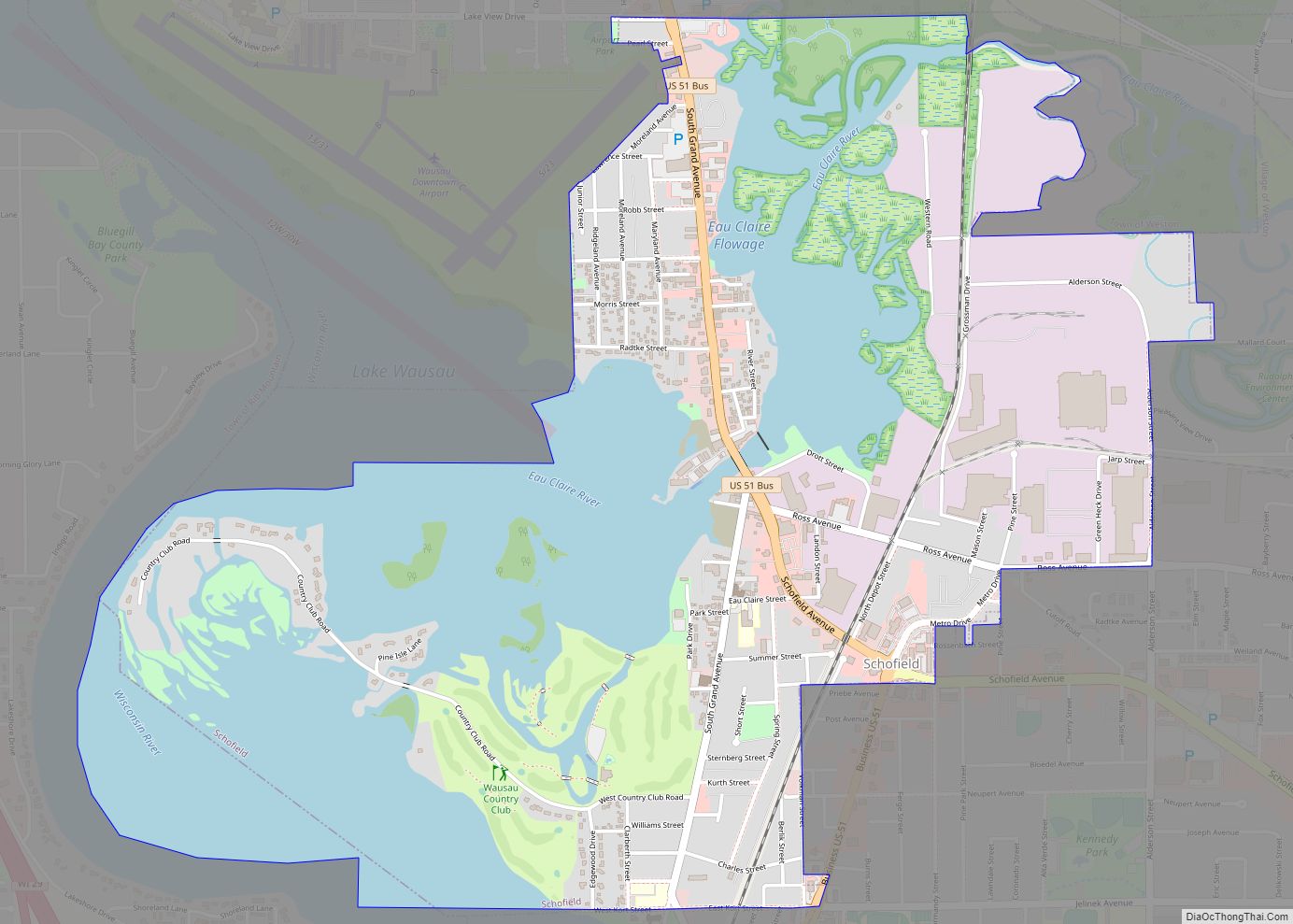
Map of Lake Wisconsin CDP

Map of Lake Wisconsin CDP

Lake Wisconsin is a census-designated place (CDP) in Columbia and Sauk counties, in the towns of Lodi and Merrimac, in Wisconsin, United States. The population was 4,189 at the 2010 census. The Columbia County portion of the Lake Wisconsin is part of the Madison Metropolitan Statistical Area, while the Sauk County portion is part of … Read more

Map of Lake Wazeecha CDP

Map of Lake Wazeecha CDP

Lake Wazeecha is a census-designated place (CDP) in the town of Grand Rapids, Wood County, Wisconsin, United States. The population was 2,651 at the 2010 census. Lake Wazeecha CDP overview: Name: Lake Wazeecha CDP LSAD Code: 57 LSAD Description: CDP (suffix) State: Wisconsin County: Wood County Elevation: 1,033 ft (315 m) Total Area: 3.9 sq mi (10.2 km²) Land Area: … Read more

Map of Lake Tomahawk CDP, Wisconsin

Map of Lake Tomahawk CDP, Wisconsin

Lake Tomahawk is an unincorporated census-designated place located in the town of Lake Tomahawk, Oneida County, Wisconsin, United States. Lake Tomahawk is located on Wisconsin Highway 47 15 miles (24 km) northwest of Rhinelander. Lake Tomahawk has a post office with ZIP code 54539. As of the 2010 census, its population was 228. Lake Tomahawk CDP … Read more

Map of Lake Sherwood CDP, Wisconsin

Map of Lake Sherwood CDP, Wisconsin

Lake Sherwood is a census-designated place in the town of Rome, Adams County, Wisconsin, United States. Its population was 372 as of the 2010 census. Lake Sherwood CDP overview: Name: Lake Sherwood CDP LSAD Code: 57 LSAD Description: CDP (suffix) State: Wisconsin County: Adams County Elevation: 1,014 ft (309 m) Total Area: 1.404 sq mi (3.64 km²) Land Area: 1.054 sq mi … Read more

Map of Lake Ripley CDP

Map of Lake Ripley CDP

Lake Ripley is a census-designated place (CDP), in the town of Oakland, Jefferson County, Wisconsin, United States. The population was 1,911 at the 2020 census. Lake Ripley CDP overview: Name: Lake Ripley CDP LSAD Code: 57 LSAD Description: CDP (suffix) State: Wisconsin County: Jefferson County Elevation: 853 ft (260 m) Total Area: 2.6 sq mi (6.7 km²) Land Area: 1.9 sq mi … Read more

Map of Lewis CDP, Wisconsin

Map of Lewis CDP, Wisconsin

Lewis is an unincorporated census-designated place in the town of Clam Falls, Polk County, Wisconsin, United States. Lewis is located on Wisconsin Highway 35 4.5 miles (7.2 km) northeast of Frederic. As of the 2010 census, its population is 164. Lewis CDP overview: Name: Lewis CDP LSAD Code: 57 LSAD Description: CDP (suffix) State: Wisconsin County: … Read more

Map of Leopolis CDP

Map of Leopolis CDP

Leopolis is an unincorporated census-designated place in Shawano County, Wisconsin, United States. The community is located on County Highway D, between the towns of Herman, and Pella, Wisconsin. As of the 2010 census, its population is 87. Leopolis CDP overview: Name: Leopolis CDP LSAD Code: 57 LSAD Description: CDP (suffix) State: Wisconsin County: Shawano County … Read more

Map of Lena village, Wisconsin

Map of Lena village, Wisconsin

Lena is a town in Oconto County, Wisconsin, United States. The population was 769 at the 2000 census. The Village of Lena is adjacent to the town. Lena village overview: Name: Lena village LSAD Code: 47 LSAD Description: village (suffix) State: Wisconsin County: Oconto County FIPS code: 5543325 Online Interactive Map Lena online map. Source: … Read more

Map of Long Lake CDP, Wisconsin

Map of Long Lake CDP, Wisconsin

Long Lake is an unincorporated census-designated place in the town of Long Lake, Florence County, Wisconsin, United States. Long Lake is located on the eastern shore of Long Lake along Wisconsin Highway 139, 21 miles (34 km) west-southwest of Florence. As of the 2020 census, its population was 59. The community became a census-designated place in … Read more

Map of Legend Lake CDP

Map of Legend Lake CDP

Legend Lake is a census-designated place (CDP) in Menominee County, Wisconsin, Wisconsin, United States, on the Menominee Indian Reservation. The population was 1,670 at the 2020 census. Legend Lake CDP overview: Name: Legend Lake CDP LSAD Code: 57 LSAD Description: CDP (suffix) State: Wisconsin County: Menominee County Elevation: 458 ft (140 m) Total Area: 20.5 sq mi (53.1 km²) Land … Read more

Map of Lone Rock village, Wisconsin

Map of Lone Rock village, Wisconsin

Lone Rock is a village in Richland County, Wisconsin, United States. The population was 888 at the 2010 census. The village is named after a sandstone outcrop. Lone Rock village overview: Name: Lone Rock village LSAD Code: 47 LSAD Description: village (suffix) State: Wisconsin County: Richland County Elevation: 709 ft (216 m) Total Area: 1.00 sq mi (2.58 km²) Land … Read more

Map of Lebanon CDP, Wisconsin

Map of Lebanon CDP, Wisconsin

Lebanon is an unincorporated census-designated place located in the town of Lebanon, Dodge County, Wisconsin, United States. Lebanon is 6.5 miles (10.5 km) northeast of Watertown. Lebanon has a post office with ZIP code 53047. As of the 2010 census, its population was 204. Lebanon CDP overview: Name: Lebanon CDP LSAD Code: 57 LSAD Description: CDP … Read more