Map of Vesper village
Vesper is a village in Wood County, Wisconsin, United States. The population was 584 at the 2010 census. Vesper village overview: Name: Vesper village LSAD Code: 47 LSAD Description: village (suffix) State: Wisconsin County: Wood County Elevation: 1,096 ft (334 m) Total Area: 1.16 sq mi (2.99 km²) Land Area: 1.16 sq mi (2.99 km²) Water Area: 0.00 sq mi (0.00 km²) Total Population: 584 Population ... Read more
Map of Vesper village
Map of Van Dyne CDP
Van Dyne is an unincorporated community and census-designated place in the town of Friendship, in Fond du Lac County, Wisconsin, United States. At the 2020 census, its population was 292. The road traveling north-south through the community was part of the Yellowstone Trail and later Wisconsin Highway 175; it is now a county highway. Van ... Read more
Map of Van Dyne CDP
Map of Valders village
Valders is a village in Manitowoc County, Wisconsin, United States. The population was 962 at the 2010 census. Valders village overview: Name: Valders village LSAD Code: 47 LSAD Description: village (suffix) State: Wisconsin County: Manitowoc County Elevation: 833 ft (254 m) Total Area: 1.44 sq mi (3.73 km²) Land Area: 1.44 sq mi (3.73 km²) Water Area: 0.00 sq mi (0.01 km²) Total Population: 962 Population ... Read more
Map of Valders village
Map of Unity village, Wisconsin
Unity is a village in Clark and Marathon counties in the U.S. state of Wisconsin. It is part of the Wausau, Wisconsin Metropolitan Statistical Area. The population was 343 at the 2010 census. Of this, 204 were in Marathon County, and 139 were in Clark County. The village is located in northeastern town of Unity ... Read more
Map of Unity village, Wisconsin
Map of Union Grove village, Wisconsin
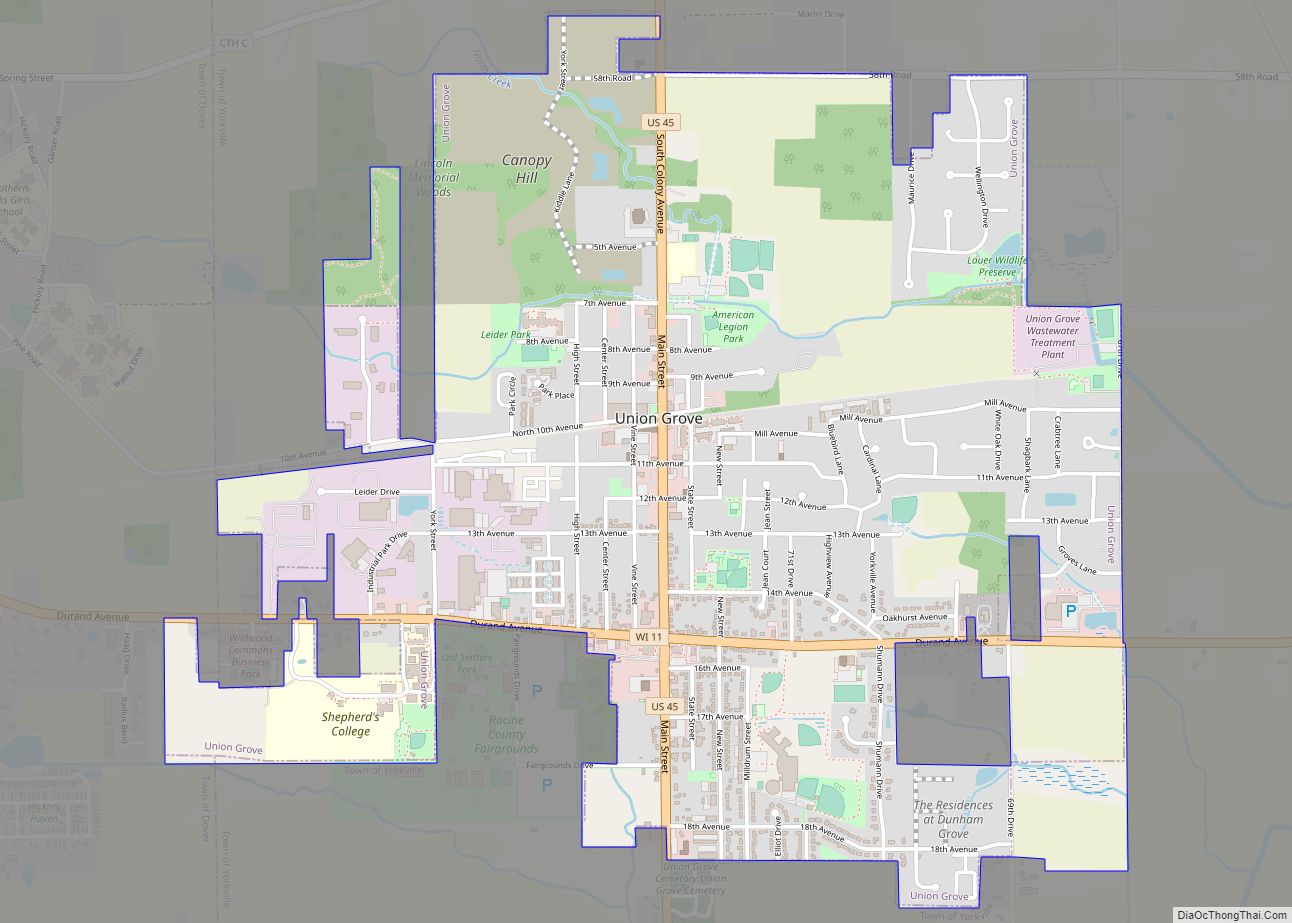
Union Grove is a village in Racine County, Wisconsin, United States. The population was 4,806 at the 2020 census. Union Grove village overview: Name: Union Grove village LSAD Code: 47 LSAD Description: village (suffix) State: Wisconsin County: Racine County Elevation: 774 ft (236 m) Total Area: 2.60 sq mi (6.72 km²) Land Area: 2.60 sq mi (6.72 km²) Water Area: 0.00 sq mi (0.00 km²) Total ... Read more
Map of Union Grove village, Wisconsin
Map of Union Center village
Union Center is a village in Juneau County, Wisconsin, United States, along the Baraboo River. The population was 200 at the 2010 census. Union Center village overview: Name: Union Center village LSAD Code: 47 LSAD Description: village (suffix) State: Wisconsin County: Juneau County Elevation: 925 ft (282 m) Total Area: 0.82 sq mi (2.14 km²) Land Area: 0.82 sq mi (2.14 km²) Water ... Read more
Map of Union Center village
Map of Two Rivers city, Wisconsin
Two Rivers is a city in Manitowoc County, Wisconsin, United States. The population was 11,712 at the 2010 census. It is the birthplace of the ice cream sundae (though other cities, such as Ithaca, New York, make the same claim). The city’s advertising slogan is “Catch our friendly waves” as it is located along Lake ... Read more
Map of Two Rivers city, Wisconsin
Map of Twin Lakes village, Wisconsin
Twin Lakes is a village in Kenosha County, Wisconsin, United States, along the Illinois–Wisconsin border east of U.S. Highway 12, incorporated in 1937. With nearly 1000 acres of surface water, the twin lakes of Mary and Elizabeth have drawn vacationers to numerous resorts as well as ice harvesters in the days of icebox refrigeration. Today, ... Read more
Map of Twin Lakes village, Wisconsin
Map of Turtle Lake CDP, Wisconsin
Turtle Lake is a census-designated place in the town of Richmond, Walworth County, Wisconsin, United States. Its population was 348 as of the 2020 census. Turtle Lake is 141 acres and has a maximum depth of 30 feet. Visitors have access to the lake from a public boat landing. Fish include panfish, largemouth bass, and ... Read more
Map of Turtle Lake CDP, Wisconsin
Map of Wausaukee village
Wausaukee is a town in Marinette County, Wisconsin, United States. The estimated population was 573 in 2011. The Village of Wausaukee is located within the town. The unincorporated community of Cedarville is located partially in the town. Wausaukee village overview: Name: Wausaukee village LSAD Code: 47 LSAD Description: village (suffix) State: Wisconsin County: Marinette County ... Read more
Map of Wausaukee village
Map of Wausau city, Wisconsin
Wausau (/ˈwɔːsɔː/ WAW-saw) is a city in and the county seat of Marathon County, Wisconsin, United States. The Wisconsin River divides the city into east and west. The city’s suburbs include Schofield, Weston, Mosinee, Maine, Rib Mountain, Kronenwetter, and Rothschild. As of the 2020 census, Wausau had a population of 39,994. It is the core ... Read more
Map of Wausau city, Wisconsin
Map of Waupun city
Waupun is a city in Dodge and Fond du Lac counties in the U.S. state of Wisconsin. The population was 11,344 at the 2020 census. Of this, 7,795 were in Dodge County, and 3,549 were in Fond du Lac County. In Fond du Lac County, the Town of Waupun abuts the city of Waupun. Waupun ... Read more
Map of Waupun city