Map of Almena village, Wisconsin
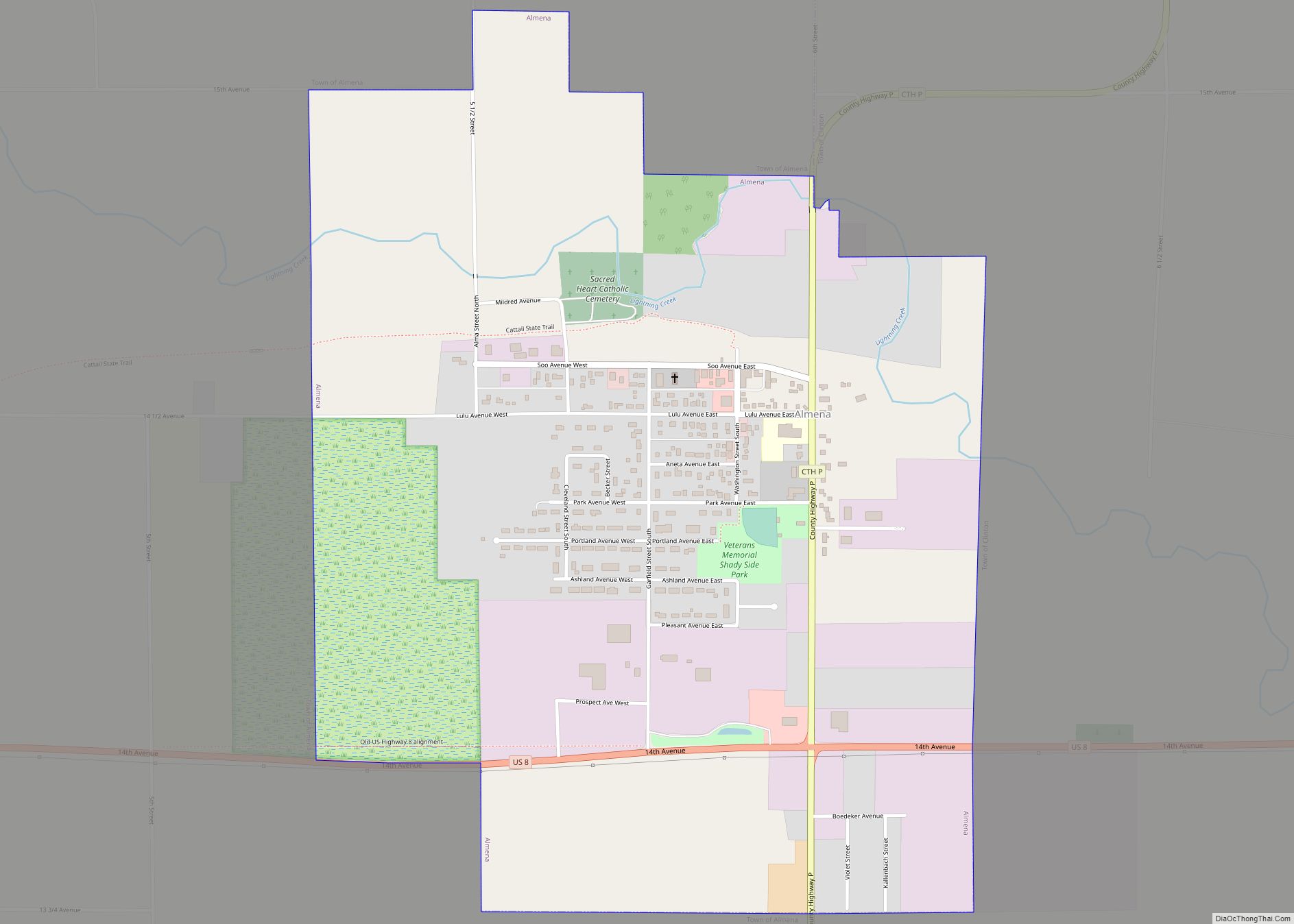
The Town of Almena is in Barron County in the U.S. state of Wisconsin. The population was 858 at the 2010 census. The Village of Almena is partially located within the town. Almena village overview: Name: Almena village LSAD Code: 47 LSAD Description: village (suffix) State: Wisconsin County: Barron County FIPS code: 5501325 Online Interactive ... Read more
Map of Almena village, Wisconsin
Map of Alma city, Wisconsin
Alma is a city in and the county seat of Buffalo County, Wisconsin, United States. The population was 716 at the 2020 census. The motto for the city of Alma is: “Step into Living History.” Alma city overview: Name: Alma city LSAD Code: 25 LSAD Description: city (suffix) State: Wisconsin County: Buffalo County Elevation: 673 ft ... Read more
Map of Alma city, Wisconsin
Map of Allouez village
Allouez is a village in Brown County in the U.S. state of Wisconsin. The population was 13,975 at the 2010 census. It is part of the Green Bay Metropolitan Statistical Area. Allouez village overview: Name: Allouez village LSAD Code: 47 LSAD Description: village (suffix) State: Wisconsin County: Brown County Elevation: 597 ft (182 m) Total Area: 5.21 sq mi ... Read more
Map of Allouez village
Map of Arcadia city, Wisconsin
Arcadia is a city in Trempealeau County, Wisconsin, United States, along the Trempealeau River. The population was 3,737 at the 2020 census. Arcadia is a Latino-majority city and the largest city in Trempealeau county. Arcadia city overview: Name: Arcadia city LSAD Code: 25 LSAD Description: city (suffix) State: Wisconsin County: Trempealeau County Total Area: 3.27 sq mi ... Read more
Map of Arcadia city, Wisconsin
Map of Appleton city, Wisconsin
Appleton (Menominee: Ahkōnemeh) is a city in Outagamie, Calumet, and Winnebago counties in the U.S. state of Wisconsin. One of the Fox Cities, it is situated on the Fox River, 30 miles (48 km) southwest of Green Bay and 100 miles (160 km) north of Milwaukee. Appleton is the county seat of Outagamie County. As of the ... Read more
Map of Appleton city, Wisconsin
Map of Albany village, Wisconsin
Albany is a village in Green County, Wisconsin, United States. The population was 1,018 at the 2010 census. The village is located within the Town of Albany. Albany village overview: Name: Albany village LSAD Code: 47 LSAD Description: village (suffix) State: Wisconsin County: Green County Total Area: 1.29 sq mi (3.35 km²) Land Area: 1.27 sq mi (3.29 km²) Water Area: ... Read more
Map of Albany village, Wisconsin
Map of Antigo city
Antigo (/ˈæntɪˌɡoʊ/ AN-ti-goh) is a city in and the county seat of Langlade County, Wisconsin, United States. The population was 8,100 at the 2020 census. Antigo is the center of a farming and lumbering district, and its manufactures consist principally of lumber, chairs, furniture, sashes, doors and blinds, hubs and spokes, and other wood products. ... Read more
Map of Antigo city
Map of Aniwa village
Aniwa is a town in Shawano County, Wisconsin, United States. The population was 586 at the 2000 census. The Village of Aniwa is located within the town. Aniwa village overview: Name: Aniwa village LSAD Code: 47 LSAD Description: village (suffix) State: Wisconsin County: Shawano County FIPS code: 5502075 Online Interactive Map Aniwa online map. Source: ... Read more
Map of Aniwa village
Map of Angelica CDP, Wisconsin
Angelica is a census-designated place in the towns of Angelica and Maple Grove in Shawano County, Wisconsin, United States. Its population was 92 as of the 2010 census. Angelica CDP overview: Name: Angelica CDP LSAD Code: 57 LSAD Description: CDP (suffix) State: Wisconsin County: Shawano County Elevation: 879 ft (268 m) Total Area: 1.56 sq mi (4.05 km²) Land Area: ... Read more
Map of Angelica CDP, Wisconsin
Map of Bancroft CDP, Wisconsin
Bancroft is an unincorporated census-designated place in Portage County, Wisconsin, United States. As of the 2010 census, its population is 535. It is included in the Stevens Point, Wisconsin Micropolitan Statistical Area. Bancroft CDP overview: Name: Bancroft CDP LSAD Code: 57 LSAD Description: CDP (suffix) State: Wisconsin County: Portage County Elevation: 1,093 ft (333 m) Total Area: ... Read more
Map of Bancroft CDP, Wisconsin
Map of Arkansaw CDP
Arkansaw is an unincorporated census-designated place in the eastern portion of the town of Waterville, in Pepin County, Wisconsin, United States. Located approximately 3 miles (4.8 km) west of Durand, it has the ZIP code of 54721. As of the 2010 census, its population was 177. From 1881 to 1886, the community was the county seat ... Read more
Map of Arkansaw CDP
Map of Baldwin village, Wisconsin
Baldwin is a town in St. Croix County, Wisconsin, United States. The population was 903 at the 2000 census. The Village of Baldwin is located partially within the town. The unincorporated community of Dahl is also located in the town. Baldwin village overview: Name: Baldwin village LSAD Code: 47 LSAD Description: village (suffix) State: Wisconsin ... Read more
Map of Baldwin village, Wisconsin