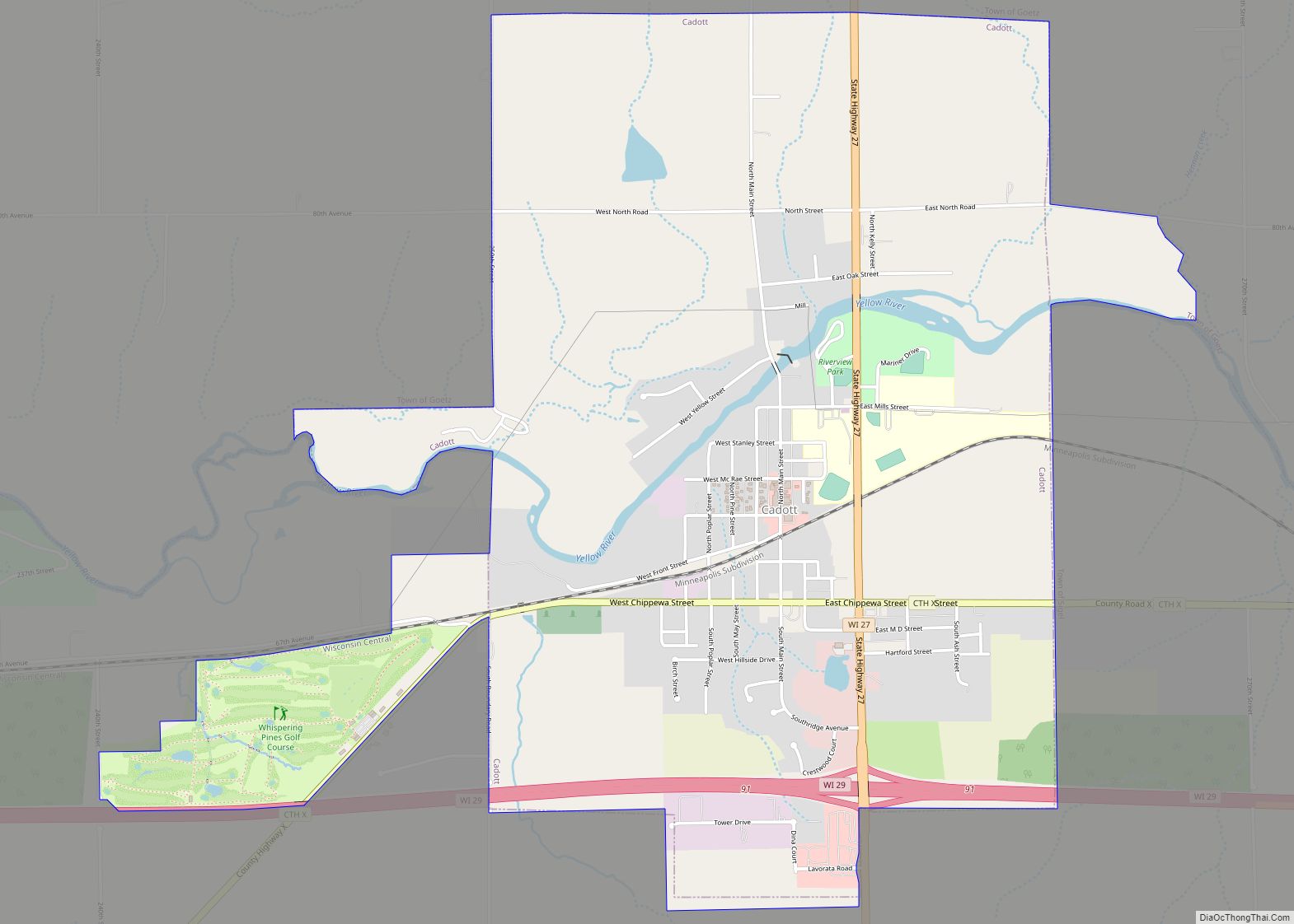
Map of Pulcifer CDP

Map of Pulcifer CDP

Pulcifer is an unincorporated census-designated place in the town of Green Valley, Shawano County, Wisconsin, United States. Pulcifer is located on the Oconto River and Wisconsin Highway 22 5 miles (8.0 km) northeast of Cecil. As of the 2010 census, its population is 134. Pulcifer CDP overview: Name: Pulcifer CDP LSAD Code: 57 LSAD Description: CDP … Read more

Map of Rothschild village

Map of Rothschild village

Rothschild is a village in Marathon County, Wisconsin, United States. It is part of the Wausau, Wisconsin Metropolitan Statistical Area. The population was 5,567 at the 2020 census. Rothschild is the northern terminus of Interstate 39, which starts in Normal, Illinois. Rothschild village overview: Name: Rothschild village LSAD Code: 47 LSAD Description: village (suffix) State: … Read more

Map of Richfield village, Wisconsin

Map of Richfield village, Wisconsin

Richfield is a village in Washington County, Wisconsin, United States. The population was 11,739 at the 2020 census. The previously unincorporated communities of Hubertus and Pleasant Hill are located in the village, as well as the communities of Colgate and Lake Five, which are partially located in Richfield. Richfield village overview: Name: Richfield village LSAD … Read more

Map of Rosholt village, Wisconsin

Map of Rosholt village, Wisconsin

Rosholt is a village in Portage County, Wisconsin, United States. The population was 478 at the 2020 census. Rosholt village overview: Name: Rosholt village LSAD Code: 47 LSAD Description: village (suffix) State: Wisconsin County: Portage County Elevation: 1,138 ft (347 m) Total Area: 1.09 sq mi (2.81 km²) Land Area: 1.05 sq mi (2.72 km²) Water Area: 0.04 sq mi (0.09 km²) Total Population: 478 Population … Read more

Map of Rice Lake city, Wisconsin

Map of Rice Lake city, Wisconsin

Rice Lake is a city in Barron County, Wisconsin, United States. As of the 2020 census, the city had a total population of 9,040. The city is located mostly within the Town of Rice Lake. Rice Lake city overview: Name: Rice Lake city LSAD Code: 25 LSAD Description: city (suffix) State: Wisconsin County: Barron County … Read more

Map of Rosendale village, Wisconsin

Map of Rosendale village, Wisconsin

Rosendale is a town in Fond du Lac County, Wisconsin, United States. The population was 783 at the 2000 census. The village of Rosendale is located partially within the town. The unincorporated communities of Rosendale Center and West Rosendale are also located in the town. Rosendale village overview: Name: Rosendale village LSAD Code: 47 LSAD … Read more

Map of Rib Mountain CDP

Map of Rib Mountain CDP

Rib Mountain is a census-designated place (CDP) in the town of Rib Mountain in Marathon County, Wisconsin, United States. The population was 6,061 at the 2020 census. The community is named for Rib Mountain. Rib Mountain CDP overview: Name: Rib Mountain CDP LSAD Code: 57 LSAD Description: CDP (suffix) State: Wisconsin County: Marathon County Total … Read more

Map of Rome CDP, Wisconsin

Map of Rome CDP, Wisconsin

Rome is a census-designated place (CDP) in the town of Sullivan in Jefferson County, Wisconsin, United States, along the Bark River. The population was 752 at the 2020 census. Rome CDP overview: Name: Rome CDP LSAD Code: 57 LSAD Description: CDP (suffix) State: Wisconsin County: Jefferson County Elevation: 840 ft (260 m) Total Area: 3.945 sq mi (10.22 km²) Land … Read more

Map of Rockland village, Wisconsin

Map of Rockland village, Wisconsin

Rockland is a village in eastern La Crosse County, Wisconsin, United States, along the La Crosse River. It is part of the La Crosse, Wisconsin Metropolitan Statistical Area. The population was 765 at the 2020 census. Rockland village overview: Name: Rockland village LSAD Code: 47 LSAD Description: village (suffix) State: Wisconsin County: La Crosse County … Read more

Map of Rockdale village, Wisconsin

Map of Rockdale village, Wisconsin

Rockdale is a village in Dane County, Wisconsin, United States. The population was 207 at the 2020 census. The village is split in half by the Koshkonong Creek. It is part of the Madison Metropolitan Statistical Area. Rockdale village overview: Name: Rockdale village LSAD Code: 47 LSAD Description: village (suffix) State: Wisconsin County: Dane County … Read more

Map of Rock Springs village, Wisconsin

Map of Rock Springs village, Wisconsin

Rock Springs is a village in Sauk County, Wisconsin, United States, along the Baraboo River. The population was 362 at the 2010 census. Rock Springs village overview: Name: Rock Springs village LSAD Code: 47 LSAD Description: village (suffix) State: Wisconsin County: Sauk County Elevation: 974 ft (297 m) Total Area: 1.33 sq mi (3.45 km²) Land Area: 1.30 sq mi (3.37 km²) Water … Read more

Map of Rochester village, Wisconsin

Map of Rochester village, Wisconsin

Rochester is a village in Racine County, Wisconsin, United States. The population was 3,785 at the 2020 census. The village is located within the former Town of Rochester. On November 4, 2008, the village of Rochester voted to consolidate with the Town of Rochester. Rochester village overview: Name: Rochester village LSAD Code: 47 LSAD Description: … Read more