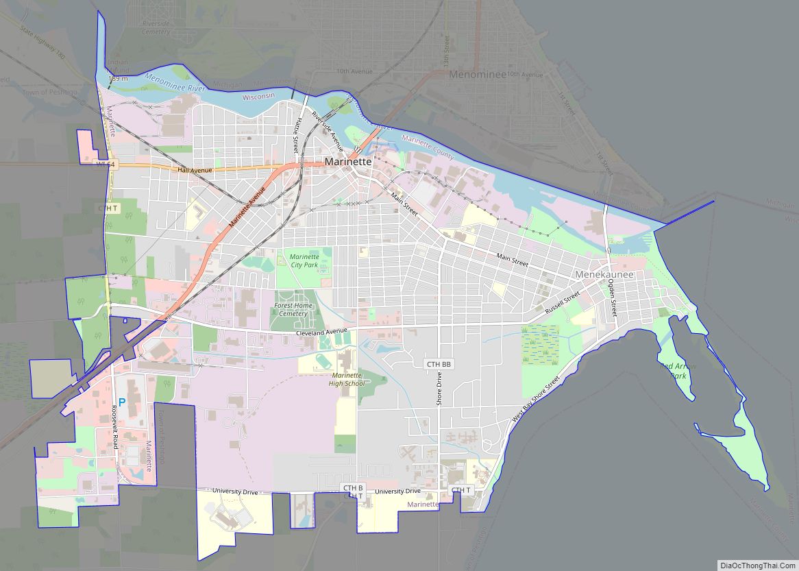
Map of Tustin CDP, Wisconsin

Map of Tustin CDP, Wisconsin

Tustin is a census-designated place in the Town of Bloomfield, Waushara County, Wisconsin, United States. Its population was 117 as of the 2010 census. Tustin is located on the northern shore of Lake Poygan. Tustin CDP overview: Name: Tustin CDP LSAD Code: 57 LSAD Description: CDP (suffix) State: Wisconsin County: Waushara County Elevation: 751 ft (229 m) … Read more

Map of Wauwatosa city

Map of Wauwatosa city

Wauwatosa (/ˌwɔːwəˈtoʊsə/; known informally as Tosa; originally Wau-wau-too-sa or Hart’s Mill) is a city in Milwaukee County, Wisconsin, United States. The population was 48,387 at the 2020 census. Wauwatosa is located immediately west of Milwaukee, and is a part of the Milwaukee metropolitan area. It is named after the Potawatomi Chief Wauwataesie and the Potawatomi … Read more

Map of Walworth village

Map of Walworth village

Walworth is a town in Walworth County, Wisconsin, United States. The population was 1,565 at the 2020 census. The Village of Walworth is located within the town. The unincorporated communities of Big Foot Prairie and Delavan Lake are also located partially in the town. Walworth village overview: Name: Walworth village LSAD Code: 47 LSAD Description: … Read more

Map of Wautoma city

Map of Wautoma city

Wautoma is a city in Waushara County, Wisconsin, United States. The population was 2,218 at the 2010 census. Wautoma is the county seat of Waushara County. The city consists of three noncontiguous areas: one is entirely within the Town of Wautoma, the second is entirely within the Town of Dakota, and the third straddles the … Read more

Map of Wales village, Wisconsin

Map of Wales village, Wisconsin

Wales is a village in Waukesha County, Wisconsin, first settled by Welsh immigrants. The population was 2,862 at the time of the 2020 census. Wales village overview: Name: Wales village LSAD Code: 47 LSAD Description: village (suffix) State: Wisconsin County: Waukesha County Elevation: 1,001 ft (305 m) Total Area: 3.23 sq mi (8.37 km²) Land Area: 3.23 sq mi (8.36 km²) Water Area: … Read more

Map of Wausaukee village

Map of Wausaukee village

Wausaukee is a town in Marinette County, Wisconsin, United States. The estimated population was 573 in 2011. The Village of Wausaukee is located within the town. The unincorporated community of Cedarville is located partially in the town. Wausaukee village overview: Name: Wausaukee village LSAD Code: 47 LSAD Description: village (suffix) State: Wisconsin County: Marinette County … Read more

Map of Wausau city, Wisconsin

Map of Wausau city, Wisconsin

Wausau (/ˈwɔːsɔː/ WAW-saw) is a city in and the county seat of Marathon County, Wisconsin, United States. The Wisconsin River divides the city into east and west. The city’s suburbs include Schofield, Weston, Mosinee, Maine, Rib Mountain, Kronenwetter, and Rothschild. As of the 2020 census, Wausau had a population of 39,994. It is the core … Read more

Map of Waupun city

Map of Waupun city

Waupun is a city in Dodge and Fond du Lac counties in the U.S. state of Wisconsin. The population was 11,344 at the 2020 census. Of this, 7,795 were in Dodge County, and 3,549 were in Fond du Lac County. In Fond du Lac County, the Town of Waupun abuts the city of Waupun. Waupun … Read more

Map of Waupaca city

Map of Waupaca city

Waupaca is a city in and the county seat of Waupaca County in the U.S. state of Wisconsin. The population was 6,282 at the 2020 census. The city is located mostly within the Town of Waupaca, and it is politically independent of the town. A portion extends west into the adjacent Town of Farmington, and … Read more

Map of Waunakee village

Map of Waunakee village

Waunakee (/ˌwɔːnəˈkiː/) is a village in Dane County, Wisconsin, United States. The population was 14,879 at the 2020 census. It is part of the Madison Metropolitan Statistical Area. Waunakee bills itself as “The Only Waunakee in the World”. Waunakee village overview: Name: Waunakee village LSAD Code: 47 LSAD Description: village (suffix) State: Wisconsin County: Dane … Read more

Map of Waumandee CDP

Map of Waumandee CDP

Waumandee is an unincorporated census-designated place located in the town of Waumandee, in Buffalo County, Wisconsin, United States. Waumandee is located on County Highway U 8.5 miles (13.7 km) northeast of Cochrane. As of the 2010 census, its population is 68. Waumandee CDP overview: Name: Waumandee CDP LSAD Code: 57 LSAD Description: CDP (suffix) State: Wisconsin … Read more

Map of Waukesha city

Map of Waukesha city

Waukesha (/ˈwɔːkɪʃɔː/ WAW-ki-shaw) is the county seat of Waukesha County, Wisconsin, United States. It is part of the Milwaukee metropolitan area. Its population was 70,980 at the 2020 census. The city is adjacent to the Village of Waukesha. Waukesha city overview: Name: Waukesha city LSAD Code: 25 LSAD Description: city (suffix) State: Wisconsin County: Waukesha … Read more