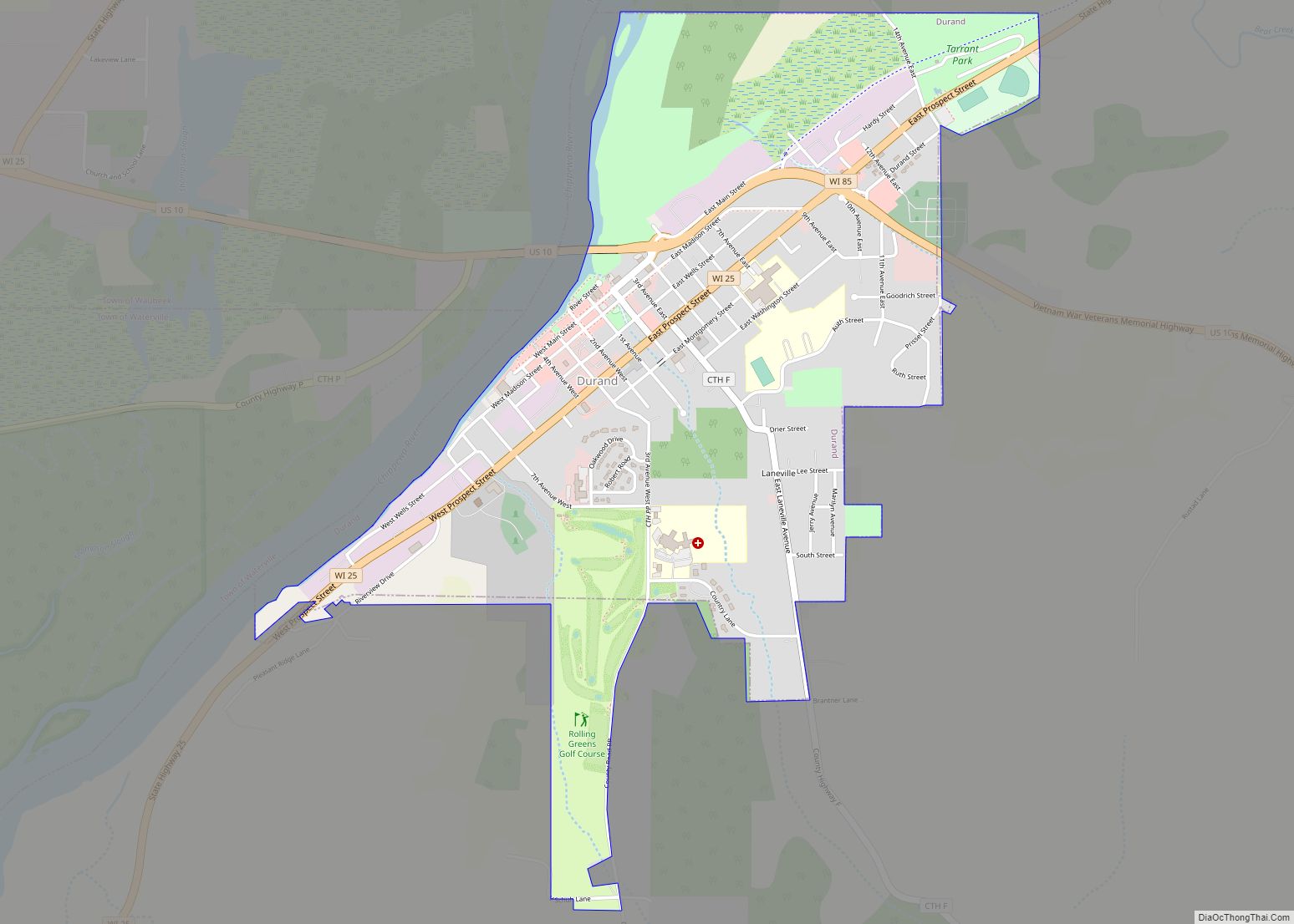
Map of Black Earth village

Map of Black Earth village

The Town of Black Earth is located in Dane County, Wisconsin, United States. The population was 510 at the 2020 census. Black Earth village overview: Name: Black Earth village LSAD Code: 47 LSAD Description: village (suffix) State: Wisconsin County: Dane County FIPS code: 5507800 Online Interactive Map Black Earth online map. Source: Basemap layers from … Read more

Map of Black Creek village, Wisconsin

Map of Black Creek village, Wisconsin

Black Creek is a town in Outagamie County, Wisconsin, United States. The population was 1,251 at the 2020 census. The Village of Black Creek (governed separately) and the unincorporated community of Binghamton are located in the town. The unincorporated community of Five Corners is also located partially in the town. Black Creek village overview: Name: … Read more

Map of Boulder Junction CDP

Map of Boulder Junction CDP

Boulder Junction is an unincorporated census-designated place located in the town of Boulder Junction, Vilas County, Wisconsin, United States. Boulder Junction is 23 miles (37 km) northwest of Eagle River. Boulder Junction has a post office with ZIP code 54512. As of the 2010 census, its population was 183. Boulder Junction CDP overview: Name: Boulder Junction … Read more

Map of Biron village

Map of Biron village

Biron is a village in Wood County, Wisconsin, United States. The population was 839 at the 2010 census. It is the site of ND Paper’s Biron Mill. Biron village overview: Name: Biron village LSAD Code: 47 LSAD Description: village (suffix) State: Wisconsin County: Wood County Elevation: 1,024 ft (312 m) Total Area: 6.28 sq mi (16.26 km²) Land Area: 4.64 sq mi … Read more

Map of Boscobel city

Map of Boscobel city

Boscobel is a city in Grant County, Wisconsin, United States. The population was 3,286 at the 2020 census. Approximately 0.6 mi. (1 km) to the north of the city, across a riparian swamp, is the Wisconsin River. U.S. Route 61 crosses the Wisconsin River at Boscobel. To the south, the city is bordered by the Town of … Read more

Map of Birnamwood village

Map of Birnamwood village

Birnamwood is a village in Marathon and Shawano counties in the U.S. state of Wisconsin. It is part of the Wausau, Wisconsin Metropolitan Statistical Area. The population was 818 at the 2010 census. Of this, 802 were in Shawano County, and 16 were in Marathon County. The village is located mostly within the town of … Read more

Map of Bonduel village

Map of Bonduel village

Bonduel is a village in Shawano County, Wisconsin, United States. The population was 1,478 at the 2010 census. Bonduel village overview: Name: Bonduel village LSAD Code: 47 LSAD Description: village (suffix) State: Wisconsin County: Shawano County Elevation: 889 ft (271 m) Total Area: 2.26 sq mi (5.85 km²) Land Area: 2.26 sq mi (5.84 km²) Water Area: 0.00 sq mi (0.01 km²) Total Population: 1,478 Population … Read more

Map of Birchwood village

Map of Birchwood village

Birchwood is a town in Washburn County, Wisconsin, United States. The population was 453 at the 2000 census. The Village of Birchwood is located within the town. Birchwood village overview: Name: Birchwood village LSAD Code: 47 LSAD Description: village (suffix) State: Wisconsin County: Washburn County FIPS code: 5507550 Online Interactive Map Birchwood online map. Source: … Read more

Map of Bohners Lake CDP

Map of Bohners Lake CDP

Bohners Lake is a census-designated place (CDP) in Racine County, Wisconsin, United States. Its first syllable is pronounced as in “bone”. The population of the CDP was 2,374 at the 2020 census. It is politically part of the Town of Burlington, together with Browns Lake, Wisconsin. There has been discussion of incorporating Bohners Lake as … Read more

Map of Birch Hill CDP

Map of Birch Hill CDP

Birch Hill is a census-designated place in the town of Sanborn, Ashland County, Wisconsin, United States. Its population was 293 as of the 2010 census. Birch Hill CDP overview: Name: Birch Hill CDP LSAD Code: 57 LSAD Description: CDP (suffix) State: Wisconsin County: Ashland County Elevation: 1,079 ft (329 m) Total Area: 0.619 sq mi (1.60 km²) Land Area: 0.619 sq mi … Read more

Map of Boaz village, Wisconsin

Map of Boaz village, Wisconsin

Boaz is a village in Richland County, Wisconsin, United States. According to the 2010 census, the population of the village was 156. Boaz village overview: Name: Boaz village LSAD Code: 47 LSAD Description: village (suffix) State: Wisconsin County: Richland County Elevation: 751 ft (229 m) Total Area: 0.36 sq mi (0.93 km²) Land Area: 0.36 sq mi (0.93 km²) Water Area: 0.00 sq mi (0.00 km²) … Read more

Map of Bluffview CDP

Map of Bluffview CDP

Bluffview is a census-designated place in the town of Sumpter, Sauk County, Wisconsin, United States, with a North Freedom address. Bluffview CDP overview: Name: Bluffview CDP LSAD Code: 57 LSAD Description: CDP (suffix) State: Wisconsin County: Sauk County Elevation: 860 ft (260 m) Total Area: 0.388 sq mi (1.00 km²) Land Area: 0.385 sq mi (1.00 km²) Water Area: 0.003 sq mi (0.008 km²) Total Population: … Read more