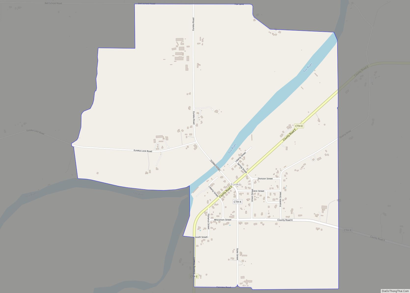
Map of Fennimore city
Fennimore is a city in Grant County, Wisconsin, United States. The population was 2,497 at the 2010 census. The city’s area was separated from the Town of Fennimore, which remains as an adjacent rural area. Fennimore city overview: Name: Fennimore city LSAD Code: 25 LSAD Description: city (suffix) State: Wisconsin County: Grant County Elevation: 1,194 ft ... Read more
Map of Fennimore city
Map of Fall River village, Wisconsin
Fall River is a village in Columbia County, Wisconsin, United States, along the North Fork of the Crawfish River. The population was 1,712 at the 2010 census. It is part of the Madison Metropolitan Statistical Area. Fall River village overview: Name: Fall River village LSAD Code: 47 LSAD Description: village (suffix) State: Wisconsin County: Columbia ... Read more
Map of Fall River village, Wisconsin
Map of Fall Creek village
Fall Creek is a village in Eau Claire County, Wisconsin, United States. The population was 1,315 at the 2010 census. The village is bordered by the Town of Lincoln. Fall Creek village overview: Name: Fall Creek village LSAD Code: 47 LSAD Description: village (suffix) State: Wisconsin County: Eau Claire County Elevation: 938 ft (286 m) Total Area: ... Read more
Map of Fall Creek village
Map of Germantown village, Wisconsin
Germantown is a village in Washington County, Wisconsin, United States. The population was 19,749 at the 2010 census. The village surrounds the Town of Germantown. In July 2007, Germantown was ranked the 30th most appealing place to live in the United States by Money Magazine. Germantown village overview: Name: Germantown village LSAD Code: 47 LSAD ... Read more
Map of Germantown village, Wisconsin
Map of Fox Crossing village
Fox Crossing is a village in Winnebago County, Wisconsin, United States. It was incorporated from the former Town of Menasha in 2016. The population as of the 2020 census was 18,974. Fox Crossing is located in the Fox Cities region and the Appleton-Oshkosh-Neenah, WI CSA, the third largest metropolitan area in Wisconsin. Fox Crossing village ... Read more
Map of Fox Crossing village
Map of Gays Mills village
Gays Mills is a village in Crawford County, Wisconsin, United States. The population was 491 at the 2010 census. Gays Mills village overview: Name: Gays Mills village LSAD Code: 47 LSAD Description: village (suffix) State: Wisconsin County: Crawford County Elevation: 702 ft (214 m) Total Area: 4.90 sq mi (12.69 km²) Land Area: 4.87 sq mi (12.62 km²) Water Area: 0.03 sq mi (0.07 km²) Total ... Read more
Map of Gays Mills village
Map of Friesland village
Friesland is a village in Columbia County, Wisconsin, United States. The population was 320 at the 2020 census. It is part of the Madison Metropolitan Statistical Area. Friesland village overview: Name: Friesland village LSAD Code: 47 LSAD Description: village (suffix) State: Wisconsin County: Columbia County Elevation: 1,007 ft (307 m) Total Area: 1.01 sq mi (2.62 km²) Land Area: 1.00 sq mi ... Read more
Map of Friesland village
Map of Friendship village, Wisconsin
Friendship is a village in Adams County in the U.S. state of Wisconsin. It is the county seat of Adams County. The population was 725 at the 2010 census. Friendship village overview: Name: Friendship village LSAD Code: 47 LSAD Description: village (suffix) State: Wisconsin County: Adams County Elevation: 955 ft (291 m) Total Area: 0.94 sq mi (2.45 km²) Land ... Read more
Map of Friendship village, Wisconsin
Map of French Island CDP
French Island is a census-designated place (CDP) in La Crosse County, Wisconsin, United States. The population was 4,207 at the 2010 census. It lies on an island of the same name, though they are not coextensive; a portion of the island is part of the city of La Crosse. All of the island is part ... Read more
Map of French Island CDP
Map of Frederic village
Frederic is a village in Polk County, Wisconsin, United States. The population was 1,137 at the 2010 census. Frederic village overview: Name: Frederic village LSAD Code: 47 LSAD Description: village (suffix) State: Wisconsin County: Polk County Elevation: 1,214 ft (370 m) Total Area: 1.76 sq mi (4.56 km²) Land Area: 1.69 sq mi (4.38 km²) Water Area: 0.07 sq mi (0.18 km²) Total Population: 1,137 Population ... Read more
Map of Frederic village
Map of Franks Field CDP
Franks Field is a census-designated place in the town of Sanborn, Ashland County, Wisconsin, United States. Its population was 154 as of the 2010 census. Franks Field is located on the Bad River Indian Reservation. Franks Field CDP overview: Name: Franks Field CDP LSAD Code: 57 LSAD Description: CDP (suffix) State: Wisconsin County: Ashland County ... Read more
Map of Franks Field CDP
Map of Gilman village, Wisconsin
Gilman is a village in Taylor County, Wisconsin, United States. The population was 410 at the 2010 census. The village is located between the towns of Aurora and Ford. Gilman village overview: Name: Gilman village LSAD Code: 47 LSAD Description: village (suffix) State: Wisconsin County: Taylor County Elevation: 1,224 ft (373 m) Total Area: 2.34 sq mi (6.06 km²) Land ... Read more
Map of Gilman village, Wisconsin