Evansville is a city in Rock County, Wisconsin, United States. The population was 5,703 at the 2020 census. Evansville is a part of the Janesville-Beloit Metropolitan Statistical Area and the Madison-Janesville-Beloit CSA.
| Name: | Evansville city |
|---|---|
| LSAD Code: | 25 |
| LSAD Description: | city (suffix) |
| State: | Wisconsin |
| County: | Rock County |
| Elevation: | 912 ft (278 m) |
| Total Area: | 3.31 sq mi (8.58 km²) |
| Land Area: | 3.25 sq mi (8.43 km²) |
| Water Area: | 0.06 sq mi (0.15 km²) |
| Total Population: | 5,703 |
| Population Density: | 1,752.1/sq mi (676.4/km²) |
| Area code: | 608 |
| FIPS code: | 5524550 |
| GNISfeature ID: | 1564732 |
| Website: | www.ci.evansville.wi.gov |
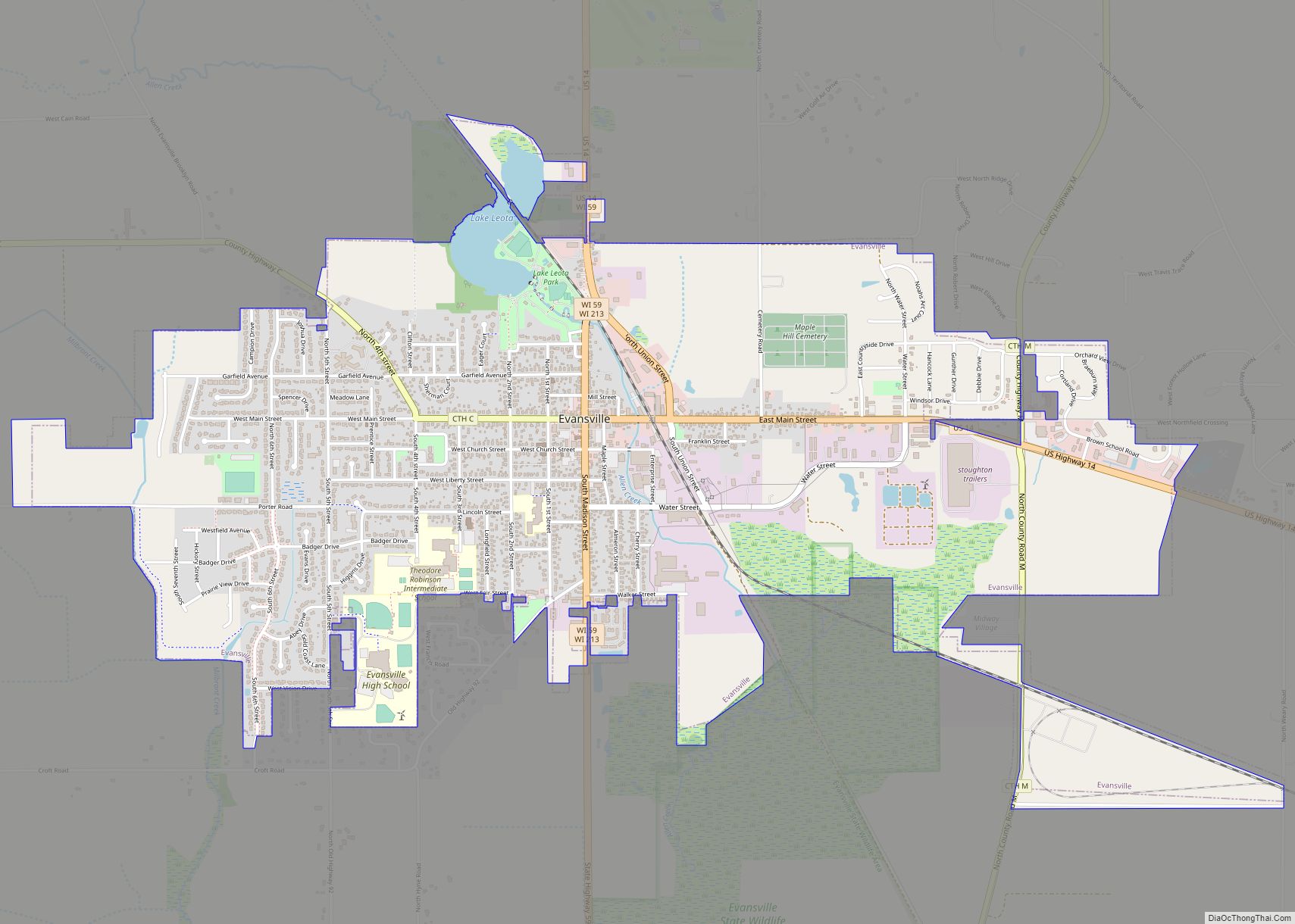
Online Interactive Map
Click on ![]() to view map in "full screen" mode.
to view map in "full screen" mode.
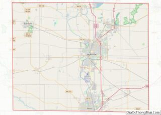
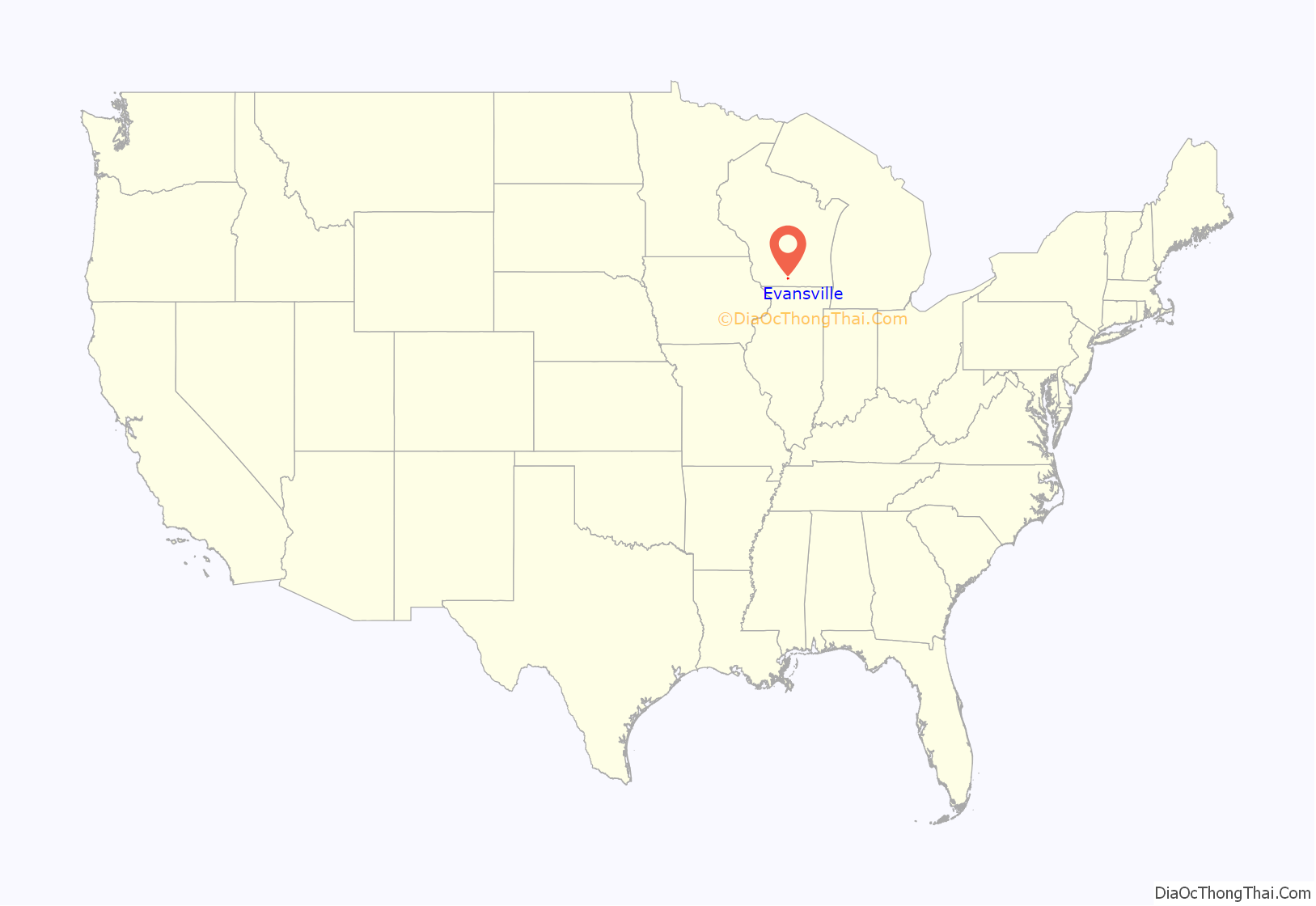
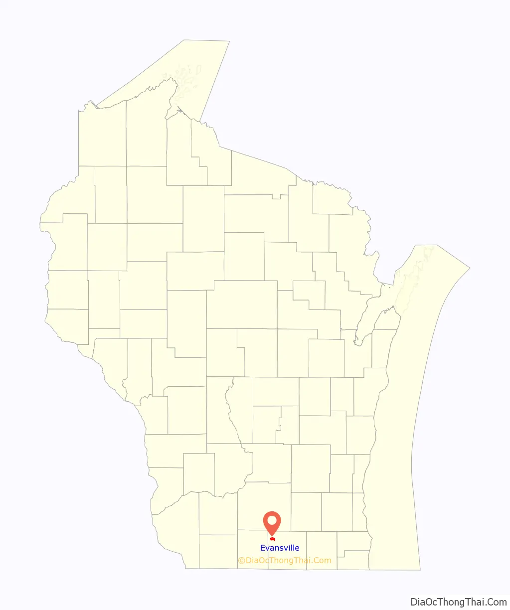
Evansville location map. Where is Evansville city?
History
Evansville was first settled in the 1830s by New Englanders who were attracted to the area by its pristine wooded landscape and the placid Allen Creek. By 1855, the city recorded its first plat and was complete with homes, shops, and churches. Evansville is named for Dr. John M. Evans, a doctor and postmaster during the city’s early years.
In 1863, the Chicago and North Western Railway came to Evansville, accelerating growth. At this point, Evansville’s economy was based on industry and manufacturing of carriages, wagons, pumps, windmills and iron castings. The economy was also based on agriculture: dairying; farming (production of wheat and tobacco); and stock raising.
By the turn of the twentieth century Evansville had over 1900 residents, and by the 1920s, most of the buildings in Evansville’s future Historic District were completed.
The first newspaper, Badger, was established in 1894 by native sisters, Eleanor and Marilla Andrews and was run by all female employees. The first paper, Vol. 1, no. 1 was published on Oct. 13, 1894 and the last, Vol. 12, no. 14 on Apr. 7, 1906.
1918 mob attacks
On November 11, 1918, Armistice Day activities celebrating the end of World War I took an ugly turn as some Evansville citizens began rounding up townspeople who they had deemed insufficiently supportive of the war, mainly due to their refusal or inability to buy war bonds. A German minister and his wife were apprehended on their way out of town before being brought downtown and forced to kiss the American flag. Other “slackers” were made to wear sleighbells as they rode atop a car’s radiator, while others were forced to dance in a snake formation around a bonfire. A 73-year-old woman who passed on participating in the “Your Share is Fair” war bond campaign was dragged from her home by the mob, placed in a large animal cage and paraded about the streets before being parked before the fire. The woman, Mary J. Shaw, had previously bought bonds and supported the Red Cross and other war relief efforts. After refusing to salute or kiss the flag she was rescued by other citizens. Her attempts to see her assailants punished were brushed aside by the local sheriff, and testimony before the state legislature was similarly disregarded.
Historic District
The Evansville Historic District, which surrounds Main Street and stretches to the side streets of Garfield Avenue and Liberty Street, includes dozens of historic homes and other structures. The Wisconsin Historical Society called Evansville home to “the finest collection of 1840s to 1915 architecture of any small town in Wisconsin.”
The Eager Free Public Library building was built with the bequest of a leading citizen, Almeron Eager, in 1908. Designed by the architectural firm of Claude and Starck of Madison, Wisconsin in the Prairie style, it features stained glass windows and plaster friezes just below the overhanging roof line. A 1994 addition at the rear of the original building was designed to match the original architecture, while adding much needed space and handicapped accessibility. The intersection on which the library stands also contains a Greek Revival home (now a funeral parlor), a High Victorian Gothic brick home (now housing the local Masonic Temple) and a classic Victorian “Painted Lady” home, still a private residence.
The Evansville Seminary was located near College Drive in the district. Its building was designed by architect August Kutzbock, but now functions as apartment homes.
In 1978, the historic district was placed on the National Register of Historic Places.
Evansville Road Map
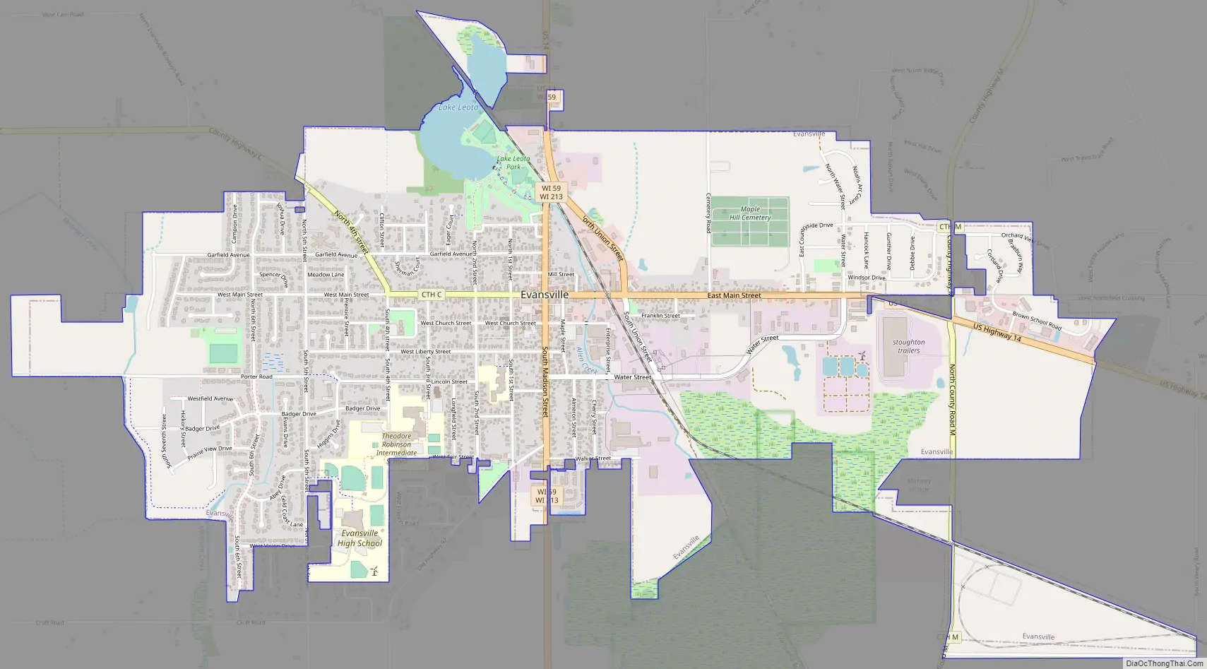
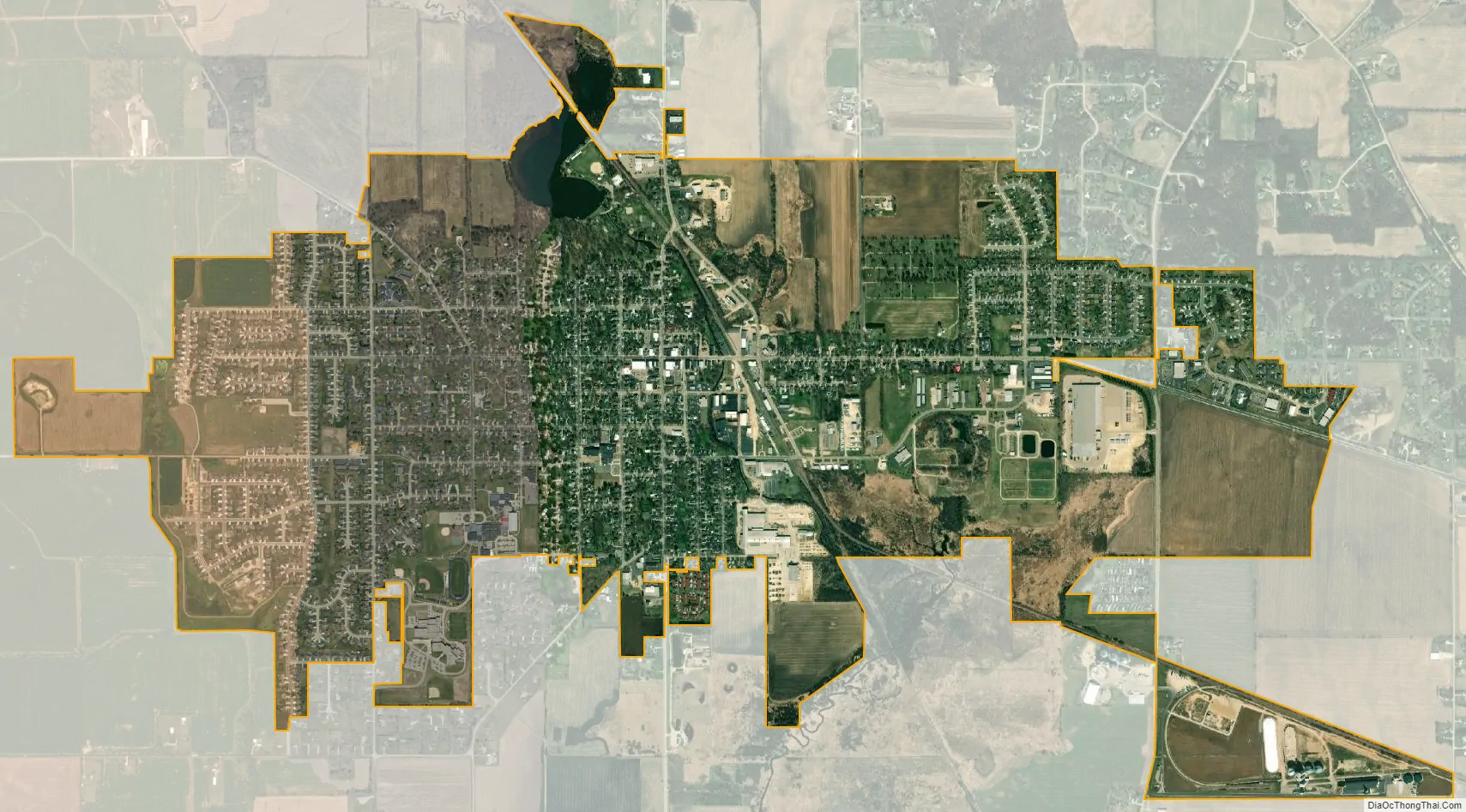
Evansville city Satellite Map
Geography
Evansville is located at 42°46′48″N 89°18′01″W / 42.779917°N 89.300378°W / 42.779917; -89.300378 (42.779917, -89.300378).
According to the United States Census Bureau, the city has a total area of 3.31 square miles (8.57 km), of which, 3.25 square miles (8.42 km) is land and 0.06 square miles (0.16 km) is water.
Evansville is located 23 miles (37 km) south of Madison, Wisconsin, 20 miles (32 km) northwest of Janesville, Wisconsin, and 40 miles (64 km) northwest of Beloit, Wisconsin.
Lake Leota
This 18-acre (73,000 m) lake was formed by damming Allen Creek in the 1840s as a mill pond. Because of erosion into Allen Creek from upstream farm fields and the resulting silt deposits that accumulated, Lake Leota had become shallower over the years, reaching an average depth of only one and a half feet by 2000. One major issue that faced the city in the last 30 years was how to restore the lake to its original depth. The dam was opened in September 2005 to allow the lake to drain and its bottom to dry out. There was some controversy in Evansville over the cost of dredging, so a referendum was put to the city’s voters in November 2008. It passed by almost two to one, and dredging to a maximum of ten-foot depth was completed in February 2009. The dam was closed shortly thereafter, and Lake Leota was refilled slowly. A ceremony to mark the renaissance of the lake was held on July 4, 2009. Citizens can now enjoy the natural beauty of the lake, boating in non-powered craft, and fishing. Since refilling, the lake has been stocked with panfish and bass, and “fish-cribs” sunk below the lake surface to provide breeding areas and cover for small fry.
See also
Map of Wisconsin State and its subdivision:- Adams
- Ashland
- Barron
- Bayfield
- Brown
- Buffalo
- Burnett
- Calumet
- Chippewa
- Clark
- Columbia
- Crawford
- Dane
- Dodge
- Door
- Douglas
- Dunn
- Eau Claire
- Florence
- Fond du Lac
- Forest
- Grant
- Green
- Green Lake
- Iowa
- Iron
- Jackson
- Jefferson
- Juneau
- Kenosha
- Kewaunee
- La Crosse
- Lafayette
- Lake Michigan
- Lake Superior
- Langlade
- Lincoln
- Manitowoc
- Marathon
- Marinette
- Marquette
- Menominee
- Milwaukee
- Monroe
- Oconto
- Oneida
- Outagamie
- Ozaukee
- Pepin
- Pierce
- Polk
- Portage
- Price
- Racine
- Richland
- Rock
- Rusk
- Saint Croix
- Sauk
- Sawyer
- Shawano
- Sheboygan
- Taylor
- Trempealeau
- Vernon
- Vilas
- Walworth
- Washburn
- Washington
- Waukesha
- Waupaca
- Waushara
- Winnebago
- Wood
- Alabama
- Alaska
- Arizona
- Arkansas
- California
- Colorado
- Connecticut
- Delaware
- District of Columbia
- Florida
- Georgia
- Hawaii
- Idaho
- Illinois
- Indiana
- Iowa
- Kansas
- Kentucky
- Louisiana
- Maine
- Maryland
- Massachusetts
- Michigan
- Minnesota
- Mississippi
- Missouri
- Montana
- Nebraska
- Nevada
- New Hampshire
- New Jersey
- New Mexico
- New York
- North Carolina
- North Dakota
- Ohio
- Oklahoma
- Oregon
- Pennsylvania
- Rhode Island
- South Carolina
- South Dakota
- Tennessee
- Texas
- Utah
- Vermont
- Virginia
- Washington
- West Virginia
- Wisconsin
- Wyoming