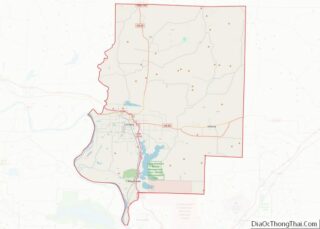
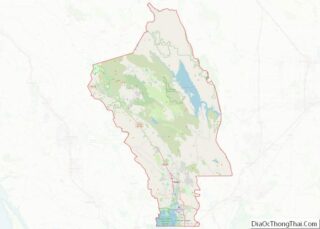
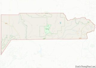
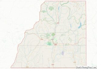
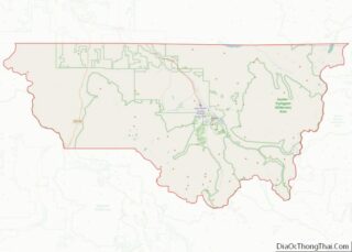
Map of Roosevelt County

Map of Roosevelt County, Montana

Roosevelt County is a county in the U.S. state of Montana. As of the 2020 census, the population was 10,794. Its county seat is Wolf Point. Roosevelt County was created by the Montana Legislature in 1919 from a portion of Sheridan County. The name honors former president Theodore Roosevelt, who had died earlier that year. … Read more

Map of Arthur County

Map of Arthur County, Nebraska

Arthur County is a county located in the U.S. state of Nebraska. As of the 2020 United States Census, the population was 434, making it Nebraska’s third least populous county and the seventh-least populous county in the United States (behind only Loving County, Texas; Kalawao County, Hawaii; King County, Texas; Kenedy County, Texas; McPherson County, … Read more

Map of Colfax County

Map of Colfax County, Nebraska

Colfax County overview: Name: Colfax County FIPS code: 31-037 State: Nebraska Founded: 1869 Named for: Schuyler Colfax Seat: Schuyler Largest city: Schuyler Total Area: 417 sq mi (1,080 km²) Land Area: 412 sq mi (1,070 km²) Total Population: 10,498 Population Density: 25.7/sq mi (9.9/km²) Time zone: UTC−6 (Central) Summer Time Zone (DST): UTC−5 (CDT) Website: www.colfaxne.com Colfax County location map. Where is … Read more

Map of Garden County

Map of Garden County, Nebraska

Garden County is a county in the U.S. state of Nebraska. As of the 2010 United States Census, the population was 2,057. Its county seat is Oshkosh. In the Nebraska license plate system, Garden County is represented by the prefix 77 (it had the seventy-seventh-largest number of vehicles registered in the state when the license … Read more

Map of Keith County

Map of Keith County, Nebraska

Keith County is a county in the U.S. state of Nebraska. As of the 2010 United States Census, the population was 8,368. Its county seat is Ogallala. In the Nebraska license plate system, Keith County is represented by the prefix 68 (it had the sixty-eighth-largest number of vehicles registered in the county when the license … Read more

Map of Pawnee County

Map of Pawnee County, Nebraska

Pawnee County is a county in the U.S. state of Nebraska. As of the 2010 United States Census, the population was 2,773. Its county seat is Pawnee City. In the Nebraska license plate system, Pawnee County is represented by the prefix 54 (it had the fifty-fourth-largest number of vehicles registered in the county when the … Read more

Map of Sioux County

Map of Sioux County, Nebraska

Sioux County is a county in the U.S. state of Nebraska. As of the 2010 United States Census, the population was 1,311. Its county seat is Harrison. Sioux County is included in the Scottsbluff, NE Micropolitan Statistical Area. In the Nebraska license plate system, Sioux County is represented by the prefix 80 (it had the … Read more

Map of Esmeralda County

Map of Esmeralda County, Nevada

Esmeralda County overview: Name: Esmeralda County FIPS code: 32-009 State: Nevada Founded: November 25, 1861 Named for: Emerald Seat: Goldfield Total Area: 3,589 sq mi (9,300 km²) Land Area: 3,582 sq mi (9,280 km²) Total Population: 729 Population Density: 0.20/sq mi (0.078/km²) Time zone: UTC−8 (Pacific) Summer Time Zone (DST): UTC−7 (PDT) Website: www.accessesmeralda.com Esmeralda County location map. Where is Esmeralda County? … Read more

Map of Grafton County

Map of Grafton County, New Hampshire

Grafton County is a county in the U.S. state of New Hampshire. As of the 2020 census, the population was 91,118. Its county seat is North Haverhill, a village within the town of Haverhill. Until 1972, the county courthouse and other offices were in downtown Woodsville, a larger village within the town of Haverhill. Grafton … Read more

Map of Mercer County

Map of Mercer County, New Jersey

Mercer County is a county located in the U.S. state of New Jersey. Its county seat is Trenton, also the state capital, prompting its nickname The Capital County. Mercer County alone constitutes the Trenton–Princeton metropolitan statistical area and is considered part of the New York metropolitan area by the U.S. Census Bureau, but also directly … Read more

Map of Curry County

Map of Curry County, New Mexico

Curry County is a county located in the U.S. state of New Mexico. As of the 2010 census, its population was 48,376. Its county seat is Clovis. The county is named in honor of George Curry, territorial governor of New Mexico from 1907 to 1910. Curry County comprises the Clovis, New Mexico micropolitan statistical area, … Read more

Map of Rio Arriba County

Map of Rio Arriba County, New Mexico

Rio Arriba County (Spanish: Condado de Río Arriba) is a county in the U.S. state of New Mexico. As of the 2010 census, the population was 40,246. Its county seat is Tierra Amarilla. Its northern border is the Colorado state line. Rio Arriba County comprises the Española, NM Micropolitan Statistical Area, which is also included … Read more