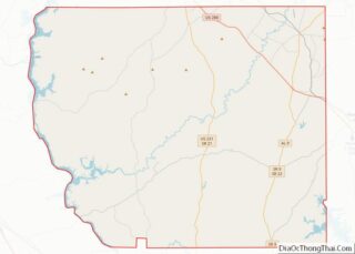
Map of Johnston County

Map of Johnston County, North Carolina

Johnston County is a county located in the U.S. state of North Carolina. As of the 2020 census, the population was 215,999. Its county seat is Smithfield. Johnston County is included in the Raleigh, NC Metropolitan Statistical Area, which is also included in the Raleigh–Durham–Chapel Hill, NC Combined Statistical Area, which has a population of … Read more

Map of Onslow County

Map of Onslow County, North Carolina

Onslow County is a county located in the U.S. state of North Carolina. As of the 2020 census, the population was 204,576. Its county seat is Jacksonville. The county was created in 1734 as Onslow Precinct and gained county status in 1739. Onslow County comprises the Jacksonville, NC Metropolitan Statistical Area. The southern border is … Read more

Map of Scotland County

Map of Scotland County, North Carolina

Scotland County is a county located in the southern part of the U.S. state of North Carolina and is its smallest county by area. Its county seat is and largest city is Laurinburg. The county was formed in 1899 from part of Richmond County and named in honor of the Scottish settlers who occupied the … Read more

Map of Yadkin County

Map of Yadkin County, North Carolina

Yadkin County is located in the U.S. state of North Carolina. As of the 2020 census, the population was 37,214. Its county seat is Yadkinville. Yadkin County is included in the Winston-Salem, NC Metropolitan Statistical Area, which is also included in the Greensboro-Winston-Salem-High Point, NC Combined Statistical Area. Yadkin County overview: Name: Yadkin County FIPS … Read more

Map of Foster County

Map of Foster County, North Dakota

Foster County is a county in the U.S. state of North Dakota. As of the 2020 census, the population was 3,397. Its county seat is Carrington. Foster County overview: Name: Foster County FIPS code: 38-031 State: North Dakota Founded: 1873 Seat: Carrington Largest city: Carrington Total Area: 647 sq mi (1,680 km²) Land Area: 635 sq mi (1,640 km²) Total Population: … Read more

Map of Nelson County

Map of Nelson County, North Dakota

Nelson County is a county in the U.S. state of North Dakota. As of the 2020 census, the population was 3,015. Its county seat is Lakota. Nelson County overview: Name: Nelson County FIPS code: 38-063 State: North Dakota Founded: 1883 Seat: Lakota Largest city: Lakota Total Area: 1,009 sq mi (2,610 km²) Land Area: 982 sq mi (2,540 km²) Total Population: … Read more

Map of Towner County

Map of Towner County, North Dakota

Towner County is a county in the U.S. state of North Dakota. As of the 2020 census, the population is 2,162. Its county seat is Cando. It is south of the Canada–US border with Manitoba. Towner County overview: Name: Towner County FIPS code: 38-095 State: North Dakota Founded: 1883 Named for: Oscar M. Towner Seat: … Read more

Map of Champaign County

Map of Champaign County, Ohio

Champaign County is a county located in the U.S. state of Ohio. As of the 2020 census, the population was 38,714. Its county seat and largest city is Urbana. The county takes its name from the French word for “open level country”. Champaign County became the 18th of 88 Ohio counties on March 1, 1805. … Read more

Map of Gallia County

Map of Gallia County, Ohio

Gallia County (pronunciation: GAL-yuh) is a county located in the U.S. state of Ohio. As of the 2020 census, the population was 29,220. Its county seat and largest village is Gallipolis. Named after the French people who originally settled there, its name “Gallia” is the Latin word for Gaul, the ancient region of Western Europe … Read more

Map of Lake County

Map of Lake County, Ohio

Lake County is a county in the U.S. state of Ohio. As of the 2020 census, the population was 232,603. The county seat is Painesville. The county was established on March 6, 1840, from land given by Cuyahoga and Geauga Counties. Its name is derived from its location on the southern shore of Lake Erie. … Read more

Map of Morgan County

Map of Morgan County, Ohio

Morgan County is a county located in the U.S. state of Ohio. As of the 2020 census, the population was 13,802, making it the third-least populous county in Ohio. Its county seat is McConnelsville. The county was created in 1817 and later organized in 1819. It is named for Daniel Morgan, an officer in the … Read more

Map of Seneca County

Map of Seneca County, Ohio

Seneca County is a county located in the northwestern part of the U.S. state of Ohio. As of the 2020 census, the population was 55,069. Its county seat is Tiffin. The county was created in 1820 and organized in 1824. It is named for the Seneca Indians, the westernmost nation of the Iroquois Confederacy. This … Read more