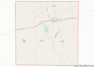
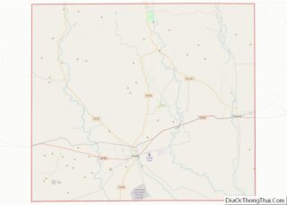
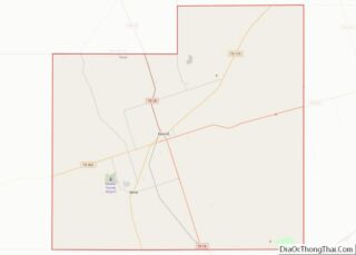
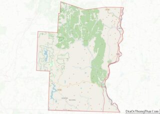
Map of Menard County

Map of Menard County, Texas

Menard County overview: Name: Menard County FIPS code: 48-327 State: Texas Founded: 1871 Named for: Michel Branamour Menard Seat: Menard Largest city: Menard Total Area: 902 sq mi (2,340 km²) Land Area: 902 sq mi (2,340 km²) Total Population: 1,962 Population Density: 2.2/sq mi (0.84/km²) Time zone: UTC−6 (Central) Summer Time Zone (DST): UTC−5 (CDT) Website: co.menard.tx.us Menard County location map. Where … Read more

Map of Oldham County

Map of Oldham County, Texas

Oldham County is a county located in the U.S. state of Texas. As of the 2020 census, its population was 1,758. Its county seat is Vega. The county was created in 1876 and organized in 1881. Oldham County is included in the Amarillo, TX Metropolitan Statistical Area. Oldham County overview: Name: Oldham County FIPS code: … Read more

Map of Refugio County

Map of Refugio County, Texas

Refugio County (/rɪˈfjʊəriː.oʊ/ rih-FYOOR-ee-oh) is a county located in the U.S. state of Texas. As of the 2020 census, its population was 6,741. Its county seat is Refugio. The county originated as a municipality of Mexico in 1834 and was classified as a county in 1837. Refugio County overview: Name: Refugio County FIPS code: 48-391 … Read more

Map of Smith County

Map of Smith County, Texas

Smith County is a county in the U.S. state of Texas. As of the 2020 census, its population was 233,479. Its county seat is Tyler. Smith County is named for James Smith, a general during the Texas Revolution. Smith County is part of the Tyler metropolitan statistical area and the Tyler–Jacksonville combined statistical area. Smith … Read more

Map of Trinity County

Map of Trinity County, Texas

Trinity County is a county located in the U.S. state of Texas. As of the 2020 census, the population was 13,602. Its county seat is Groveton. The county is named for the Trinity River. Trinity County is included in the Huntsville, TX Micropolitan Statistical Area, which is also included in the Houston-The Woodlands, TX Combined … Read more

Map of Wilbarger County

Map of Wilbarger County, Texas

Wilbarger County overview: Name: Wilbarger County FIPS code: 48-487 State: Texas Founded: 1881 Named for: Josiah Pugh Wilbarger and Mathias Wilbarger Seat: Vernon Largest city: Vernon Total Area: 978 sq mi (2,530 km²) Land Area: 971 sq mi (2,510 km²) Total Population: 12,887 Population Density: 13/sq mi (5.1/km²) Time zone: UTC−6 (Central) Summer Time Zone (DST): UTC−5 (CDT) Website: www.co.wilbarger.tx.us Wilbarger County … Read more

Map of Davis County

Map of Davis County, Utah

Davis County is a county in northern Utah, United States. As of the 2010 United States Census, the population was 306,479, making it Utah’s third-most populous county. Its county seat is Farmington, and its largest city is Layton. Davis County is part of the Ogden–Clearfield, UT Metropolitan Statistical Area as well as the Salt Lake … Read more

Map of Summit County

Map of Summit County, Utah

Summit County is a county in the U.S. state of Utah, occupying a rugged and mountainous area. As of the 2010 United States Census, the population was 36,324. Its county seat is Coalville, and the largest city is Park City. Summit County overview: Name: Summit County FIPS code: 49-043 State: Utah Founded: 1854 Named for: … Read more

Map of Orange County

Map of Orange County, Vermont

Orange County is a county located in the U.S. state of Vermont. As of the 2020 census, the population was 29,277. Its shire town (county seat) is the town of Chelsea. Orange County was organized on February 2, 1781, as an original county within the state. Orange County overview: Name: Orange County FIPS code: 50-017 … Read more

Map of Bedford County

Map of Bedford County, Virginia

Bedford County is a United States county located in the Piedmont region of the Commonwealth of Virginia. Its county seat is the town of Bedford, which was an independent city from 1968 until rejoining the county in 2013. Bedford County was created in 1753 from parts of Lunenburg County, and several changes in alignment were … Read more

Map of Chesterfield County

Map of Chesterfield County, Virginia

Chesterfield County is located just south of Richmond in the Commonwealth of Virginia. The county’s borders are primarily defined by the James River to the north and the Appomattox River to the south. Its county seat is Chesterfield Court House. Chesterfield County was formed in 1749 from parts of Henrico County. It was named for … Read more

Map of Fauquier County

Map of Fauquier County, Virginia

Fauquier /fɔːˈkɪər/ is a county in the Commonwealth of Virginia. As of the 2020 census, the population was 72,972. The county seat is Warrenton. Fauquier County is in Northern Virginia and is a part of the Washington metropolitan area. Fauquier County overview: Name: Fauquier County FIPS code: 51-061 State: Virginia Founded: 1759 Named for: Francis … Read more