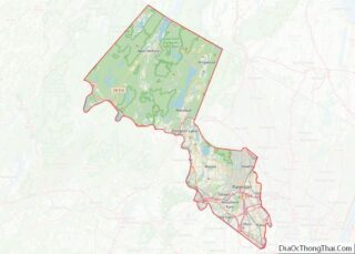
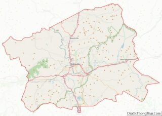
Map of Mountrail County, North Dakota
Mountrail County is a county in the northwestern part of North Dakota, United States. As of the 2020 census, the population was 9,809. Its county seat is Stanley. The county was originally created in 1873, then removed in 1892, annexed by Ward County. It was re-created and organized in 1909. Mountrail County overview: Name: Mountrail ... Read more
Map of Mountrail County, North Dakota
Map of Stutsman County, North Dakota
Stutsman County is a county in the U.S. state of North Dakota. As of the 2020 census, the population was 21,593. Its county seat is Jamestown. The Jamestown, North Dakota Micropolitan Statistical Area includes all of Stutsman County. Stutsman County overview: Name: Stutsman County FIPS code: 38-093 State: North Dakota Founded: 1873 Named for: Enos ... Read more
Map of Stutsman County, North Dakota
Map of Carroll County, Ohio
Carroll County is a county located in the state of Ohio. As of the 2020 census, the population was 26,721. Its county seat is Carrollton, while its largest village is Minerva. It is named for Charles Carroll of Carrollton, the last surviving signer of the Declaration of Independence. Carroll County is part of the Canton-Massillon, ... Read more
Map of Carroll County, Ohio
Map of Fulton County, Ohio
Fulton County overview: Name: Fulton County FIPS code: 39-051 State: Ohio Founded: April 1, 1850 Named for: Robert Fulton Seat: Wauseon Largest city: Wauseon Total Area: 407 sq mi (1,050 km²) Land Area: 405 sq mi (1,050 km²) Total Population: 42,713 Population Density: 100/sq mi (40/km²) Time zone: UTC−5 (Eastern) Summer Time Zone (DST): UTC−4 (EDT) Website: www.fultoncountyoh.com Fulton County location map. ... Read more
Map of Fulton County, Ohio
Map of Knox County, Ohio
Knox County is a county located in the U.S. state of Ohio. As of the 2020 census, the population was 62,721. Its county seat is Mount Vernon. The county is named for Henry Knox, an officer in the American Revolutionary War who was later the first Secretary of War. Knox County comprises the Mount Vernon, ... Read more
Map of Knox County, Ohio
Map of Montgomery County, Ohio
Montgomery County is located in the southwestern portion of the U.S. state of Ohio. As of the 2020 census, the population was 537,309, making it the fifth-most populous county in Ohio. The county seat is Dayton. The county was named in honor of Richard Montgomery, an American Revolutionary War general killed in 1775 while attempting ... Read more
Map of Montgomery County, Ohio
Map of Scioto County, Ohio
Scioto County is a county located along the Ohio River in the south central region of the U.S. state of Ohio. As of the 2020 census, the population was 74,008. Its county seat is Portsmouth. The county was founded March 24, 1804, from Adams County and is named for a Native American word referring to ... Read more
Map of Scioto County, Ohio
Map of Adair County, Oklahoma
Adair County is a county located in the U.S. state of Oklahoma. As of the 2010 census, the population was 22,286. Its county seat is Stilwell. Adair County was named after the Adair family of the Cherokee tribe. One source says that the county was specifically named for Watt Adair, one of the first Cherokees ... Read more
Map of Adair County, Oklahoma
Map of Cotton County, Oklahoma
Cotton County is a county located in the U.S. state of Oklahoma. As of the 2010 census, the population was 6,193. Its county seat is Walters. When Oklahoma achieved statehood in 1907, the area which is now Cotton County fell within the boundaries of Comanche County. It was split off in 1912, becoming the last ... Read more
Map of Cotton County, Oklahoma
Map of Jackson County, Oklahoma
Jackson County is a county located in the southwestern corner of the U.S. state of Oklahoma. As of the 2010 census, the population was 26,446. Its county seat is Altus. According to the Encyclopedia of Oklahoma History and Culture, the county was named for two historical figures: President Andrew Jackson and Confederate General Stonewall Jackson. ... Read more
Map of Jackson County, Oklahoma
Map of McIntosh County, Oklahoma
McIntosh County is a county located in the U.S. state of Oklahoma. As of the 2010 census, the population was 20,252. Its county seat is Eufaula. The county is named for an influential Muscogee Creek family, whose members led the migration of the Lower Towns to Indian Territory and served as leaders for generations. It ... Read more
Map of McIntosh County, Oklahoma
Map of Roger Mills County, Oklahoma
Roger Mills County is a county located in the western part of the U.S. state of Oklahoma. As of the 2010 census, the population was 3,647, making it the third-least populous county in Oklahoma. Its county seat is Cheyenne. The county was created in 1891. Roger Mills county is located above the petroleum-rich Panhandle-Hugoton Field, ... Read more
Map of Roger Mills County, Oklahoma