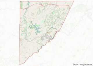
Carlisle County is a county located in the U.S. state of Kentucky. As of the 2020 census, the population was 4,826, making it the fourth-least populous county in Kentucky. Its county seat is Bardwell. The county was founded in 1886 and named for John Griffin Carlisle, a Speaker of the United States House of Representatives ... Read more
Map of US Counties
Floyd County is a county located in the U.S. state of Kentucky. As of the 2020 census, the population was 35,942. Its county seat is Prestonsburg. The county, founded in 1800, is named for Colonel John Floyd (1750–1783). Floyd County overview: Name: Floyd County FIPS code: 21-071 State: Kentucky Founded: 1800 Named for: John Floyd ... Read more
Henry County is a county located in the north central portion of the U.S. state of Kentucky bordering the Kentucky River. As of the 2020 census, the population was 15,678. Its county seat is New Castle, but its largest city is Eminence. The county was founded in 1798 from portions of Shelby County. It was ... Read more
Lewis County is a county located in the U.S. state of Kentucky. Its county seat is Vanceburg. Lewis County overview: Name: Lewis County FIPS code: 21-135 State: Kentucky Founded: December 2, 1806 Named for: Meriwether Lewis Seat: Vanceburg Largest city: Vanceburg Total Area: 495 sq mi (1,280 km²) Land Area: 483 sq mi (1,250 km²) Total Population: 13,080 Population Density: 26/sq mi ... Read more
Mercer County is a county located in the central part of the U.S. Commonwealth of Kentucky. As of the 2020 census, the population was 23,772. Its county seat is Harrodsburg. The county was formed from Lincoln County, Virginia in 1785 and is named for Revolutionary War General Hugh Mercer, who was killed at the Battle ... Read more
Pulaski County is a county in the U.S. Commonwealth of Kentucky. As of the 2020 census, the population was 65,034. Its county seat is Somerset. The county was founded in December 1798 from land given by Lincoln and Green Counties and named for Polish patriot Count Casimir Pulaski. Pulaski County comprises the Somerset, KY Micropolitan ... Read more
Wayne County is a county in the U.S. state of Kentucky along the southern border with Tennessee. As of the 2020 census, the population was 19,555. Its county seat is Monticello. The county, on the south-central border with Tennessee, was named for Gen. Anthony Wayne, a Revolutionary War hero. As of November 3, 2020, Wayne ... Read more
Cameron Parish (French: Paroisse de Cameron) is a parish in the southwest corner of the U.S. state of Louisiana. As of the 2020 census, the population was 5,617. The parish seat is Cameron. Although it is the largest parish by area in Louisiana, it has the second-smallest population in the state, ahead of only Tensas. ... Read more
LaSalle Parish overview: Name: LaSalle Parish FIPS code: 22-059 State: Louisiana Founded: January 1, 1910 Named for: René-Robert Cavelier, Sieur de La Salle Seat: Jena Total Area: 1,710 km² (662 sq mi) Land Area: 1,620 km² (625 sq mi) Total Population: 14,791 Population Density: 8.6/km² (22/sq mi) Time zone: UTC-6 (CST) Summer Time Zone (DST): UTC-5 (CDT) LaSalle Parish location map. Where ... Read more
St. Bernard Parish (French: Paroisse de Saint-Bernard; Spanish: Parroquia de San Bernardo) is a parish in the U.S. state of Louisiana. The parish seat and largest community is Chalmette. The parish was formed in 1807. St. Bernard Parish is part of the New Orleans–Metairie metropolitan statistical area; the parish is located southeast of the city ... Read more
West Baton Rouge Parish (French: Paroisse de Bâton Rouge Ouest) is one of the sixty-four parishes in the U.S. state of Louisiana. Established in 1807, its parish seat is Port Allen. With a 2020 census population of 27,199 residents, West Baton Rouge Parish is part of the Baton Rouge metropolitan statistical area. The parish has ... Read more
Somerset County is a county in the state of Maine, in the United States. As of the 2020 census, the population was 50,477. Its county seat is Skowhegan. Somerset County overview: Name: Somerset County FIPS code: 23-025 State: Maine Founded: 1809 Named for: Somerset County, England Seat: Skowhegan Largest town: Skowhegan Total Area: 4,094 sq mi (10,600 km²) ... Read more